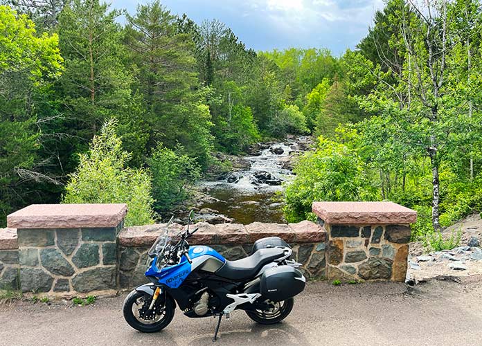
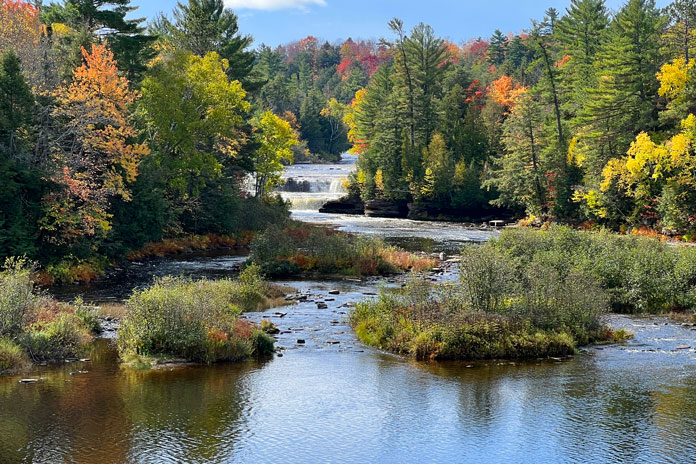
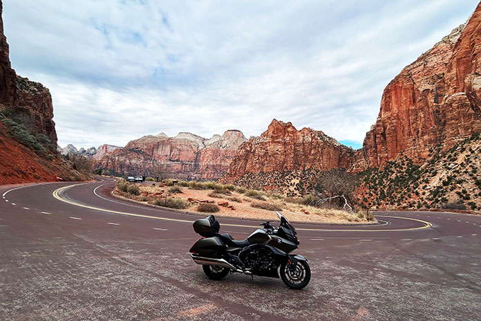
Originally built more than a century ago, Seven Bridges Road parallels and crosses Amity Creek, which cascades down a series of waterfalls for 400 vertical feet. This road was a highlight of this Minnesota motorcycle ride.
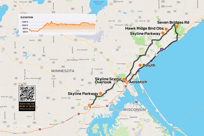
A couple summers ago, I flew to Minneapolis for a CFMOTO press launch and to visit our parent company’s home office. When CFMOTO gave me the key to a 650 ADVentura and let me loose for a day, I made a beeline north to Duluth to pay a visit to my friend Andy Goldfine and tour the Aerostich factory and store.
It was a hot, muggy morning when I left the hotel in a northern suburb of Minneapolis and made my way to Interstate 35. The 160-mile ride to Duluth took a little over two hours, and along the way, being in the Land of 10,000 Lakes, I passed countless billboards for fishing boats, fishing lakes, fish camps, and marinas. I also caught the edges of two rainstorms, which cooled me off in my mesh jacket and riding jeans. But as I-35 descended a steep hill toward downtown Duluth, the temperature dropped into the mid‑50s due to the cooling effect of Lake Superior. By the time I pulled into Aerostich’s parking lot, my teeth were chattering.
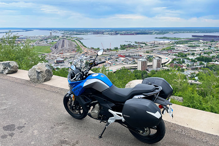
Skyline Parkway provides unparalleled views of downtown Duluth and Lake Superior.
Andy Goldfine has visited the Rider offices several times over the years, but I’d never been to the Aerostich factory before, so to get a personal tour by none other than Mr. Subjective himself was a real honor. After seeing the factory, Andy gave me the nickel tour of Duluth, and we had lunch at a cozy Italian eatery called Va Bene, where I warmed up with meatball soup and coffee.
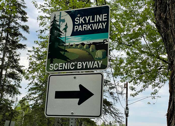
Before we parted, Andy took pity on me for being cold and gave me an Aerostich waterproof/windproof innershell to wear under my mesh jacket. He also suggested I check out Skyline Parkway, a scenic byway that runs several hundred feet above downtown Duluth and provides excellent views of the city and Lake Superior.
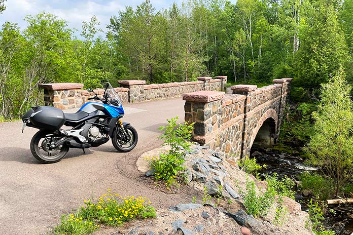
The series of stone arch bridges along Seven Bridges Road are a delight to behold.
I rode north along the lakeshore to Lester Park, where the Parkway begins on Occidental Boulevard as it goes due north along Amity Creek, ascending 400 feet as it follows and crosses a long cascade of waterfalls. In less than half a mile, the road crosses the creek, and its name becomes Seven Bridges Road. (The Steve Young song “Seven Bridges Road,” which was later covered by the Eagles and Dolly Parton, is about a street in Montgomery, Alabama.) Incidentally, the first bridge on Seven Bridges Road isn’t one of the eponymous seven; it’s designated “Bridge 0.”
Originally built more than a century ago, Seven Bridges Road parallels and crosses Amity Creek, which cascades down a series of waterfalls for 400 vertical feet.
Construction of Skyline Parkway began in 1889 along a plateau that was once the gravel shoreline of an ancient glacial lake that predates Lake Superior. Ten years later, a local land developer named Samuel F. Snively began construction of Seven Bridges Road. The original bridges were built in the early 1900s, but nearly all have been rebuilt in the past few decades, and each of the stone arch bridges is a work of civil engineering art.
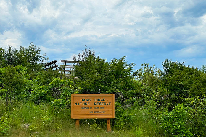
The northern part of Skyline Parkway is a gravel road that passes through the Hawk Ridge Nature Reserve. The wooden platform behind the sign is a bird observatory.
At the end of Seven Bridges Road, the Parkway takes a sharp left and turns to gravel as it enters the Hawk Ridge Nature Reserve. Several hiking trails branch off from the road, and the Hawk Ridge Bird Observatory is a popular place to watch raptor migrations.
The Parkway turns to pavement again as it meanders through a residential area. Riders must stay vigilant for the Parkway signs since several turns are required to stay on course. After crossing Chester Creek, the Parkway continues to wind through neighborhoods. Soon the houses on the lakeside of the road disappear, and riders are treated to expansive views of Lake Superior, downtown Duluth, and just across Saint Louis Bay, the neighboring city of Superior, Wisconsin.
The Hawk Ridge Nature Reserve is a wooded area crisscrossed with trails.
After passing Twin Ponds, Skyline Parkway runs along the edge of a golf course, goes over U.S. Route 53, and crosses several creeks before passing through wooded parkland. The scenery and views are pleasant the entire way. I jumped off the Parkway when it crossed I-35 to get back to Minneapolis, but it continues on the south side of the freeway, winding through the Magney‑Snively Natural Area before ending at Becks Road.
Overlooking downtown Duluth, the harbor, and – in the distance – Superior, Wisconsin.
If you plan to visit the Aerostich factory or will pass through Duluth during a Lake Superior Circle Tour or other Minnesota motorcycle ride, I highly recommend adding Skyline Parkway to your itinerary. Due to the icy winters in Duluth, parts of the Skyline Parkway are closed seasonally, so plan accordingly.
This Southern Minnesota motorcycle ride included an early morning stop at Church Hill Overlook on the Root River with a great view of the Lanesboro Stone Dam, constructed in 1868 with unmortared limestone blocks. (Photos by the author and Chad Cochran.)
Motorcyclists living in Minnesota experience long winters with plenty of time to think about roads we want to ride. It’s a sweet feeling when spring arrives and the bikes come out of hibernation.
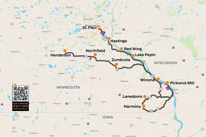
My son, Chad, feels the same way. We kicked off the riding season with an overnight Minnesota motorcycle ride down the Great River Road (U.S. Route 61) on the western bank of the Mississippi River, through what is often referred to as Bluff Country. The area’s complex hilly terrain has been carved out over eons by the Mississippi and other waterways large and small.
Minnesota’s Great River Road is a popular motorcycle route that offers epic beauty and a chance to visit towns along one of America’s most vital corridors of commerce. Starting in April with the annual “Flood Run” charity ride, thousands of riders thunder up and down these roads and frequent the many small-town bars and restaurants along the way. I’ve been on many of these roads before, and I love riding old favorites and exploring new side routes.
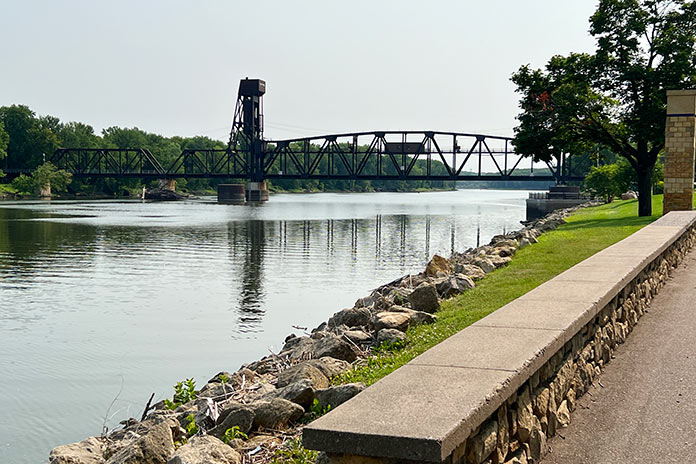
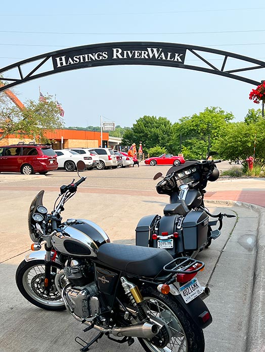
We left the Twin Cities early on a Saturday morning to beat traffic, and our first stop on this Minnesota motorcycle ride was the town of Hastings, which serves as a gateway to Bluff Country. The Hastings Riverwalk is a relatively new paved trail that connects to a 10-mile walking and biking loop along the Mississippi and Vermillion rivers. You can’t miss the towering Hastings Bridge, various sculptures along the waterfront, and the original footings of the Spiral Bridge, which was built in 1895 and dismantled in 1951.
The Hastings Riverwalk, with great views of bridges, boats, and scenery along the Mississippi, is a great place to stop.
East of Hastings, we continued south on the Ravenna Trail, one of the great lesser-traveled roads that tracks closely to the Mississippi River. We took the trail to the Prairie Island Indian Reservation and Treasure Island Casino, which boasts a 788-room hotel and Vegas-style casino attracting top entertainers. Resisting the temptation for easy money, we pushed on to rejoin U.S. 61.
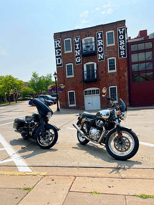
Our next stop was Red Wing, a town established in the 1850s to support steamboats moving up the Mississippi River toward vast available farmland. By 1873, Red Wing was a leading wheat producer, but it was eventually surpassed by Minneapolis where larger flour mills were built. Today the town is perhaps best known as the home of legendary boot maker Red Wing Shoes. The downtown St. James Hotel was founded in 1875 and has hosted U.S. presidents, Mark Twain, and other luminaries. Downhill from the hotel is the historic train station, which has old wooden benches and period signage on the walls. I could sit there all day watching the river roll by.
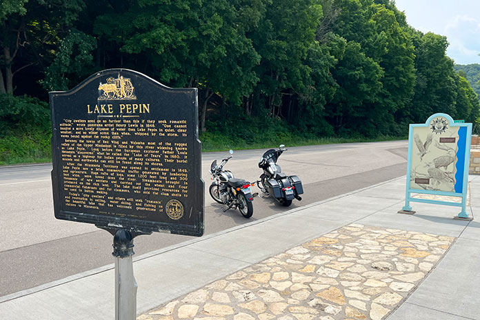
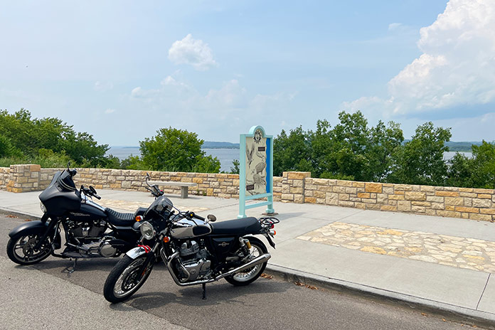
Continuing south, we visited Lake City, which sits on a wide stretch of the Mississippi called Lake Pepin, the birthplace of waterskiing. The lake was once a water highway used by Native Americans, and there are burial mounds and settlement ruins located nearby. Today, you’ll see raw materials being moved in barges and recreationists enjoying themselves in sailboats and ski boats.
Towering above both sides of Lake Pepin are distinctive limestone bluffs and tree-covered rock formations. With such unique scenery, it’s a challenge to keep your eyes on the road ahead. One minute you are feeling the heat from the tarmac and gazing up at high bluffs, and the next you’re ripping through dense maple forests enjoying the cool air and earthy smells. For golf lovers, the Lake Pepin Golf Course has 12 holes laid out atop the bluffs overlooking the Mississippi River Valley.
The bustling river town of Red Wing has many historic buildings, including the St. James Hotel, the old iron works, and the train station.
We arrived at the next small town on our route, Reads Landing, just in time for lunch. This was once considered as a potential capital city for Minnesota due to its booming lumber trade and strategic location on the Mississippi and Chippewa rivers. Reads Landing Brewing Company occupies an old red-brick building with an outdoor patio overlooking the river. It has a full menu and was a great place to cool off and relax.
Adding to the Great River Road’s natural beauty is an abundance of birds soaring overhead. The National Eagle Center in Wabasha houses permanently injured bald eagles and provides an opportunity for people to see these majestic creatures up close.
Lake Pepin has beautiful scenery and recreational opportunities, and it was the birthplace of water skiing.
As we continued south, we approached Winona, a vibrant college town that’s home to the Minnesota Marine Art Museum, which is located right on the river and exhibits artwork inspired by water. With a variety of dining and lodging options, recreational opportunities, live music, festivals, and shopping, Winona is a great destination for an overnight stay or weekend getaway.
Southeast of Winona, on County Road 7, is Pickwick Mill, one of the oldest flour mills in Minnesota, built in the mid-1850s. The mill was named by the area’s first postmaster, who was a fan of Charles Dickens and his novel The Pickwick Papers. During the Civil War, it produced 100 barrels of flour per day for the Union army.
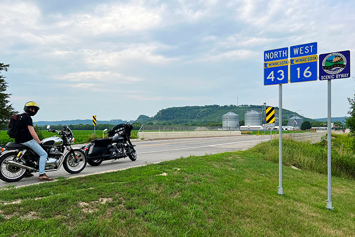
After returning to U.S. 61 and riding along the Mississippi to La Crescent, we turned west on the Historic Bluff Country National Scenic Byway (State Route 16). Even away from the river, bluff topography continues with hills and cliffs creating the winding roads we all live for. Through the towns of Hokah, Houston, and Rushford, we paralleled the Root River and the Root River State Trail, a rails-to-trails bike path linking the towns of Houston and Fountain.
After nearly 50 miles on the byway, we arrived in Lanesboro, an art, entertainment, and recreational hub where we spent the night. We stayed at the historic Hotel Lanesboro, which was built in 1872 from local limestone and is on the National Registry of Historic Places. Formerly a boarding house called Mrs. B’s, it once hosted Buffalo Bill and Doc Powell. The hotel is right on the main street with many good restaurants nearby. We had a tasty dinner at the Pedal Pushers Cafe, a nod to the many bicyclists who ride the state trail.
Overlooking Lake Pepin on the Mississippi River, one of many scenic stops on this southern Minnesota motorcycle ride.
My Harley is much louder than Chad’s Royal Enfield, and I felt guilty breaking the morning silence as we headed to the towns of Preston and Harmony. This area is Amish country, and it wasn’t long before we saw our first horse and buggy. Friendly and always good for a wave, the Amish are an interesting subculture. There are about 1,000 Amish in Harmony, and you can take tours to learn more about their way of life and visit shops with baked goods, furniture, and more.
Seeing a horse with buggy tied up at a local convenience store, I pulled a quick turn to stop and take a picture. Soon two young ladies with bonnets saw me as I attempted to pocket my phone, not wanting to look like a gawking tourist. They wished me a good morning as they untied their horse and climbed aboard to clip-clop down the road.
Harmony is also home to Niagara Cave, where you can take a tour 200 feet below the surface. It’s well worth it for this mile-long underground hike to see the various rock formations and even a subterranean wedding chapel.
We continued south on U.S. Route 52 to Prosper, a stone’s throw from Iowa, where we headed east and then north on State Route 44 to Caledonia, picking up State Route 76, which has twisties so enjoyable that we rode some sections twice. SR-76 took us north most of the way back to Winona, where we backtracked north on U.S. 61 to Wabasha. We then turned west on State Route 60 and joined a pack of bikers thundering in the same direction. Alongside the road is a lone sentinel, a skeleton biker that’s a reminder to keep the rubber side down.
The Historic Bluff Country National Scenic Byway (State Route 16) parallels the Root River and goes through small towns on its way from La Crescent to Lanesboro.
As we left the river and Bluff Country behind, the terrain flattened out as we made our way to Zumbrota, home of Minnesota’s last remaining functional covered bridge. Spanning the Zumbro River, the 116-feet-long, 15-feet-wide bridge was built in 1869 and looks like a long, red barn.
We rode northwest to Northfield, where in 1876, Jesse James and the James-Younger gang rode into town to rob the First National Bank. Facing pistols, the bank clerk refused to open the safe and was shot to death. Townsfolk retaliated, resulting in a shootout that killed another resident and a couple of gang members. The gang was pursued for 400 miles over the following weeks, eventually being captured in Madelia, Minnesota. Jesse James escaped, but his luck ran out when he was killed in 1882 by one of his own men hoping to collect a $10,000 reward.
We rode west to Henderson, which sits along the Minnesota River Valley National Scenic Byway, another favorite road. Henderson is an old river town with a historic downtown district that’s a fun place to visit.
Our Minnesota motorcycle ride through Bluff Country and along the Great River Road and other scenic byways gave us a taste of the history, beauty, and variety of southern Minnesota. The roads showcase some of the best riding, relaxing, and motorcycle-friendly places the state has to offer.
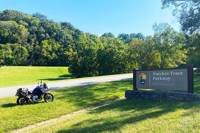
This Kentucky and Tennessee motorcycle ride includes a section of the Natchez Trace Parkway, which starts less than 20 miles from downtown Nashville. The historic road follows an ancient pathway for 444 miles to Natchez, Mississippi, on the Mississippi River. (Photos by the author and Cheryl Kessel)
When a family friend decided to celebrate a milestone birthday in Nashville, our interest was piqued. Being big music fans and suckers for seeing new places, especially those with famously good motorcycling roads, my wife, Cheryl, and I decided to tag along. Others handled the search for accommodations and entertainment opportunities for the trip, so I was left to handle the most important job: securing a motorcycle for some adventuring.
None of the rental companies in Nashville had a motorcycle that matched my criteria, so I searched the Riders Share peer‑to‑peer rental website and found a BMW F 750 GS. I had never used this kind of rental service before, and after some easy back and forth with the motorcycle’s owners, our rental was secure. The owners even agreed to deliver the bike directly to our lodging for a small fee. All we had to do was pack riding gear.
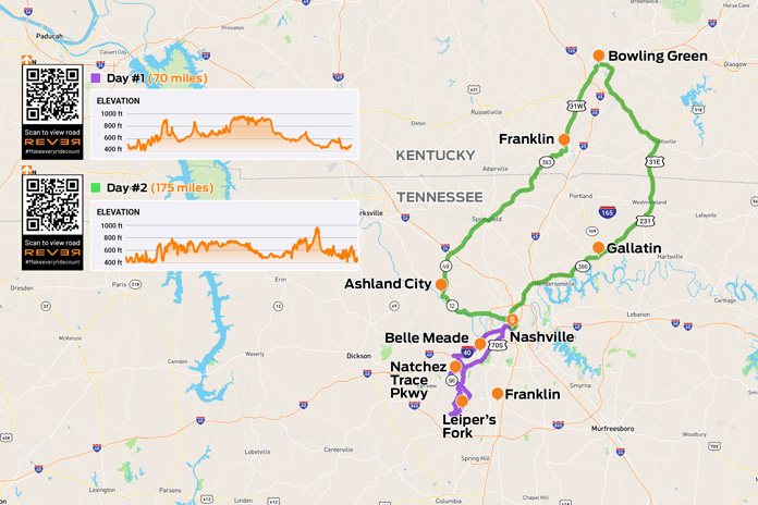
Scan QR codes above or click Day #1 or Day #2 to view routes on REVER
After a late‑night arrival in Nashville, we settled into our rental apartment downtown. About noon the following day, a clean, blue GS rolled up. The friendly owners, Madison and Tim, gave me some great local knowledge tips for our first afternoon of riding.
Day 1: Leiper’s Fork and the Natchez Trace Parkway | Tennessee Motorcycle Ride
We did not have time on this trip for the complete 444 miles of the famed Natchez Trace Parkway, but I knew we had to ride part of it. Tim gave me a strategy for seeing some great locations and sampling the parkway in an afternoon of riding. Nashville is a hive of tourist activity, and leaving the metro area went how you would expect. We weaved around party buses and through the dense traffic, finally leaving behind the neon lights, blaring music, and bar‑hopping activity for a Tennessee motorcycle ride through the countryside.
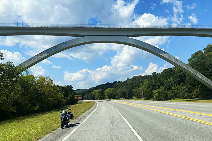
The 1,572-foot-long Natchez Trace Bridge is an impressive structure both from below and from above. It carries the Natchez Trace Parkway 145 feet above State Route 96.
We headed northwest on Interstate 40 through farmland and beside impressive southern mansions, both historic and modern. Our eyes, conditioned by the muted pastel hues of our home state of Arizona, were dazzled by the vibrant greens of the Tennessee landscape. After exiting the freeway at McCrory Lane, perfectly furrowed crops and geometrically mowed estate lawns lined the sweeping corners. On State Route 96, the Natchez Trace Bridge, with its sweeping, whitewashed double arches, grew on the horizon.
A bit more riding brought us to Leiper’s Fork. The quaint village, once a virtually unknown dot on a map, has emerged as a small, thriving arts and entertainment center. It is also near sprawling estates owned by music and entertainment superstars like Faith Hill, Tim McGraw, and Nicole Kidman.
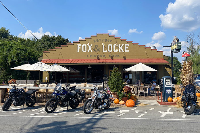
On the town’s short main street, we dropped a kickstand at the Fox & Locke Restaurant, a historic establishment with a common feature at any bar or restaurant in this neck of the woods: a stage for live performances. Cheryl ordered the classic BLT, and I chose the catfish sandwich – flaky white fish topped with a medley of slaw, grilled onions, and pickles – which was a culinary highlight of our entire vacation.
The Fox & Locke in Leiper’s Fork, Tennessee, is a favorite stop for motorcyclists near the Natchez Trace Parkway.
After a walk by the shops and galleries of the small town, we rode onto the Natchez Trace Parkway. It was almost surreal how the traffic dropped away, the road became smooth, and the terrain morphed into an undulating delight. Mowed grass lined the sweeping corners of the parkway, and wooded thickets added to the texture of the ride. I did not have to slow for traffic once on our way to the Parkway’s northern end, which included riding over the massive bridge that we rode beneath earlier. The entirety of the Natchez Trace is now on my bucket list of rides.
After exiting the Parkway, we passed another famed local eatery, the Loveless Cafe, but I was too full from lunch to indulge in their legendary biscuits and gravy. We made our way to the Belle Meade Estate and Winery for a brief tour of the historic property before rolling back into Nashville.
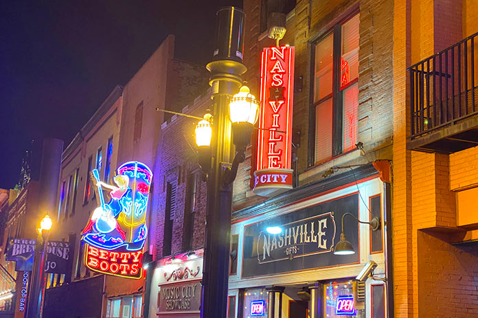
Nashville is a nonstop mix of neon, live music, and bustling watering holes.
We spent the night sampling what has made Nashville famous – music. I doubt there’s a Broadway Street music hall that we did not visit. Night clubs sporting the names of famous country stars teemed with tourists as music blared from every direction. Multi‑leveled bars offered performers on each floor. We opted for the rooftop settings as they tended to be less intense and crowded. Far from a lazy Southern city, Nashville is a frenzy of people and music often referred to as “Nashvegas.”
Day 2: Burning Barns and Bowling Green | Kentucky Motorcycle Ride
With country music still ringing in my ears, I geared up for a solo ride north of Nashville as Cheryl opted to sleep late. I headed northwest toward Ashland City on State Route 12, a smooth and pleasant roll through sweeping corners on a road which lived up to its designation as a state scenic parkway. From Ashland City, I made my way onto State Route 49 on a northeastern path toward Kentucky.
I was fully engulfed in farmland. End‑of‑season cornfields dried in the September sun, and various other crops were green and thriving. An unexpected sight led me to stop and reach for my cellphone. Smoke was wafting from the gables and overhangs of a large red barn. I could not help but think about the short story “Barn Burning” by one of my favorite Southern authors, William Faulkner. Just before I did my civic duty by calling 911, I noticed another barn on the horizon emitting the same white smoke. A quick Google search set me straight.
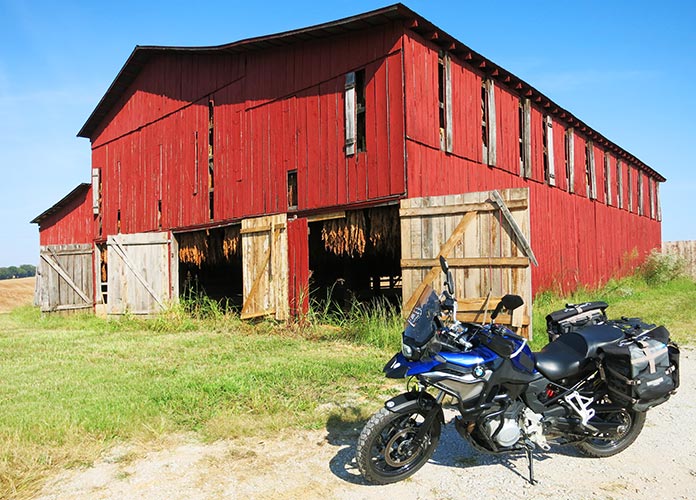
As it cures, tobacco hangs like giant bats in a Kentucky barn.
It was tobacco curing season, and farmers were drying their crop at 135‑140 degrees with carefully controlled fires within those barns. What was, at first, a concerning sight was now a source of intrigue and education for this Arizona boy. After passing by those smoldering structures, I saw another type of tobacco curing: huge red barns had doors opened wide, and tobacco hung from ceilings. If I hadn’t already done my roadside research, I may have mistaken the tobacco leaves for drying animal hides.
The ride through farmland continued as I passed from Tennessee into Kentucky, another tobacco‑producing state. The road carried new signage as Kentucky Route 383. I rolled into Franklin, a historically rich small city with a beautiful brick and stone downtown area, where Johnny Cash and June Carter were married at the First United Methodist Church. There is much to do in Franklin: thoroughbred racing and gaming at The Mint at Kentucky, tours and live dueling reenactments at the Sandford Duncan Inn, and Kentucky’s largest sunflower maze in August at Ruby Branch Farms. Kentucky is famous for its whiskey, and the Dueling Grounds Distillery is on the Kentucky Bourbon Trail Craft Tour.
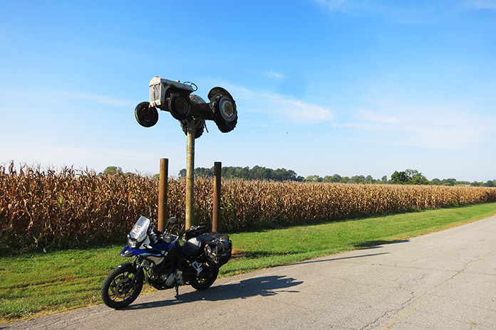
A farmer took his tractor to new heights in the region’s rich farmland.
On my way out of town, I stopped at The Fork In The Road, an art installation of a Paul Bunyan‑sized utensil located at the corner of Bunch and Uls roads. Continuing north on U.S. Route 31W toward Bowling Green, I passed Octagon Hall, an eight‑sided brick home built in 1847 that is now a museum of Civil War artifacts.
Bowling Green is not just a bustling and vibrant Southern city; it is also the only place in the world where Corvettes are made. I rode past and beside several of the sleek Chevys as I made my way through the city, which is also home to the National Corvette Museum. I motored through the attractive Western Kentucky University campus with its white‑columned and red‑brick buildings. The campus also preserves several historic structures like the impressive Felts Log House, which was built by a Revolutionary War veteran around 1810 and relocated to its current location in 1980.
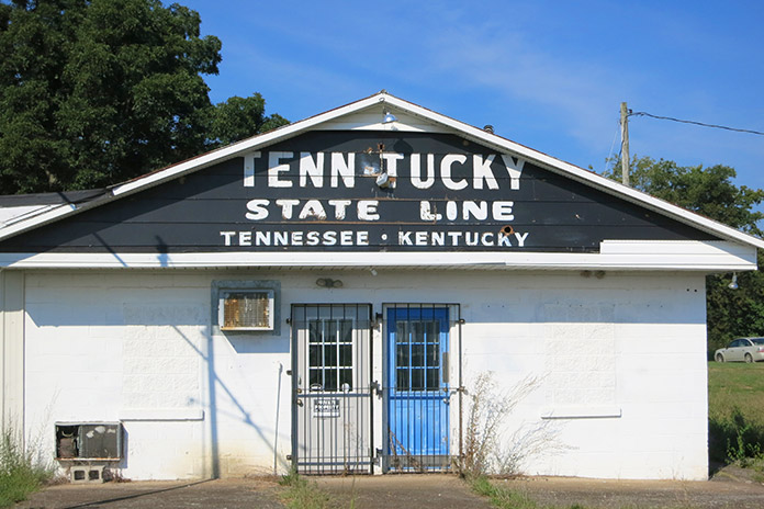
This unassuming building squats directly on the Tennessee/Kentucky state line.
After WKU, I made my way to the downtown district. The town square is a lively city centerpiece. A garden‑like central park sits in the shadows of historic stone buildings, and a beautiful fountain sits as the heart of the setting. My walk around the city center included several historically significant buildings and memorials. The area is well worth a visit.
The quick route back to Nashville from Bowling Green would be Interstate 65, but where’s the fun in that? I rode U.S. Route 231 south through southern Kentucky and northern Tennessee until I made the southwestern turn onto U.S. Route 31 toward Nashville. It was a nice, relaxing end to my “exposure” of this part of Tennessee and Kentucky. We ended the night back on the streets of Nashville, visiting the famed Ryman Theater, listening to country music, and sampling Tennessee whiskey.
The beautiful town square in Bowling Green, Kentucky, is a great place to drop a kickstand and stretch the legs.
Nashville, Bowling Green, and the other smaller towns I visited all exuded their own Southern charm. This was my first visit to the area, and it won’t be my last. I plan to ride the entire Natchez Trace Parkway, and the Nashville area will be either the staging location or the end game to that journey.
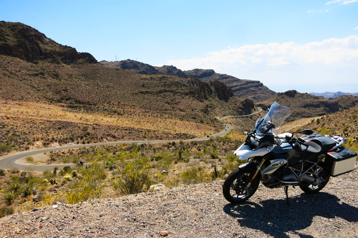
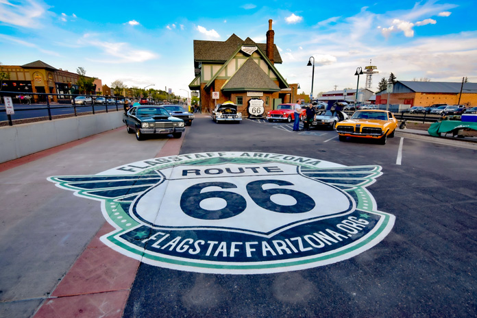
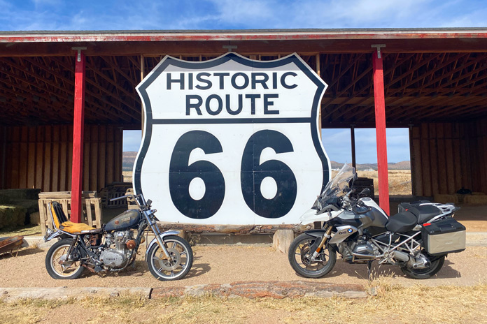
Riders enjoy the winding asphalt on this Route 66 motorcycle ride outside of Oatman.
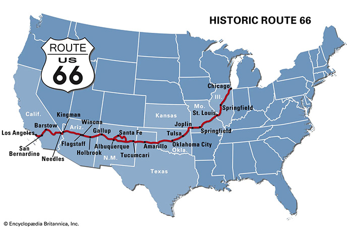
Route 66, or the Mother Road, is indelibly stitched into the fabric of the American psyche. The iconic road once traced its way for 2,448 miles from Chicago, Illinois, to Santa Monica, California. But it was more than just a long stretch of tarmac. Route 66 became a cultural phenomenon that inspired and piqued the American obsession with travel and adventure. Songs were written about it, quirky and kitschy roadside attractions sprouted beside it, and Americans longed to traverse it. The Mother Road was a main artery crossing the torso of the U.S. through which dreams and possibilities pulsed warm and red.
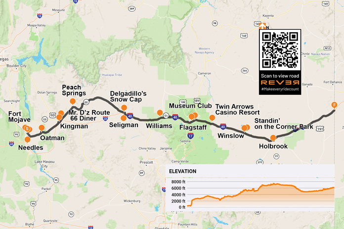
Yearning to rediscover the road, the towns, and the magic of Route 66’s path through Arizona, I packed up my BMW R 1200 GS and set out. Fittingly, my trek began Nov. 11, the date on which the Mother Road was designated a federal highway in 1926. Arizona claims the longest rideable portion of the original Route 66, and it has a significant number of attractions and bustling historic towns.
Riding from west to east, I began my Mother Road adventure on the Fort Mojave Indian Reservation where the Colorado River separates Arizona from Nevada. After a short climb toward the mountains on Boundary Cone Road, I came to an intersection indicating that I was transitioning onto the historic U.S. Route 66. The road became curvier and more interesting, and the jagged rock formations of Arizona’s Black Mountains became more immediate as the road coiled through the rugged terrain.
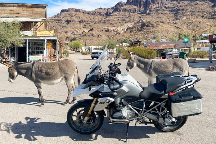
Friendly burros in Oatman weren’t impressed with my BMW beast of burden.
Within minutes, I entered the historic mining town of Oatman. In 1915, two miners struck a $10 million gold find. Within a year, the small mining camp grew to a population of 3,500. Recent census figures indicate there are now just over 100 human residents. If you include the dozens of semi-wild burros in the area, that population is much larger.
Oatman is a hotbed of activity during any motorcycle rally on the Colorado River or in Kingman. However, my BMW was one of only two motorcycles in town on this crisp November morning. I walked the street beneath the weathered wood facades of the various shops and watering holes.
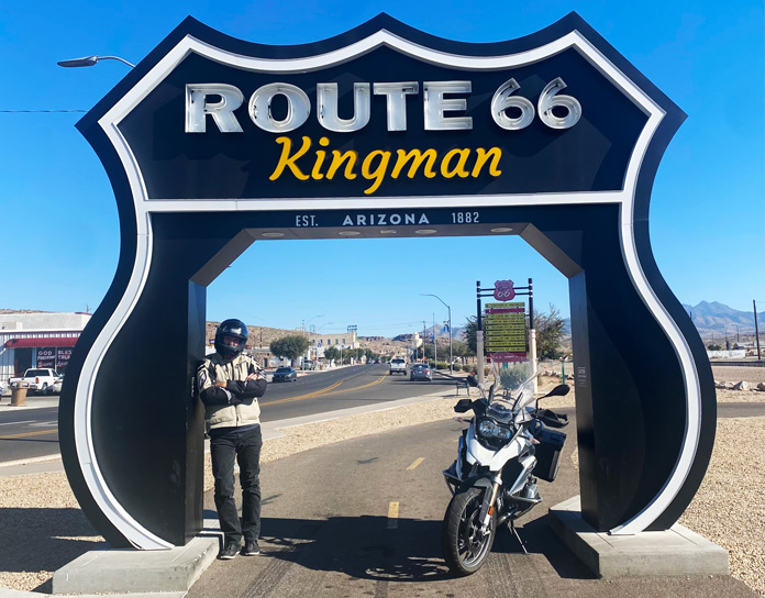
This ride-through photo stop in Kingman is located next to the Arizona Route 66 Museum.
Route 66 north and west of Oatman is a pure delight. The pavement is mostly smooth and intact, and it’s filled with sweeping turns and hairpins, many of which are nicely banked. There are several signs warning motorcyclists to stay aware, and these are best heeded. With the road gradually uncoiling, I made my way toward Kingman, passing several abandoned open-pit mines that dotted the rocky slopes and at least one small operating mine.
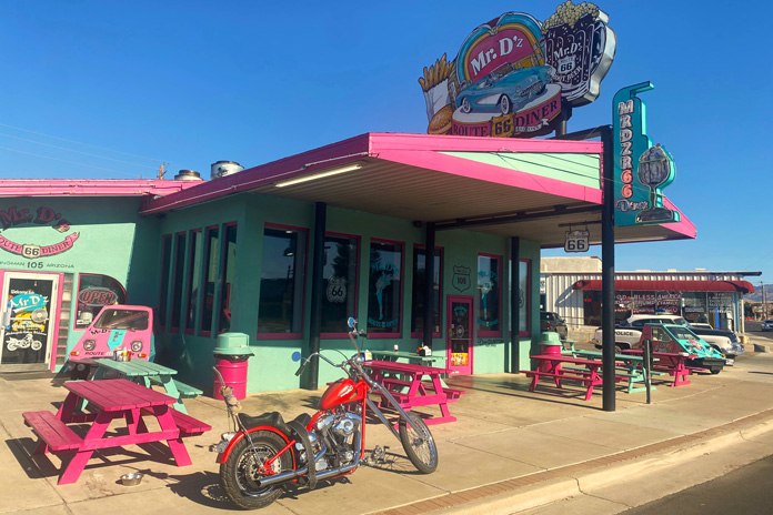
I was ready for a cup of coffee and some gas when I rolled into Kingman, where my father was an art teacher in the local school district before I was born. It is a clean and bustling small city fully embracing its Route 66 roots. I stopped at the colorfully adorned Mr. D’z Route 66 Diner and parked amidst historic cars, trucks, and motorcycles. As I chatted with my server over a hot cup of joe, she talked about the dual nature of the city. We were in the historic downtown district, but just a little ride up Interstate 40 is the modern district with chain hotels, restaurants, and thriving industry.
Across the street from the Route 66 Kingman sign is Mr. D’z Route 66 Diner, one of the many kitschy restaurants along the Mother Road that draw in curious, hungry travelers.
After rolling through the industrial zone in the Kingman outskirts, I headed northeast on the longest existing stretch of the Mother Road. Small roadside businesses dotted the path toward Peach Springs, each clearly embracing its Route 66 heritage with appropriate signage and vintage memorabilia. Historic gas stations were particularly interesting. While they no longer pumped fuel, they still oozed with the nostalgia of the road’s heyday.
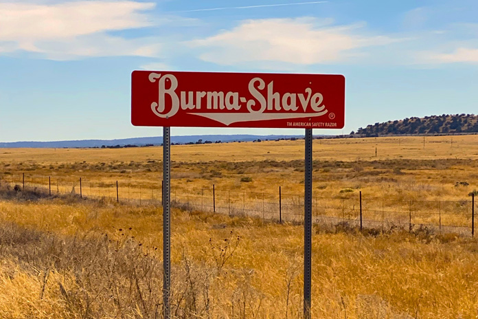
Between Peach Springs and Seligman: You can drive / A mile a minute / But there is no / Future in it / Burma-Shave.
After Peach Springs, I rode past three sets of Burma Shave signs with rhyming slogans, reminding me of childhood. As I rolled and swayed through the high grasslands, it was easy to imagine classic cars and motorcycles plying this portion of the route.
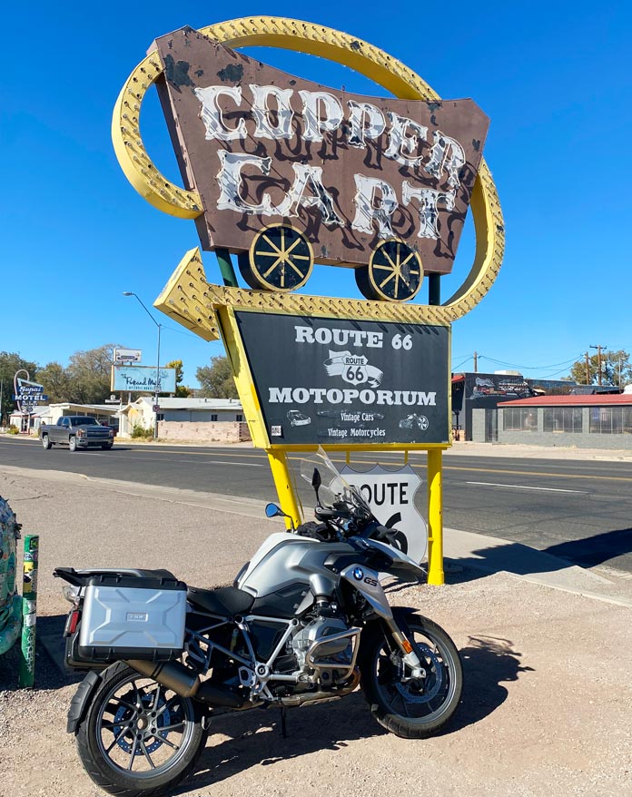
Formerly a restaurant that opened in 1952, the Copper Cart in Seligman is now a gift shop.
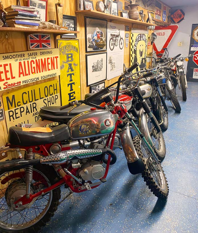
Entering Seligman was the most visually nostalgic part of my ride. This small town is a well-preserved tribute to its Route 66 heritage, with every shop, garage, and diner adorned with colorful signage and logos. Out of the corner of my eye, I saw a small sign for the Route 66 Motoporium. Not expecting much, I threw down my kickstand and walked into the Copper Cart to see what was inside. A bearded man said, “You look like a rider,” and pointed to a room in the back. It was filled with the motorcycles of my youth – both those that I rode and those that I ogled in the pages of motorcycle magazines of the 1960s and ’70s. Vintage Indians, Hondas, Hodakas, and Kawasakis, especially the 2-strokes, brought me back to the enchanting smell of premix laced with single-track dust that was a big part of my teenage life.
The Copper Cart in Seligman is home to the Route 66 Motoporium, a small museum full of vintage motorcycles and memorabilia.
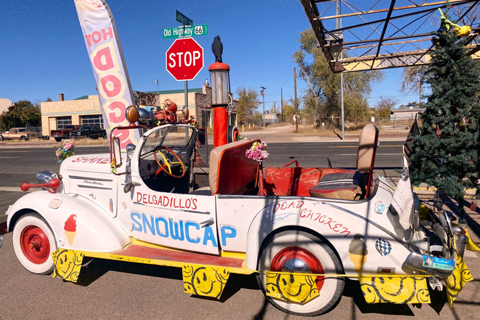
After a lengthy trip down moto-memory lane, it was time for lunch, and the legendary Delgadillo’s Snow Cap diner was just a block away. Juan Delgadillo and his wife, Mary, opened the Snow Cap in 1953, and Juan and his brother Angel formed the Historic Route 66 Association of Arizona. The Delgadillo family still owns and runs the historic diner, and I had a fantastic green chili burger and onion rings.
This 1936 Chevy is an eye-catching fixture in front of Delgadillo’s Snow Cap diner, a Route 66 institution in Seligman opened by Juan and Mary Delgadillo in 1953.
East of Seligman is a short stretch of the original Route 66 that runs into I-40 just before Ash Fork, and I noticed a few remnants of the Mother Road that are now spurs off the roadway. Beyond Ash Fork, much of Route 66 has been fully replaced with I-40, but there are still several towns that have embraced and preserved their historic Mother Road character.
Route 66 runs through the heart of Flagstaff, a bustling city with great restaurants, bars, hotels, and nearby attractions like the Grand Canyon.
Williams, just off I-40, was the last town to be bypassed by the interstate, and it still teems with Route 66 charm. The main street is lined with historic stone buildings filled with antique stores, diners, and bars. I motored by one of the more famous watering holes, the Sultana Bar, which was opened in 1912, predating Route 66 by more than a decade.
After Williams, I-40 is as attractive as an interstate can be. Views of the San Francisco Peaks tower impressively to the north, and vibrant evergreens line the road. Flagstaff is the largest city on the Arizona portion of Route 66 and is home to my alma mater, Northern Arizona University. The original Route 66 skirted the beautiful campus just to the west and north.
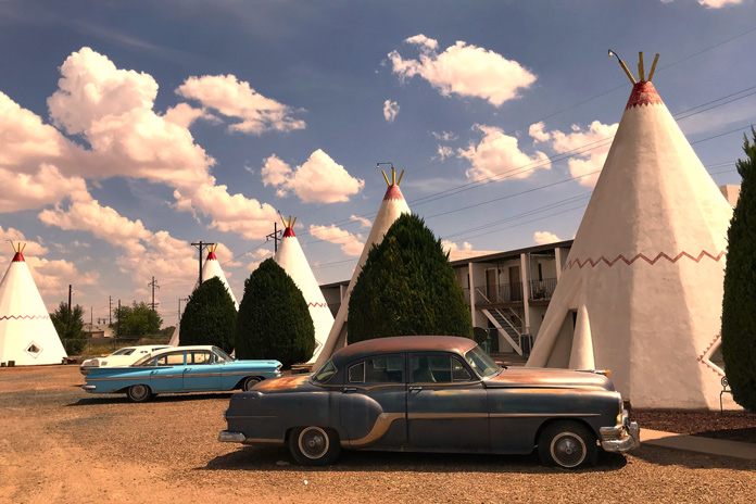
Built in 1950, the Wigwam Motel in Holbrook is a Route 66 icon.
Flagstaff boasts several original Mother Road attractions, including the historic downtown train station that houses the Flagstaff Visitor Center. On the way out of the city, I rolled past several diners that boast the Route 66 name, but my favorite is Miz Zip’s Route 66 Cafe. Then I felt the magnetic pull toward the Museum Club, an iconic Route 66 watering hole and one of my favorite college hangouts.
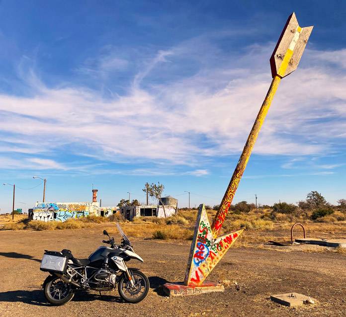
The majority of Route 66 east of Flagstaff has been replaced by I-40. While that is a shame, there is solace in the fact that many of the original attractions of the Mother Road era are still partially or fully intact on the way to the Arizona/New Mexico border. I took the short access road to the ruins of the Twin Arrows Trading Post. Up until very recently, both twin arrows still stood, but the ravages of weather and time toppled one. The trading post was a fixture on Route 66 since its opening in the late 1940s. Just across the freeway looms the new Twin Arrows Navajo Casino Resort.
Alas, only one arrow is still standing at the ruins of the Twin Arrows Trading Post between Flagstaff and Winslow.
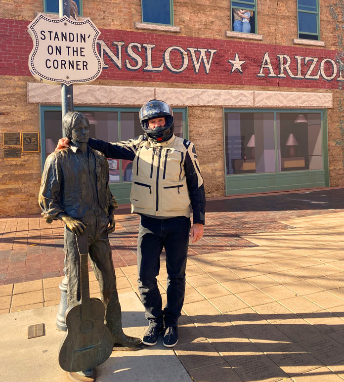
Riding another 30 minutes east on the interstate, I exited at Winslow, which sits on another existing stretch of Route 66. The loop into Winslow is festooned with various Route 66 advertisements. My first stop in town was to look at the impressive red sandstone St. Joseph’s Catholic Church. After snapping a photo at Standin’ on the Corner Park, I saddled up and headed to my lodging for the night, the beautifully restored La Pasada Hotel (see sidebar below).
At Standin’ on the Corner Park in Winslow, Arizona, the author stands with a bronze statue of a balladeer resembling Jackson Browne, who co-wrote the famous Eagles’ song “Take It Easy” with Glenn Frey.
After settling into my room, I walked the grounds of the beautiful rail-side resort before sitting with a post-ride cocktail and watching the trains roll by. Later that night, I strolled back into downtown Winslow for some shopping and a chili relleno dinner at the tiny Brown Mug Cafe. An unassuming photo on the wall beside my booth showed a youthful Harrison Ford sitting in the same spot many decades back (he’s an avid motorcyclist, by the way, and also owns a GS!).
Some motorcycles you’ll find on Route 66 have seen better days.
After a great night’s sleep, I had one last stretch to complete my Arizona Route 66 tour. I rode the few miles to Holbrook, which is the last of the original historic towns on my eastward stretch of Route 66 and home to the Wigwam Motel. From Holbrook, it’s another 74 miles on I-40 to the New Mexico border.
I highly recommend riding what you can of any portion of the Mother Road. This Arizona stretch of Route 66 is best ridden from late spring to early fall, as the winters in northern Arizona are cold and snowy. Pack for variable conditions, and enjoy your ride down memory lane.
La Posada in Winslow is a crown jewel of the historic Fred Harvey railroad hotel empire. Designed in the 1920s by renowned architect Mary Elizabeth Jane Colter, it’s currently a first-class hotel, art gallery, and museum in an expansive garden setting. There is a gourmet restaurant on-site, and downtown Winslow is a short stroll away. The rooms are comfortable and well-appointed in a warm Southwestern motif, and photos of the hundreds of legendary actors and public figures who stayed at La Posada line the hallways. There is even safe designated motorcycle parking in front of the property. For more info, visit the La Posada website.
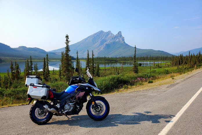
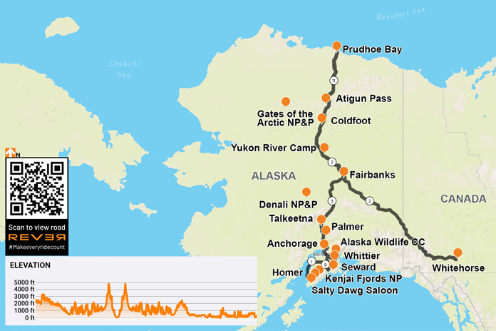
On the Dalton Highway, Sukakpak Mountain rises 4,390 feet and reflects in the Koyukuk River. Sukakpak is an Iñupiat word meaning “marten deadfall” because, seen from the north, the peak resembles a carefully balanced log used to trap marten. (Photos by the author)
It wasn’t that she was a princess. She had lived and taught on a reservation in northern Ontario where she gutted geese, chopped down trees, and drove on the ice roads. But by her own admission, my partner, Steph, was a sun ‘n’ sand type of vacationer. Riding and wild camping with no electricity was not her idea of a good time. And a hostel? Forget it. So when the opportunity arose for an Alaska motorcycle ride – taking my Suzuki V‑Strom 650 from Niagara Falls to America’s last frontier – my suggestion that she fly to Anchorage and meet me…well, it wasn’t flying.
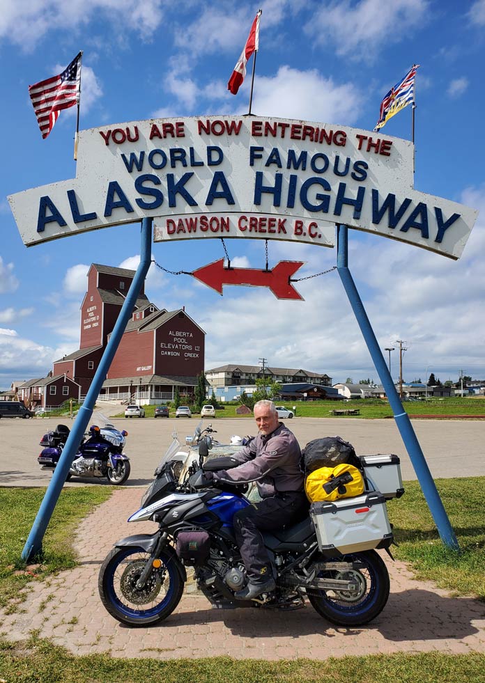
Built by the U.S. Army for defense from the Japanese in WWII, the Alaska Highway opened the secluded northwest to travel and trade. In the background, the only wooden grain elevator remaining in Dawson Creek, British Columbia, reopened in 1983 as an art gallery.
But over the weeks – and from over my shoulder – the more she saw of my reading and planning and YouTube videos, the more curious she became.
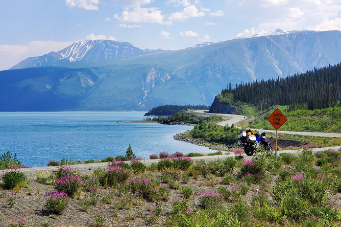
My late June ride across the Canadian prairies and into northern British Columbia had been an adventurous mix of wind and rain and heat so unbearable that I spent a full day in a rundown Saskatchewan hotel to recover in air‑conditioned bliss. But it wasn’t until I reached the Alaska Highway west of Haines Junction, Yukon, that I began to wonder if my riding skills would be up to the task.
The entire 200 miles to the Alaskan border was a constantly changing mix of gravel, chipseal, and potholes, with just enough pavement to inspire complacency. Most disconcerting were the unannounced depressions caused by permafrost. Without warning, the bike would simply drop away beneath me, only to come pounding back like an unbroken bronco. Twice I was certain I was going over the handlebars. Almost as unnerving were the lengthwise ridges that attempted to grab my tires and toss me off the road.
The Alaska Highway threads its way between Kluane Lake and the Kluane Mountains near Destruction Bay, Yukon. The entire 200 miles from Haines Junction to the Alaska border was an adventure in itself.
Between the irregular road surface and the wildlife, I was in no danger of nodding off. At one point, I was negotiating a corner on the loose surface when a large moose bolted into my path from the alders on my right. Brakes were almost useless in the gravel. She was so startled that she was still peeing as she charged in front of me, and I admit I checked myself for the same once she had disappeared into the brush. It wasn’t long before I encountered a grizzly and then a caribou on the shoulder, but they at least seemed content to stay put.
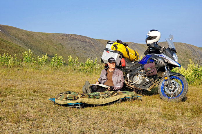
Wild camping on the Top of the World Highway near Poker Creek, Alaska.
The pavement improved measurably near Tok. In Yukon River Camp, where I fueled up for the long ride on the Dalton Highway to Prudhoe Bay – one of the “most dangerous roads in America” – I partnered up with another solo rider for mutual support should the trip go (quite literally) sideways. With no shoulder and with roadsides that often plummet 50 feet to the soggy tundra, one of the greatest dangers of the Dalton is unexpectedly becoming the focus of a search party. But the weather gods smiled on us. A sprinkling of rain the day before had dampened the notoriously blinding dust without creating the slippery, muddy mess I had feared. And I marveled at the midnight sun, which kept temperatures between 35 and 60 degrees.
While camping on the Top of the World Highway near Poker Creek, Alaska, the author was awakened by an enormous herd of Porcupine caribou passing by.
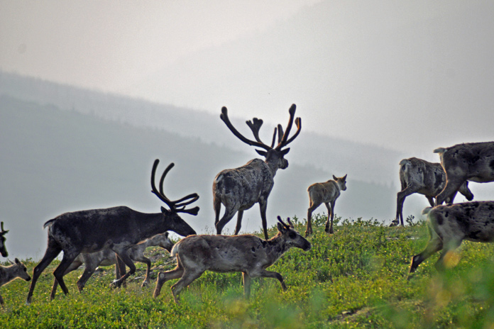
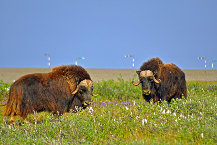
After a night of primitive camping – and a surprisingly good meal – in Coldfoot, my riding partner and I spent a full day navigating the dirt and ogling the views: from the omnipresent Trans Alaskan Pipeline to the enormity of the Brooks Mountain Range and Atigun Pass, to the endless sweep of tundra on the North Slope toward the Arctic Ocean. And of course, the muskoxen we encountered as they munched on moss and lichens. Needless to say, high‑fives and a toast were in order two days later when we successfully returned to Fairbanks. This was adventure on a new scale.
Just east of the Dalton Highway (aka the “Haul Road,” which runs from just north of Fairbanks to Prudhoe Bay), muskoxen roamed the windy tundra of the North Slope near the Sagavanirktok River. They live naturally only in the Canadian arctic tundra, Alaska, and Greenland. Members of the goat family, their underwool is eight times warmer than sheep’s wool yet surprisingly light.
Rolling into Anchorage, on the other hand, I was struck by how much the city was like any other. In fact, locals joke that the best part about Anchorage is that in under an hour, you can drive to Alaska. I searched out the House of Harley‑Davidson, which offers riders free camping (including restrooms and showers), and awaited Steph’s arrival.
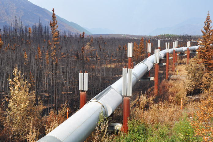
The Trans Alaska Pipeline runs 800 miles from Prudhoe Bay to Valdez, a port near the Gulf of Alaska, and was engineered to shift with the permafrost, withstand forest fires (as it has done here), and adapt to temperature changes of 180 degrees F (the pipeline lengthens by almost 6 feet in summer heat).
It was a little discouraging the next morning when her flight brought with it a cold front full of clouds and rain. But I was grateful she had come and determined to make the most of our 10 days together. On the way to Flat Top Mountain for a panorama of the city, we rolled along Cange Street, which doubled as an airport runway. Each home had its own attached hangar, and prop planes were parked on several front lawns. On another city corner, we encountered a moose that casually browsed a willow before sauntering across a driveway and into a backyard.
Staring down the Dalton: Is that a smile or grimace?
South of town, the Seward Highway hugged the narrow shore between the steep Chugach Mountains and the churning waters of Turnagain Arm. At Beluga Point, we paused to watch the tidal bore, a daily surge of seawater that can be over 3 feet high and sounds like a freight train. The tides themselves, rising to 35 feet, rival those of the East Coast’s Bay of Fundy. Naturally, we had to visit the nearby Alaska Wildlife Conservation Center where injured animals are rehabilitated. It was one place where we were guaranteed to see most of Alaska’s wildlife up close.
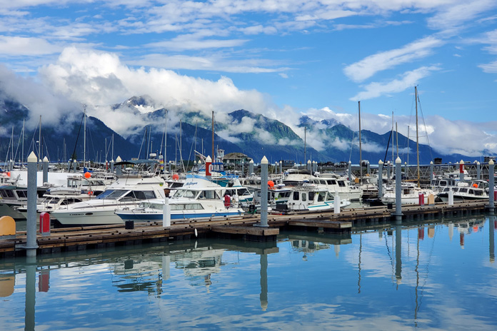
Seward Boat Harbor, on Resurrection Bay, is merely an introduction to the beauty in store on the Kenai Peninsula.
Believing that my intrepid partner deserved at least one nice hotel, I had booked a “glacier view” suite in the port of Whittier. This came with the bonus of riding through North America’s longest tunnel, a single‑lane route that runs 2.5 miles under an entire mountain. Besides a fish-processing plant, however, Whittier has only two large buildings, both of which are remnants of World War II: an abandoned military supply post and an apartment building that houses nearly the entire town’s population. Without even a pretense of renovations, the top floor now serves as a hotel.
Our apartment, while clean, was clad in 1960s paneling, and the bathroom was adorned floor‑to‑ceiling in pink tile. Most bizarre was the multitude of safety bars (I counted 10) fastened to the wall in the shower. Steph had started calling it the “Bates Motel,” and I suggested the handles were for grabbing when Norman dropped by. On top of that, not only was the rain incessant and obscured the view of the harbor from our window, but when we asked about the glacier, we were told we’d have to sail 6 miles out of port and around a mountain to get a glimpse. Alaskans also joke that “Everything is sh*ttier in Whittier,” and we just had to laugh.
Wading into the icy waters of Prudhoe Bay on the Arctic Ocean.
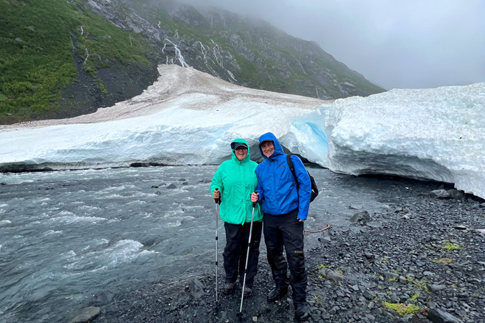
However, if our night had been a low point, the next morning was a decided high. Wearing our raingear and carrying a set of hiking poles, we set out to explore Byron Glacier. Dense forests gave way to alder thickets that soon opened to lichen‑dotted boulders. Under a steady rain, we climbed the rugged upper valley where ice lay covered in black silt. Towering high above, the jagged peaks were trimmed in white fondant while sinuous waterfalls tumbled from the sheer cliffs. Ahead, shining and motionless, the bright blue glacier stood before us, a frozen river imperceptibly carving out the valley floor. Dwarfed in this vast, timeless amphitheater, we seemed no more than fleeting specks, and tears welled up in Steph’s eyes. This was travel on a new scale.
After a cozy night in a warm log cabin, we continued to Seward where we joined a day‑long boat tour of Kenai Fjords National Park and Resurrection Bay, a rich marine ecosystem with craggy coves, deep fjords, and tiny treed islands. Every wildlife sighting brought a new gasp: Sea lions, otters, puffins, murres, and mountain goats were but a prelude to the humpbacks, fin whales, and orcas. Bald eagles watched us from branches along the shore.
Approaching Atigun Pass from the north on the Dalton Highway, the author pauses beside the Sagavanirktok River.
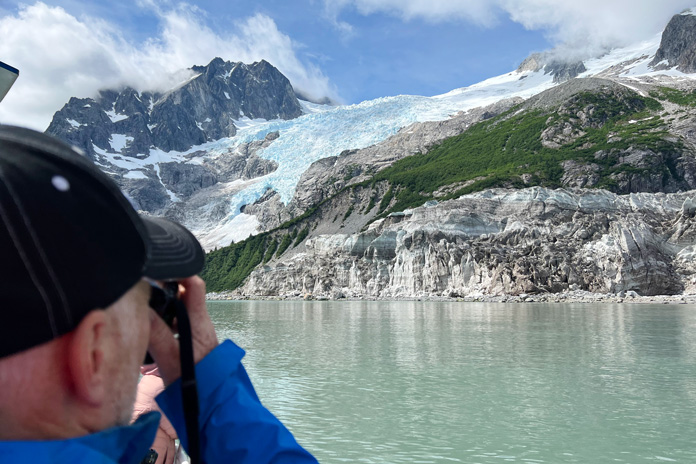
Most stunning of all was Northwestern Glacier at the head of the fjord. As a million tiny ice chunks bobbed around our boat like warning buoys, we drew ever closer and were overwhelmed by its size and the thunderous calving. The splitting columns sent booming explosions reverberating off the cliffs, followed by great walls of ice crashing into the frigid water. We stood gripped in a hallowed silence.
Arriving in Palmer the following day, we explored the Matanuska Valley, a region with a surprising claim to fame. Particularly fertile soils and summer days with 22 hours of sunlight produce record‑setting vegetables: cabbages bigger than beach balls, carrots the size of small logs, and pumpkins that must be lifted by crane. As one resident told me, “We get just as much sunlight as anywhere else – we just get it all at once.”
The author and his partner, Steph, hiking Byron Glacier.
Along the Knik River, we were introduced to glamping in a huge canvas tent with a queen‑sized bed, an upholstered chair, and more pillows than a palace. It was a far cry from my bivy sack – and just what Steph had wanted.
Morning was a little brighter as we set off for Homer, a small town on the southwest side of the Kenai Peninsula. Twisting through wooded Cooper Landing and Soldotna, the Sterling Highway turned south and followed the coast along Cook Inlet. From Clam Gulch, we skirted the edge of the cliffs all the way to our destination. When keeping my eyes on the road became impossible, we pulled over and tramped through a field to the precipice, where we could see Sadie Peak across sparkling Kachemak Bay standing in snow‑covered glory high in the equally glorious Chugach Mountains.
Northwestern Glacier is one of many photo ops at every turn in Kenai Fjords National Park.
The only thing I knew about Homer was that the Salty Dawg Saloon was perched on the end of a spit. As old as the town itself, the diminutive building has served as a school, post office, railway station, and grocery store. In 1957, it became a saloon, and shortly thereafter, as the story goes, a patron who’d grown tired of waiting for his friend stuck a dollar bill to the wall for him to buy a drink if he ever showed up. The ensuing tradition has resulted in every surface being completely papered in dollar bills. Unable to find room for my own bill, I wedged a Loonie (a Canadian dollar coin) into a picture frame and apologized (equally Canadian) to the bartender for my 76‑cent contribution.
Thirty minutes east of Homer, we bounced down a rutted dirt road to our accommodations on the Kilcher Family Homestead. In the early 1940s, professor Yule Kilcher left war‑torn Switzerland to find peace in the wilds of Alaska, where he and his wife built a log cabin and raised eight children. Living a subsistence lifestyle and clearing fields, the family eventually acquired 600 acres, where they continue to live off the land.
Stellavera’s garden-shed-turned-lodging on the Kilcher Family Homestead.
You have undoubtedly heard the music of Jewel, one of the Kilcher grandchildren, and may even have seen episodes of their Discovery Channel series, Alaska: The Last Frontier. One daughter, Stellavera, lives off‑grid in a yurt near the cliffs and converted a garden shed into a surprisingly enchanting Airbnb. Enclosed in clear corrugated roof panels and furnished with a queen bed, heater, and lots of books, the structure – and the outdoor shower – gave us stellar views of Kachemak Bay and the ice‑glazed mountains beyond. It was spectacular.
Before we knew it, we had to return to Anchorage, where I needed to do some scheduled bike maintenance and Steph caught a flight home. The weather had deteriorated the day she arrived, and although it never kept us from the many activities we had planned, we joked that the sun would return the day she left. That is exactly what happened. Under a clear blue sky, I rolled out my bivy again, anticipating the next leg of the journey and happy to have spent 10 days with Steph in a land unlike anything we had ever known. She still loves the beach, of course, but now all she can talk about is when we can go back to Alaska, where wonder is on a new scale.
Fireweed adds vibrant color to the cliffs facing Sadie Peak on the far side of Kachemak Bay near Homer.
John Alger rides the historic U.S. Route 66 from Chicago, Illinois, to Amarillo, Texas, on his kickstart-only 1978 Yamaha SR500.
Dubbed the “Mother Road” by John Steinbeck in The Grapes of Wrath and known as “Main Street USA,” U.S. Route 66 will celebrate its 100th anniversary in 2026. No other road in America had such an impact on growth, migration, transportation, and popular culture. During the Great Depression and the horrific Dust Bowl of the 1930s, Route 66 was a paved pathway to a better life, transporting tens of thousands of people from the heartland to the West.
Map of Route 66 courtesy of Encyclopedia Brytannica
Right after WWII, my Uncle Don traveled from California to his hometown of Springfield, Illinois, using much of Route 66 and riding a kickstart, air-cooled, single-cylinder AJS. As I pondered my own journey on the Mother Road, it seemed fitting to attempt it on my 1978 Yamaha SR500, which is also an air-cooled, kickstart Single. Over the years, I have owned several Yamahas, but the SR500 has been my preferred ride for its light weight, effortless cornering ability, competent disc brakes, and simple but elegant design. I like it so much, I own two.
The author’s 1978 Yamaha SR500 on Route 66 in Tulsa, Oklahoma.
For my trip, I chose the one with 30,000 miles on the odometer. Except for upgraded brake hoses, it was bone stock. To get it ready for my Route 66 adventure, I gave it a complete engine and chassis overhaul, as well as a 535cc big bore kit, an oil cooler, and a SuperTrapp exhaust. I retained the stock air box and K&N air filter but re-jetted it as required. The new chain and sprockets were one tooth larger on the countershaft, which lowered cruising rpms and resulted in a mostly vibration-free ride.
The SR500 also has a no-frills CDI ignition system with a strong charging system, allowing me to keep my cellphone and Bluetooth full of juice, and a centerstand, a must-have for daily chain lubrication and fixing flat tires (I had one).
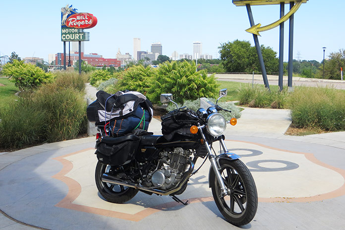
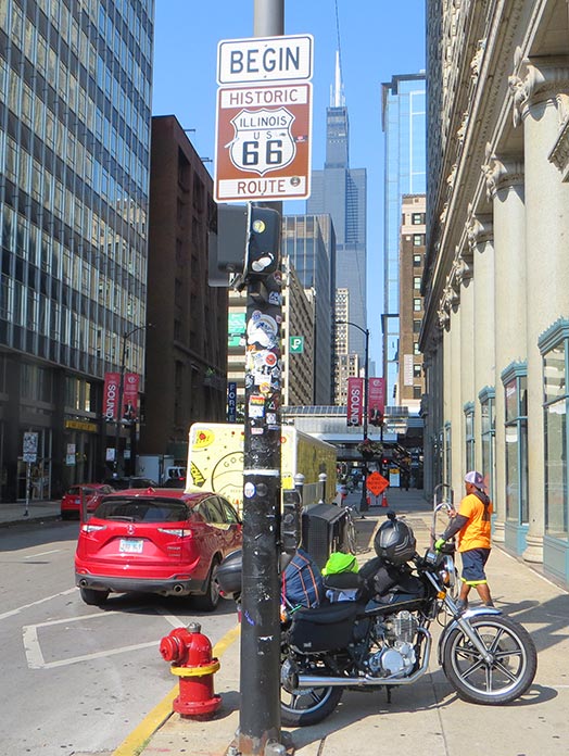
U.S. Route 66 begins in Chicago, Illinois, within sight of the Willis Tower (formerly the Sears Tower).
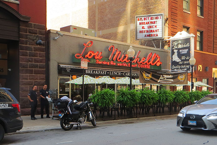
Since Route 66 starts in Chicago, I transported my bike from my hometown of Merritt Island, Florida, in my Chevy van. The first day of riding started in Chicago rush-hour traffic on the Kennedy Expressway, which was undergoing road construction, but after stop-and-go for two hours in record heat, I was rewarded with the U.S. 66 “Begin” sign at the corner of Adams Street and Michigan Avenue across from The Art Institute of Chicago. Just a few blocks away is the Willis Tower (formerly the Sears Tower), and a few blocks farther is the famous Lou Mitchell’s restaurant, which is over 100 years old and served a great breakfast to start my trip.
Lou Mitchell’s is a legendary eatery in downtown Chicago.
Aside from the sweltering temperatures and humidity of August, Chicago’s beautiful residential areas and parks made the short trip to the suburbs quite pleasant. The first 100 miles of Route 66 is known as the Heritage Corridor, which also includes towns along the Illinois & Michigan Canal, which connected Lake Michigan to the Illinois River, and Starved Rock State Park. In Cicero, I stopped to see one of Al Capone’s houses. In Berwyn, I checked out the world’s largest laundromat, which is over 13,000 square feet and even has a bird aviary, and I also passed by one of the oldest-operating White Castle restaurants.
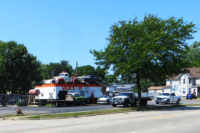
Dick’s on 66 is located in Joliet, Illinois.
Traveling south, I found a neat roadside display in the town of Joliet called Dick’s on 66, an old towing shop decorated with several vintage vehicles and a patch of bricks purportedly from the original Route 66. Across the street is a restored gas pump and ice-cream shop. Joliet is also the home of the state prison and was featured in the 1980 movie The Blues Brothers.
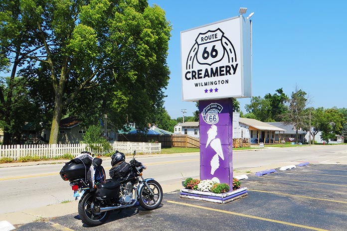
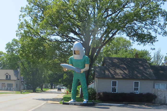
In Wilmington, Illinois, I cooled down with a sundae at the Route 66 Creamery and spotted the first of five “giants” I would see on my trip: a Sinclair dinosaur on the roof of G&D Tire Company.
Route 66 Creamery is in Wilmington, Illinois.
For this trip, I tried to take the oldest sections possible of Route 66, and Illinois had them clearly marked. Some sections of road looked more like abandoned driveways, with weeds growing through cracks in the concrete. My little SR500 was perfect for this kind of duty.
One of the few remaining Muffler Men is located in Wilmington, Illinois. The bright green Gemini Giant holds a silver rocket and was named in honor of the Gemini space program of the 1960s.
In Towanda is Dead Man’s Curve, a sharp curve that caught many drivers unaware and was the site of numerous accidents from the 1920s to the 1950s. There’s even a preserved series of Burma Shave signs that say: Around the curve / lickety-split / beautiful car / wasn’t it? I had a 25-plus mph headwind for most of that first day, and it felt as if I was riding into a blow drier. My first night was spent at the Ghost Hollow Lodge in Chandlerville, Illinois, where I fortified myself with a dinner of venison and fresh veggies.
On the second day, I stopped in Springfield to cool down with an iced tea at Route 66 Motorheads Bar & Grill, which also has a museum and gaming room. Just south of Springfield in Carlinville, my fun was interrupted by a flat tire. I had packed tools, tire irons, a portable compressor, and a tube patch kit, but my tube was too badly mangled by the nail. Scott McDaniels of S&S ATV came to the rescue by delivering a new tube (at no charge), a local resident across the street brought me ice water, and the local city hall allowed me to do the work on the north side of their office in the shade on the concrete. It just goes to show how kind strangers can be when you are in a bind.
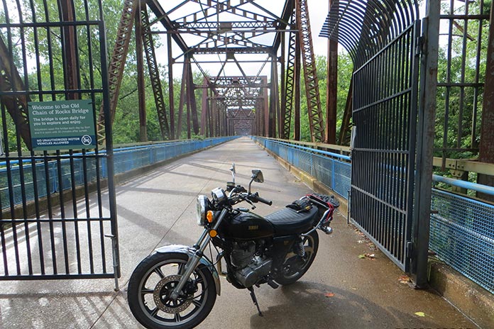
The Old Chain of Rocks Bridge is located in Granite City, Illinois.
The repair set me back almost four hours, and I had to bypass many of the Route 66 sights from Carlinville to St. Charles, Missouri, where I stayed with friends. The following day, I unloaded my luggage and backtracked to Granite City, Illinois, to see the Old Chain of Rocks Bridge. The mile-long bridge was part of the original Route 66 from 1936 to 1965 and allowed motor vehicles to cross the Mississippi River from Illinois to Missouri. It features a 30-degree turn partway through. I had gone over this bridge in a car as a kid before it was decommissioned in 1968. It is now only open to foot traffic and bicycles.
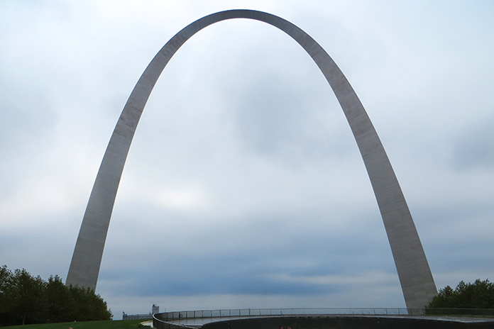
The 630-foot Gateway Arch in St. Louis, Missouri, was completed in 1965.
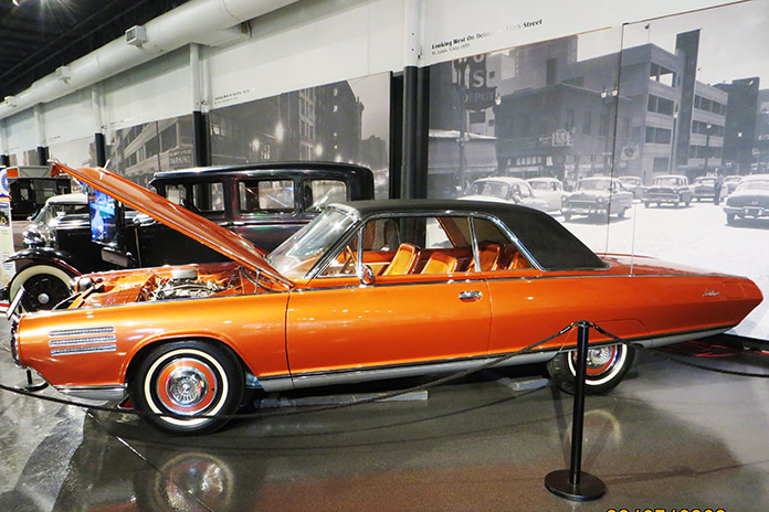
While in St. Louis, I also went up into the 630-foot Gateway Arch, which was completed in 1965. It is now part of the National Park Service, and with recent remodeling and upgrades, it’s a not-to-miss experience. I also visited the National Museum of Transportation on the west side of St. Louis. This may be one of the best transportation museums in the country and has the only remaining GM Aerotrains. It also has a running Chrysler Turbine Car like the one at the Henry Ford Museum in Michigan.
A Chrysler Turbine Car at the National Museum of Transportation in St. Louis.
After getting my luggage loaded back on the SR500, my next stop was Times Beach, Missouri. Route 66 used to cross the Meramec River there, and the remnants of the bridge are still there, along with a Route 66 State Park. I met some folks from Europe riding Route 66 on rented Harleys, and they were aghast that I was attempting to make the same trip on my antique bike with no GPS navigation and only an EZ66 guide in my tankbag.
Remnants of the Route 66 bridge in Times Beach, Missouri.
Times Beach was the site of the second largest EPA Superfund site due to a local contractor spraying dioxin on the dirt roads for dust control. All the buildings were bought by the EPA and leveled, and it’s currently considered a ghost town. West of Times Beach is the Meramec Caverns, where I ran into my new European friends again. My bike would do roughly 100 miles per tank of fuel, which coincided with my body’s need to stand up and stretch out a bit and suck down a cold beverage.
A group of Europeans riding Route 66 on rented Harleys stopped at the Route Route 66 State Park in Missouri.
I stayed at the KOA in Springfield, Missouri, that night and rented a cabin. I had planned on renting a primitive campsite, but for only about $40 more, I got an air-conditioned cabin, lights, electricity, a mattress, a table, and a TV. It was a bargain!
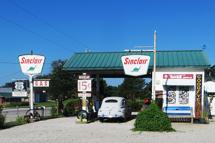
Along the way in Missouri are a few museums and stops such as a replica 1930s Sinclair station called Gary’s Gay Parita in Ash Grove, Missouri, where the sign reads “Gas Wars” and advertises fuel at 15 cents per gallon. Another sign reads “Kendal, your 2,000 mile oil!” We have certainly come a long way!
A replica 1930s Sinclair gas station called Gary’s Gay Parita in Ash Grove, Missouri.
Shortly after the Sinclair station on the Old Route 66 trail, I crossed an old truss bridge that crossed over Johnson Creek in Spencer, Missouri. Like the old sections of Route 66 in Illinois, this section looked like an abandoned road going into the backwoods. It was beautiful.
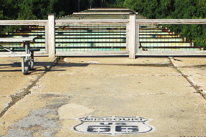
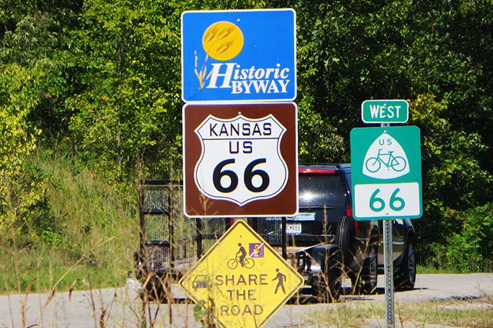
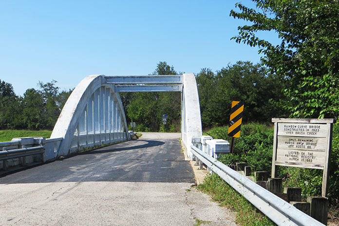
Only 13 miles of Route 66 pass through Kansas.
Kansas only has a very short 13-mile section of the Old Route 66 path, and if you take that, you are blessed with crossing one of the few remaining Marsh Arch bridges left in the country – and the only remaining one on Route 66, this one having been built in the early 1900s.
The Rainbow Curve Bridge was built in 1923. It’s the only remaining Marsh Arch bridge on Route 66.
Oklahoma likely has the most Route 66 sites of any state. After the road was decommissioned by the federal government for use as a federal highway, Oklahoma named it State Road 66. It’s easy to follow, although I did manage to miss a sign and ride maybe 50 miles off course. The best Route 66 Museum is in Clinton, Oklahoma. It covers the initial planning and construction of the route, along with different scenes of Americana, a video of the Dust Bowl, and more.
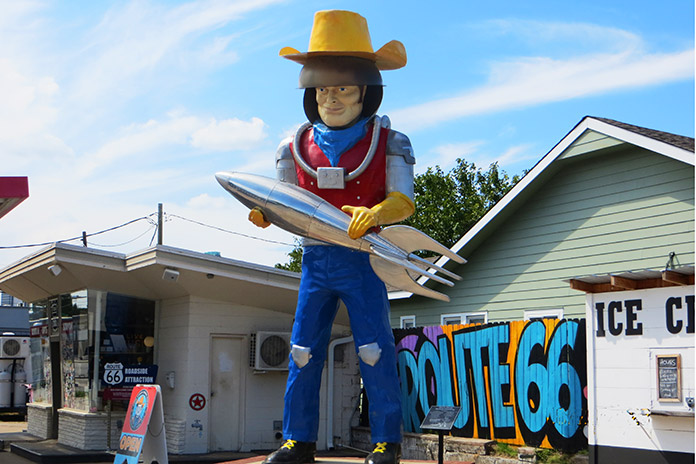
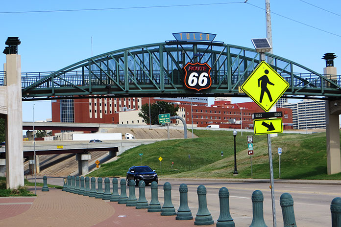
Buck Atom, a 21-foot-tall space cowboy in Tulsa, Oklahoma, is one of the iconic Muffler Men of Route 66.
There are more giant statues to be seen as you pass through Oklahoma, including Buck Atom, the 21-foot-tall space cowboy in Tulsa holding a rocket. Tulsa also has a cool park downtown called the Cyrus Avery Centennial Plaza that has three tall old neon motel signs relocated there from the early days of Route 66. Further south is a Route 66 village with an old train, a gas station, and an oil derrick.
Route 66 in Tulsa, Oklahoma.
The last section of Route 66 I rode in Oklahoma was a mostly abandoned concrete road that paralleled Interstate 40, but you could tell it was part of the original route. How many mostly abandoned four-lane concrete highways going into nowhere with no traffic do you see? At one point, I thought I was off-track, but then I saw the Texas state sign and the familiar white outlined Route 66 logo painted on the road.
In Texas, much of Route 66 is access highways on either side of the interstate, which worked just fine for my trusty mule since I could travel at more relaxed speeds in the intense heat. Along the way, you pass by the Leaning (water) Tower of Britten in Groom, Texas, and Amarillo gives you the Cadillac Ranch.
Cadillac Ranch is located in Amarillo, Texas.
After visiting the Cadillac Ranch, I stopped at a KOA, and when I tried to start my bike again, it didn’t fire up. It turned out to be an issue with the ignition system, and despite having the parts from my other SR500 shipped to me to attempt a repair, it didn’t take. I cut my trip short and loaded the bike in the back of a Penske truck and headed back east.
In spite of a flat tire, intense heat and humidity, and an ignition failure, this was the most fun I can recall in most of my life. In retrospect, I should have tried making this trip on a newer bike, but part of the fun was riding a kickstart antique.
If you are considering riding this road, I would suggest waiting until 2026 for the 100-year anniversary since I heard plans in various towns along the way for some centennial events, so it should be even better.
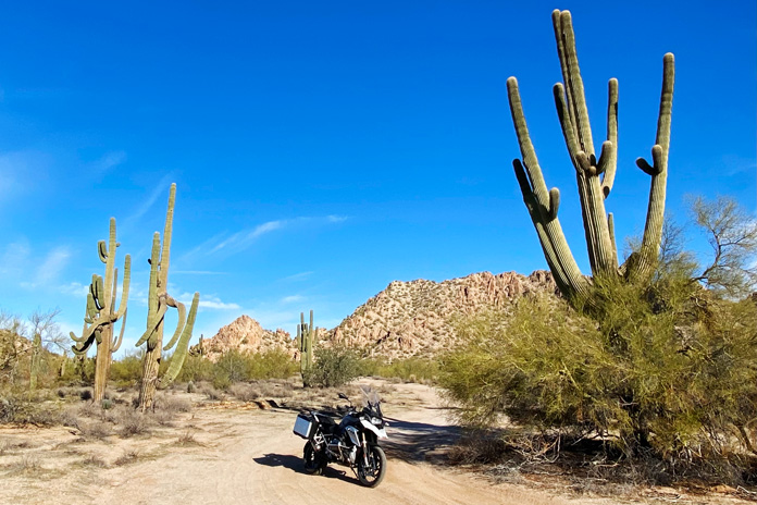
Nothing says “Arizona” like tall saguaros. These thorny towers are in the Sonoran Desert National Monument.
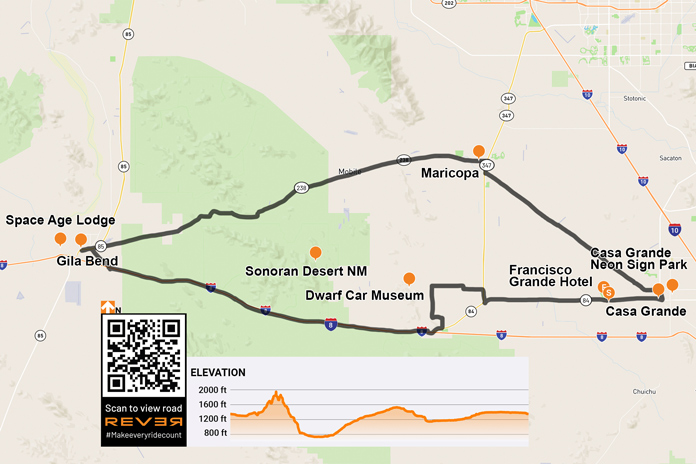
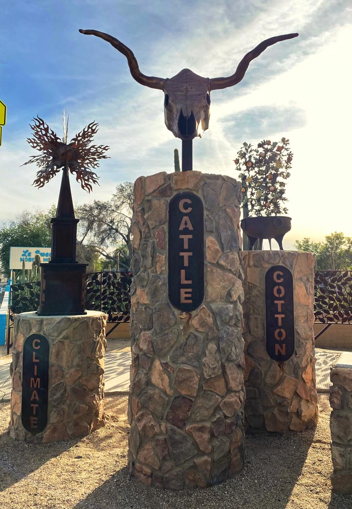
Arizona is known for its five Cs – copper, cattle, cotton, citrus, and climate – all of which are represented on the state’s great seal. I experienced three of them in abundance on this scenic southern Arizona loop, rolling past harvest-ready cotton fields and large dairy farms and enjoying spectacular weather. Two more Cs – cactus and cars – were also highlights of this entertaining ride.
Before you get the wrong impression from the title, I did not get locked up on this trip. “Big house” is the English translation of the Spanish “Casa Grande,” the starting and ending point of this loop ride. My trip began with a walk around the city’s downtown, which includes a tidy and interesting neon sign park, a nicely curated museum, a city park, and an impressive city square. Every January, the annual Historic Downtown Street Fair/Car and Bike Show draws upwards of 40,000 visitors to Casa Grande.
A roadside display in Casa Grande highlights some of the state’s foundational Cs.
After the stroll, I mounted my BMW R 1200 GS for the short ride to the Francisco Grande Hotel and Golf Resort. Tall palm trees stood sentinel as I rolled onto the resort’s beautiful property, which was established in the early 1960s as the spring training home of the San Francisco Giants. It was also a favorite haunt of John Wayne. After settling into my room and enjoying the incredible view, I had a delectable burger in the Duke’s Lounge and admired photos of Wayne, Willie Mays, Pat Boone, and other legendary visitors.
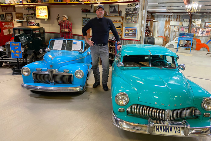
After a great night’s sleep, I mounted my GS and rode west through cotton fields and dairy farms to my first stop, the Dwarf Car Museum. The unassuming cluster of buildings belies the treasures displayed within. I paid my $5 entry fee and walked inside. At first glance, I could have been in any cool classic car museum, but as I got closer, the cars seemed to shrink.
The stunning and diminutive creations in the Dwarf Car Museum sit waist-high to the 6-foot-3 author. In addition to small cars, the museum also has an interesting collection of automotive memorabilia.
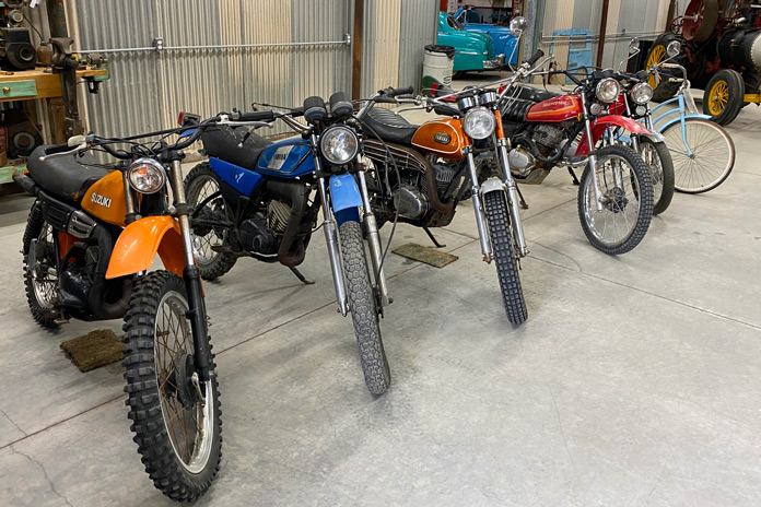
After scanning the whimsical, barn-like interior of the museum, I spotted a gentleman warming himself by a fire in the perfect man cave. Ernie Adams, the master builder of this eclectic and fascinating collection of diminutive classics, invited me to have a seat, and we had a nice chat about his life and his cars. Adams built his first dwarf car in the early ’60s, and they are about 11/16th scale. He bases every creation on a wheel size of 12 inches and miniaturizes everything else to that scale. Adams does not do much of the work anymore, but his son, daughter-in-law, and a friend carry on the tradition. He even has a tidy collection of vintage enduro bikes in a backroom.
What gearhead doesn’t have a soft spot for vintage Japanese dirtbikes?
Back on the GS, it was time to head to another C: the cactus-rich majesty of the Sonoran Desert National Monument, one of the most biologically diverse deserts in North America. Saguaros tower over the sand, each striking their own unique pose. With the rugged South Maricopa Mountains serving as the perfect backdrop, I explored a few established dirt roads off State Route 84.
On Interstate 8, I opened the throttle and made my westward ride through more of this desert grandeur. Interstates have never been my choice of roads, but this stretch of I-8 is as beautiful as they come. Various cactus varieties dot the rolling hills in the foreground, and distant mountain ranges create texture in the background.
The Casa Grande Neon Sign Park in the city’s downtown area preserves vintage neon signs from historic local establishments.
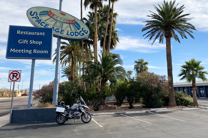
The ride west was relaxed and beautiful on the way to the final landmark on my list: the Space Age Lodge in Gila Bend. I have always been a fan of the rock band Rush, especially Neil Peart, who was arguably one of the greatest drummers in rock ‘n’ roll history. After tragically losing both his daughter and wife within a span of months, Peart rode his BMW GS more than 55,000 miles through North America, Mexico, and Belize, which he chronicled in his memoir, Ghost Rider: Travels on the Healing Road. One stop on Peart’s journey was the quirky, seemingly out-of-place Space Age Lodge, and I had to see it.
The music-loving author had to make a stop in Gila Bend to check out the Space Age Lodge, which was mentioned in Ghost Rider, Rush drummer Neil Peart’s amazing moto-centric memoir.
As I rolled out of town, one last incongruity caught my eye. Twin fighter jets crouched in front of a tiny airport on the outskirts of town. The pair of RF-101 Voodoos flew reconnaissance missions in Vietnam and now have a permanent home in Gila Bend.
It was time to head back to Casa Grande. Besides I-8, the other road that crosses the Sonoran Desert National Monument is State Route 238. This more northern road doesn’t have the towering saguaros of the interstate, but it is a relaxed desert ride with much less traffic.
The Museum of Casa Grande is housed in a beautiful Southwestern mission-style stone building. More than 40 buildings in the city are listed on historic registers.
This southern Arizona loop is best navigated from fall to early spring, as the desert temperatures are toasty in the summer. What it lacks in curves, it makes up for with a full plate of other entertaining Cs.
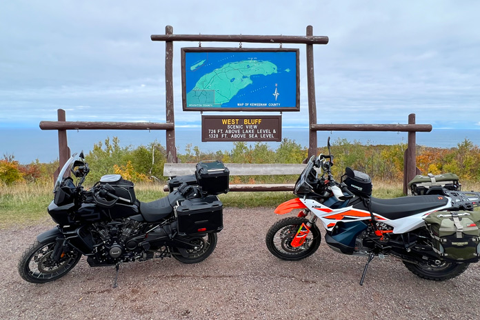
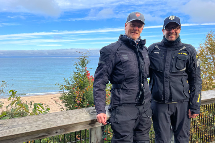
On the northern tip of Keweenaw Peninsula, West Bluff provides a sweeping view of Lake Superior and Copper Harbor, Michigan – a great spot to stop along this Michigan Upper Peninsula motorcycle ride. Photos by the author and Craig Moll.
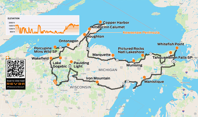
As a resident of Minnesota with incurable wanderlust, I’ve visited Michigan’s Upper Peninsula a few times, including doing the 1,300‑mile Lake Superior Circle Tour twice. But one area of the Upper Peninsula – known locally as the “U.P.” – I had yet to explore is the Keweenaw Peninsula, a 150‑mile‑long wedge of land that looks like a long dorsal fin jutting into Lake Superior. Before Old Man Winter brought an end to the riding season, my friend Craig and I squeezed in a mid‑October ride, making a big loop around the U.P. where we enjoyed the area’s rich history, unparalleled scenery, and excellent motorcycling roads.
We met up just east of Minneapolis in Hudson, Wisconsin, on a cool, clear autumn day. Craig was on his KTM 890 Adventure, and I was on my Harley‑Davidson Pan American, which I call “Dirt Glide.” With no rain in the forecast, we were excited to hit the road.
Lake Superior, which is the largest freshwater lake in the world by surface area and the third largest by volume, forms the northern shoreline of Michigan’s Upper Peninsula.
We crossed into Michigan on U.S. Route 2 and continued northeast on M‑28 to Lake Gogebic, the state’s largest inland lake. The long, finger‑shaped lake is a popular spot for outdoor activities year‑round. It has 13,380 acres of good fishing water, and there are plenty of opportunities for hiking, mountain biking, hunting, camping, and winter sports. Surrounded by vast hardwood forests, it’s a great place to see fall colors. It also gets an annual snowfall of nearly 300 inches and has an excellent snowmobile trail system.
Chuck and Craig at Sand Point on the Pictured Rocks National Lakeshore.
For motorcyclists, a loop around Lake Gogebic is an enjoyable scenic ride. M‑64 hugs the western shore, and East Shore Road hugs the other side, and there are parks, lodges, and dining options dotted along the nearly 40‑mile route. At the lake’s northern end at the junction of M‑28 and M‑64 is Bergland, which has places to eat, drink, and stay, as well as a museum highlighting the local history of mining, logging, and sports.
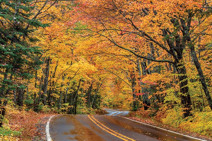
U.S. Route 41 runs the length of the Keneewaw Peninsula, from Baraga to Copper Harbor. In the fall, the changing leaves create a tunnel of color. Photo credit Danita Delimont / Adobe Stock.
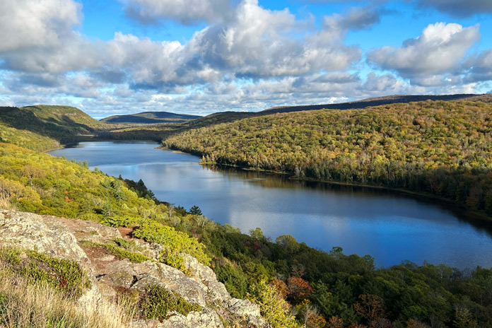
After enjoying the scenery of the lake, we continued up M‑64 to the Porcupine Mountains Wilderness State Park, Michigan’s largest state park and home of the Lake of the Clouds. Covering 60,000 acres with 35,000 acres of old‑growth forest, the park has waterfalls, rivers and streams, hiking trails, a campground, and miles of scenic Lake Superior shoreline.
Our ride up to the Lake of the Clouds scenic overlook was rewarded with a kaleidoscope of fall colors and scenery that lives up to the lake’s name. After a few photos, we were back on the bikes and followed M‑64 along the southern shore of Lake Superior to Ontonagon, where we turned inland on M‑38 to M‑26, which runs up the center of the Keweenaw Peninsula, also known as the Copper Country region.
Located in Porcupine Mountains Wilderness State Park along the shore of Lake Superior, Lake of the Clouds is idyllic.
At Houghton, we crossed the Portage Lake Lift Bridge and continued north on U.S. Route 41. With the sun fading, we rode to our overnight destination at the AmericInn in Calumet. The hotel is within walking distance of restaurants, stores, and the Keweenaw National Historic Park, which showcases the area’s 7,000‑year history of copper mining.
We wandered through Calumet, a small town that was in the heart of Michigan’s copper mining industry. Its historic downtown has gift shops, galleries, coffee houses, saloons, and restaurants. We made our way to the Michigan House Cafe & Red Jacket Brewing Co., which is in the former Hotel Michigan that was opened by Bosch Brewing in 1905. Today, it’s a restaurant and brewpub, and the Oatmeal Express stout was the perfect choice for a fall evening.
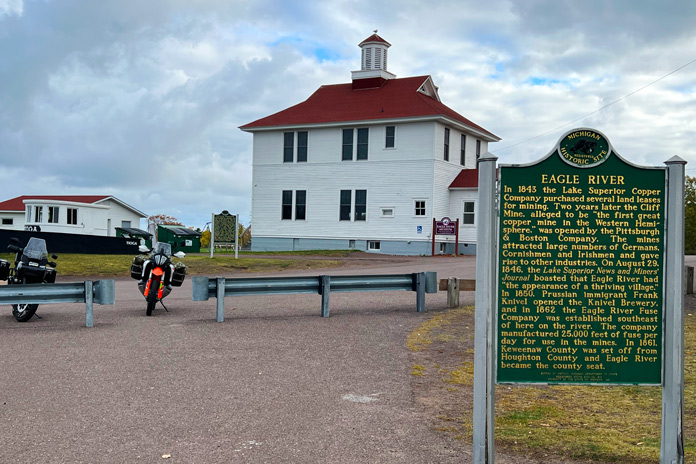
In the mid-1800s, Eagle River was a thriving mining town on the north shore of the Keneewaw Peninsula. We enjoyed a scenic shoreline ride on M-26 from there to Copper Harbor.
The next morning, we availed ourselves of the AmericInn’s complimentary breakfast and trudged out to our frost‑covered bikes. We continued riding on U.S. 41 in a northeasterly direction to Phoenix, where we turned due north on M‑26, which curves its way along the Lake Superior shore, offering amazing views and passing through nature and wildlife sanctuaries.
Before the town of Copper Harbor, we turned on to Brockway Mountain Drive, which gradually climbs up and over an eroded volcanic prominence that rises 720 feet above Lake Superior’s waterline. At West Bluff, we stopped to admire an unbelievable vista of the big lake to the north and the fall‑colored forest to the south.
Cinder Pond Marina is part of the charming waterfront in Marquette.
We cruised back downhill to Copper Harbor, Michigan’s northernmost town, which overlooks its namesake port near the outer tip of the Keweenaw Peninsula. Surrounded by Lake Superior, its microclimate is cool in the summer and relatively mild in the winter. Copper Harbor has a fascinating history, and the town is a great base camp for exploring the peninsula or a launching point for trips to Grand Isle National Park.
After gassing up, we headed south on U.S. 41 and then Gay Lac La Belle Road to the Bete Grise Wetlands Preserve and the southern shore of the Keweenaw Peninsula. We stopped for lunch in Houghton, which is located on the Keweenaw Waterway that cuts across the peninsula and was once at the epicenter of the region’s copper industry.
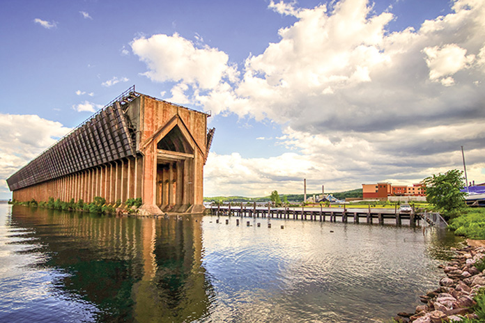
The massive concrete-and-steel Lower Harbor Ore Dock is one of the most iconic landmarks in Marquette. Photo credit ehrlif / Adobe Stock.
We rode south on U.S. 41, which runs along the western shore of Portage Lake and then Keweenaw Bay to L’Anse, where we returned to the mainland of the U.P. We followed U.S. 41 east to Marquette, a Lake Superior port city known for shipping iron ore from the Marquette Iron Range. With a population of 20,000 and home to Northern Michigan University, Marquette is the largest city on the U.P. We pulled into the Hampton Inn Marquette/Waterfront, which lives up to its name with an amazing view of sailboats and other vessels carving up the bay. Being a lively college town, Marquette has numerous bars and restaurants to choose from. We had dinner at the historic Vierling Restaurant & Marquette Harbor Brewery, named after Martin Vierling, who built the building in 1883 and ran a “gentlemen’s saloon” at the location until Prohibition. Renovated and reopened in the 1980s, the establishment has a historic wooden bar with large windows overlooking the harbor.
Firing up the bikes the next morning, we rode east on M‑28 to Munising and then on H‑58 for a few miles to Pictured Rocks National Lakeshore. We rode up to Sand Point, which has nice views across the water to Grand Island, a national recreation area.
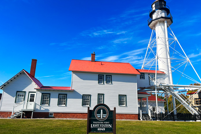
More ships have been lost in the vicinity of Whitefish Point, also known as the “Graveyard of the Great Lakes,” than anywhere else on Lake Superior.
The road to Munising and Sand Point was good, but the winding curves of H‑58 rivaled some of the best roads we’ve ever ridden, with extensive twists and turns carved through the forest and along the Lake Superior shore. We continued east to M‑123 to visit Tahquamenon Falls State Park, which covers 50,000 acres. The Upper Falls is one of the largest waterfalls east of the Mississippi River and is about 200 feet across and drops 50 feet. The Lower Falls are a series of smaller falls cascading in many directions.
East of the park, we made our way up to Whitefish Point, which is known as the “Graveyard of the Great Lakes” and home of the Great Lakes Shipwreck Museum. There have been 550 known shipwrecks in the area, and at least 200 of them are off Whitefish Point, including the famous SS Edmund Fitzgerald, which sank in 1975 and was memorialized in a popular song by Gordon Lightfoot.
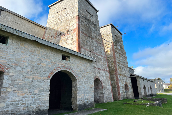
On the southern, Lake Michigan side of the Upper Peninsula, Fayette State Park is a restored 19th century iron-smelting village with 22 historic buildings, a museum, and a visitor center.
We made our way to the southern side of the U.P. on the northern shore of Lake Michigan, where we spent the night in Manistique, a recreational mecca for boating, fishing, camping, and snowmobiling. In the morning, we rode south on the Garden Peninsula to Fayette State Park, which overlooks Big Bay De Noc and was home to one of the U.P.’s most productive iron‑smelting operations during the 19th century. When the iron market declined, the Jackson Iron Company shuttered its operation in 1891.
Our return route west on U.S. 2 took us to Iron Mountain, home of the Pine Mountain Ski Jump and the annual Continental Cup, one of the world’s best ski jumping events.
Tahquamenon Falls State Park has 35-plus miles of trails and multiple viewpoints for the Upper and Lower falls.
Next we wanted to check out an interesting phenomenon called the Paulding Light, a mysterious light that appears at the end of a deadend road in a valley located between the towns of Pauling and Watersmeet off U.S. Route 45. The light has been reported since the 1960s, and various legends claim the light is the result of paranormal activity, the ghost of either a railroad brakeman who died in a train collision, a murdered mail courier, or a Native American dancing on powerlines.
Craig and I arrived at the location at dusk and waited for the light. At first we saw nothing, and then…wait…what’s that? Sure enough, a faint light appeared off in the distance above the tree line. Off and on it went, so we decided to pursue this mystery for ourselves. We rode down a steep, sandy, rock‑strewn powerline road to a narrow, rickety bridge that crossed a creek. As I hit the partially rotted bridge, I thought, Pan Am, don’t fail me now! Charging up the hill on the other side, we attempted to find the source of the light but to no avail. In 2010, students at Michigan Tech said they solved the mystery, claiming the Paulding Light is caused by headlights on a faraway highway. I like the ghost stories better.
One of our favorite parts of touring around Michigan’s Upper Peninsula was the many roadside waterfalls, creeks, and overlooks where we could stop and take a few quiet moments to appreciate nature’s beauty.
The next day, we returned home. It’s always bittersweet when a fun motorcycle trip comes to an end, but the great thing about exploring a new area is knowing we can always come back for more. Michigan’s Upper Peninsula offers seemingly endless opportunities for riding and recreation, with a rich vein of history that runs through the area like its deep deposits of copper and iron.
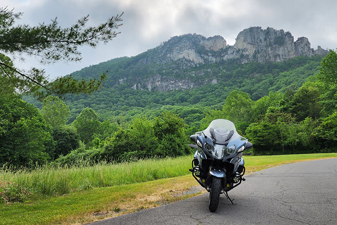
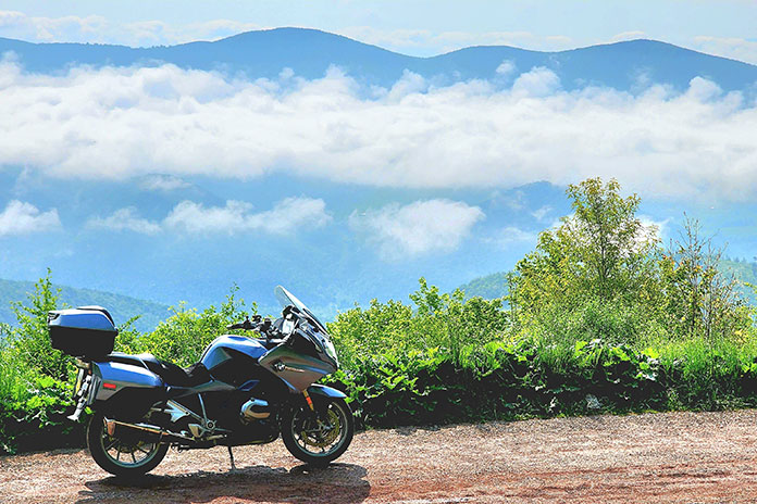
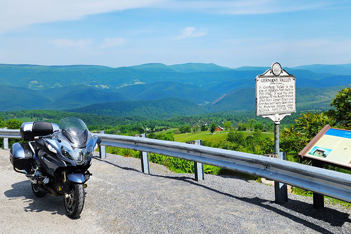
Fog was stubborn this morning at Seneca Rocks, but it couldn’t dampen my admiration for West Virginia backroads.
What I like most about motorcycles is that they lean, a trait I describe to nonriders as “dancing with a machine.” A motorcyclist can select a dance partner ranging from a svelte sportbike to a big‑boned tourer, but how well that partner performs depends on the quality of the dance floor: the road.
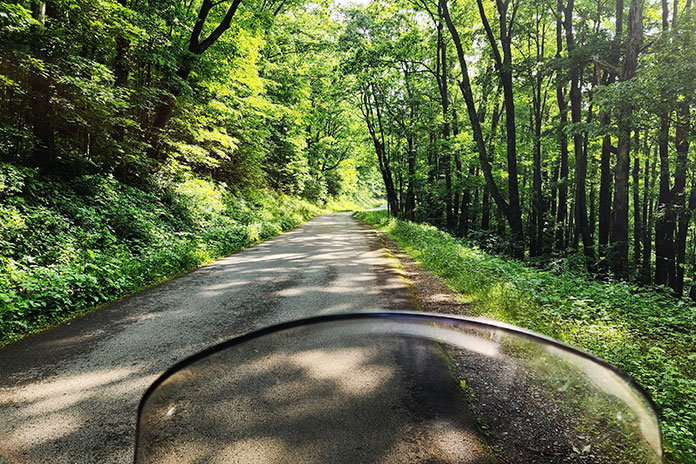
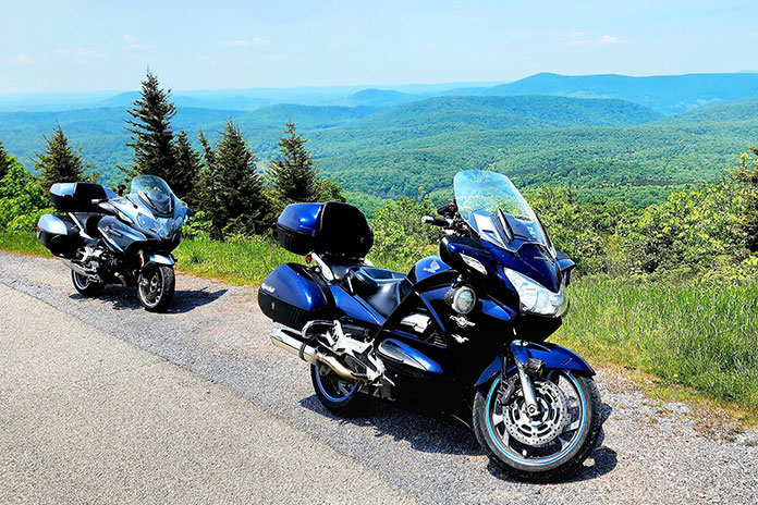
My favorite motorcycle dance floors are smooth asphalt ribbons that snake over mountains and along waterways, and some of the best I’ve found anywhere are West Virginia backroads. Appropriately called the Mountain State, it’s where the Allegheny, Blue Ridge, and Appalachian mountain ranges converge. With the highest average elevation of any state east of the Mississippi River, the roads curve over and around a rugged, varied landscape. The quality of road surfaces in West Virginia is generally superb (see sidebar at end of article). For riders who love to lean, it’s idyllic.
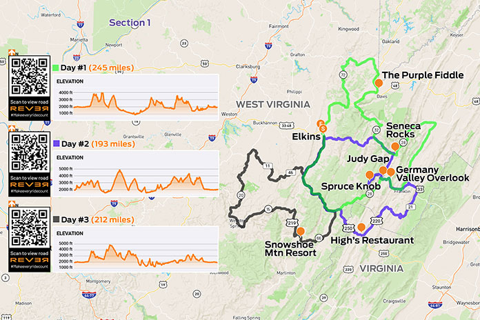
Scan QR codes above or click “Day 1,” “Day 2,” or “Day 3” to view routes on REVER
As I made my way south into West Virginia on these great winding roads, a familiar anthem played in my head, albeit somewhat revised: Asphalt heaven, West Virginia, Blue Ridge Mountains, Shanandoah River….
No disrespect to John Denver, but your humble scribe gives top billing to the West Virginia backroads. I was headed to Elkins, a small city at the edge of the Monongahela National Forest in the heart of Randolph County where a group of riders had bivouacked at the Holiday Inn Express. This location offered easy access to the region’s fantastic roads and a short walk downtown to multiple options for post‑ride dinner and libations.
Next morning, I mounted my BMW R 1200 RT and joined routemeister Ed Conde for a well-planned 245‑mile loop through the Allegheny Highlands. In morning fog, our group rode south on U.S. Route 250, then turned north on State Route 28 at Thornwood. The road was fantastically curvy, though a low‑pressure warning for my rear tire was a cause for concern. After turning east on U.S. 33 at Judy Gap, we stopped at the Germany Valley scenic overlook, which was fogged in but had room for several bikes to safely pull off the road. I discovered a screw in the center of my tread, but the right tools – and folks willing to help – made for a quick repair.
Stiff winds atop Spruce Knob forced these evergreens to grow leeward.
At Franklin, we turned north on U.S. 220. Just past Upper Tract, we continued north on Smoke Hole Road. This very narrow, winding two‑way road has continuous blind corners, elevation changes, and no center line, with several curves signposted at 5 mph. In one curvy section, we had to get past a farmer whose tractor was pulling a trailer with implements sticking out the side. He pulled as far over as he could, and we squeezed by and acknowledged his effort. The pavement was not as smooth as most roads that day, but the adrenaline meter was pegged. Smoke Hole Road isn’t for the faint of heart.
Located on U.S. 33 on the way to Franklin, this convenience store looked at home in West Virginia.
We rejoined SR‑28 near Cabins and wound our way south along the North Fork South Branch Potomac River to Seneca Rocks, where ragged rock ridges reach skyward 900 feet. During World War II, American soldiers trained on these cliffs, and many applied the skills they learned to scale the cliffs of Normandy on D‑Day. These days, the rocks are popular with climbers and photographers.
Our ride had been largely within the Monongahela National Forest, and we were back in the heart of it. We rode west on U.S. 33, north on SR‑32, north on SR‑72 (Dry Fork Road, another winding, single‑lane gem), and east on U.S. 48, part of the Seneca Trail, to the hip little town of Thomas in Tucker County. At The Purple Fiddle, where “Live Music Lives,” our lunch break included a performance by a physician-musician who sang about a strained relationship with his one‑eyed grandmother: “We don’t see eye‑to‑eye.”
David Somers of Northfield, New Jersey, motored toward the summit of Spruce Knob along NF 104.
Lunch cravings satisfied, we rode north through Silver Lake and Aurora, over to Macomber, and down to Parsons. A growing part of West Virginia’s energy industry is powered by wind, and we encountered giant turbines spinning atop ridgelines. Later, riding south on deliciously winding U.S. 219, a wide‑load pilot vehicle stopped all traffic so a tractor‑trailer hauling a giant windmill blade could get through a section of tight turns. The impressive rig rolled by as we waited. The long blade had wheel‑trucks attached directly to it, turning the blade into a trailer transporting itself. As the afternoon sunshine grew warmer, we eased back to Elkins.
Out of several local restaurants near the hotel, I picked C. J. Maggie’s and joined other riders for supper at the bar. Later, as we socialized on the hotel’s back patio, the mayor of Elkins, Jerry Marco, paid us a visit. Hizzoner was gracious and welcoming, genuinely pleased to have dozens of motorcyclists staying in his city.
Truth in advertising.
In the morning, I hit the road early and solo, with more twisties and high elevations being my key goals. As I pulled my bike up off the sidestand, I felt some soreness across my chest. Rowing the handlebars of a 630‑lb sport‑tourer at a quick pace over hundreds of miles of tight curves had proved a workout.
Aiming the RT east along winding U.S. 33, I made rapid progress toward Alpena, Harman, and Onego. Asphalt heaven, West Virginia repeated in my head as smooth, curvy blacktop unfolded like a roller coaster. It was worth the 600‑mile ride from my home in western Massachusetts to ride these roads. And here’s some down‑home irony: The primary author of John Denver’s hit “Take Me Home, Country Roads” is Bill Danoff, who revealed in an interview that the song was inspired by his upbringing…in western Massachusetts! Danoff felt the word “Massachusetts” didn’t sound musical, so he wrote the song about West Virginia.
A lay-by along NF 112 offered this midmorning vista toward Circleville.
I turned north on SR‑28 for a view of Seneca Rocks, then back south to U.S. 33 and Briery Gap Road, where a right turn revealed a view of wickedly serpentine asphalt ahead. Time to apply those trackday lessons on body position.
Farther on, a right onto National Forest 112 took me through a tunnel of trees. This road was fairly smooth, suitable for a spirited but reasonable pace. Sight distances were short, and at the crest of a blind rise, an oncoming car reminded me to be wary of oncoming traffic.
Zipping along NF 112 felt like being in a tunnel of trees.
A few switchbacks added excitement, but it was repeated deer sightings that quickened my pulse. A doe suddenly appeared in the road ahead, and I hit the binders. She trained her big ears on me and then looked behind. Moments later, a wobbly, spotted fawn appeared at her side. It was captivating to see two beautiful road hazards step effortlessly up a steep incline and vanish into the woods.
Turning right onto NF 104 took me to the summit of Spruce Knob. At 4,863 feet, it’s the highest ridge in the Allegheny Mountains and the highest point in West Virginia. On this clear day, the view from Spruce Knob was spectacular.
Spectacular view from Spruce Knob, the highest point in West Virginia.
Reversing course, I again savored those wicked twisties descending Briery Gap Road. My ears popped as I reached U.S. 33, now 3,000 feet below the summit. I stopped again at Germany Valley, this time enjoying a fog‑free view and no flat tire, then rode all the way to Brandywine in Pendleton County. I turned south on County Road 21 and rode past Sugar Grove Station, a National Security Agency communications site that reportedly intercepts all international communications entering the eastern U.S. Since I wasn’t expecting any illicit communiques that morning, I turned west to enjoy curvy Moyers Gap Road.
With no fog and no flat tire, the view of Germany Valley was beautiful.
At U.S. 220, I turned south and briefly entered Virginia (what a young boy there called “regular Virginia”). At U.S. 250, I cut right and stopped in Monterey for a late lunch at High’s Restaurant. This venerable eatery now holds the distinction of serving me the best fish sandwich I’ve ever had: rainbow trout, sourced from a local creek, fileted and grilled to perfection, and piled on a brioche bun. “Delicious” can’t do it justice.
High’s Restaurant in Monterey, Virginia, is a great spot for lunch.
As I continued north and east on U.S. 250, I rode up and down ridges and leaning through a succession of tight curves that had me laughing inside my helmet. And it was clear the instant I crossed the state border and entered Pocahontas County: Virginia’s road surfaces are good, but West Virginia’s are superb.
From Thornwood, the ride back to Elkins reversed the beginning of the previous day’s route. A fun road in the opposite direction was its own fun ride. Back at the hotel, I connected with other riders and walked downtown to another local eatery, Mama Mia Pie & Pasta. Over Italian entrees and local craft beers, we compared notes from our day’s riding.
David Somers (foreground) and Mitch Pivor of Dover, New Hampshire, motored down from the summit of Spruce Knob along NF 104.
Morning presented another opportunity to ride glorious West Virginia asphalt, this time with my long‑time riding partner Steve Efthyvoulou. Temps started cool, and the previous day’s crystal blue sky was now tarnished gray with smoke from massive wildfires in Canada. We went south on U.S. 250, a now‑familiar route out of Elkins. Turning south on SR‑28, we saw signs for the Green Bank Observatory, home of the world’s largest steerable radio telescope. Astronomy nerds will want to stop, but today we were observing asphalt, laid out before us in smooth, banked curves.
The view over Hightown, Virginia, from a lay-by along U.S. 250. Steve and I rode through that farm a few minutes later.
At SR‑66 we turned west toward Snowshoe, one of West Virginia’s premier ski resorts. It was June, so the slopes were green, and we stopped for lunch at Kickin’ Chicken. Loaded with protein, we paralleled the Tygart Valley River on U.S. 219 north to Valley Head, where a left onto SR‑15 set us up for an afternoon twist fest. The road presented often tricky curves to Webster Springs, where we picked up SR‑20 for more fantastic curves. Flat light due to the wildfire haze softened the contrast between sun and shadow, improving visibility on these technically challenging roads.
Some roads just sound enticing. This one is off U.S. 33 near Oak Flat.
Near the West Virginia State Wildlife Center, we turned right onto Alexander Road. This narrow, curvy two‑lane is full of tight corners and elevation changes, all the way to U.S. 250, where we turned north on a familiar route back to Elkins. Another amazing day was in the books. Though I had previously ridden through West Virginia several times on the way to other riding destinations, this was my first dedicated trip to ride the Mountain State – and I just scratched the surface. Without a doubt, there’s asphalt heaven on West Virginia backroads.
Randy Damron, a liaison between West Virginia’s departments of Transportation and Tourism, clued me in. Damron rides a Honda Gold Wing and a Kawasaki KLR, so he understands the motorcycling community. He explained that the improved quality of the state’s roads in recent years owes much to “Roads to Prosperity,” a road construction and maintenance initiative to support West Virginia residents, industry, and tourism.
Transportation and Tourism partnered to create four West Virginia Mountain Rides (with more on the way) that are in excellent condition, have good shoulders and guardrails, and run through beautiful scenery. The Seneca Skyway, for example, is a signposted 300-mile loop that includes several roads covered in this story. Go to the West Virginia Department of Tourism website and click on “Road Trips” to learn more.
There are several hairpins just west of the 1.1‑mile Zion‑Mt. Carmel Tunnel, which separates distinctly different parts of Zion National Park in southern Utah.
Living at 6,000 feet in Cedar City, Utah, most of my winter riding involves heading south, which offers a quick drop in elevation and less chance of the falling white stuff. So that’s what I did a week before Christmas, giving myself a gift of a one‑day ride through some southern Utah and Arizona history.
The day promised unseasonably warm temperatures…eventually. Just after the sun peeked over the mountains, the ambient temperature was in the upper 20s, but doing 80 mph on the interstate meant I was closer to single digits. Thankfully, the BMW R 1600 GTL Grand America I was riding offers great wind protection, and with my California Heat heated apparel (see California Heat gear review here), I didn’t need to use the bike’s seat or grip warmers.
Utah is one of the few states where even interstate riding offers great views. Descending the Black Ridge south of Cedar City, the mountain terrain changes from gray and sage green and reveals distant red rock mesas. Exiting Interstate 15, I took State Route 17 to Hurricane and connected with State Route 59.
After a quick climb out of Hurricane, SR‑59 flattens out and heads south. Just a few miles outside of town, jagged peaks painted in rust, deeper reds, and oranges rise in the distance. Much of this area is managed by the Bureau of Land Management, and numerous dirt roads meander from the highway.
If you keep your eyes open on the east side of Zion National Park, you’re likely to see a mountain goat…and much less tourist traffic. Plus, the curvy road is open to motorcycles all year.
Within an hour, the temperature had risen nearly 20 degrees as I rolled into the small twin cities of Hildale, Utah, and Colorado City, Arizona, an area locally known as Short Creek. Much has already been written about this area that is both the last U.S. stronghold of the FLDS church (read: polygamists) and the non‑FLDS members struggling against that stigma, so I’ll just say they have a beautiful place to live.
Continuing on, the road isn’t especially exciting, but the scenery remains impressive. Crossing into the Kaibab Indian Reservation, the road heads east, paralleling red cliffs to the north. To the south, on a clear day, you can see as far as 60 miles into the Arizona Strip – a wedge of that state between the north side of the Grand Canyon and the Utah border – without any signs of humanity. The desolation makes it easy to imagine life a couple centuries ago. However, not far onto the reservation is a sign for Pipe Spring National Monument, an oasis in the desert where Mormon pioneers erected a fort in 1872 for protection against some of the very people whose land they had settled on. Located a half mile off the highway, the museum and fort are worth a visit.
The fort at Pipe Spring National Monument was built as both a ranch house and protection for settlers during the Black Hawk War. It later served as a refuge for polygamist wives.
Farther east, I picked up U.S. Route 89 in Fredonia, and 7 miles later, I rode into Kanab, Utah, known as “Little Hollywood” for its filmmaking history, particularly old Westerns. My family likes to come here in February for the annual Balloons & Tunes Roundup hot air balloon festival. The historic Parry Lodge is a fun place to stay, and there’s a good mix of dining options.
Outside of town, the road cuts into the red rock, climbing and then dropping again into Mt. Carmel Junction, with the landscape colors changing from red to white to yellow.
The only thing missing from this photo taken in Kanab, Utah, (aka “Little Hollywood”) is a locomotive.
Taking State Route 9, this diversity of landscape continues with almost every twist and turn, both in tones and textures, leading to the east entrance of Zion National Park. For most of the year, you can only get up the road into Zion’s main canyon via shuttle, but as spectacular as the towering cliffs in the main canyon are, I much prefer riding on the east side, which is always open. It’s like an alien landscape, and with the slower speeds, you get to enjoy both the views and the numerous curves.
The Zion Canyon Scenic Drive is closed to personal vehicles most of the year.
On the west side of Zion is Springdale, a typical national park gateway community with lots of lodging and dining options (depending on the season), as well as art galleries and novelty shops. Just a few miles past Springdale is Rockville, where you can detour on Bridge Road to cross over the Virgin River on the last surviving Parker‑through‑truss bridge in Utah. Continuing 3.5 miles on this road, which turns to dirt about halfway, takes you to Grafton Ghost Town, where parts of Butch Cassidy and the Sundance Kid were filmed.
The Rockville Bridge is listed on the National Register of Historic Places. Built in 1924, it enabled the first direct link from the Grand Canyon North Rim to Zion National Park.
Staying on SR‑9, it’s about 16 miles from Rockville to close the loop at SR‑17 in La Verkin, where I made my way north and back home. Like the places I’ve ridden through, this Favorite Ride is now in the history books.