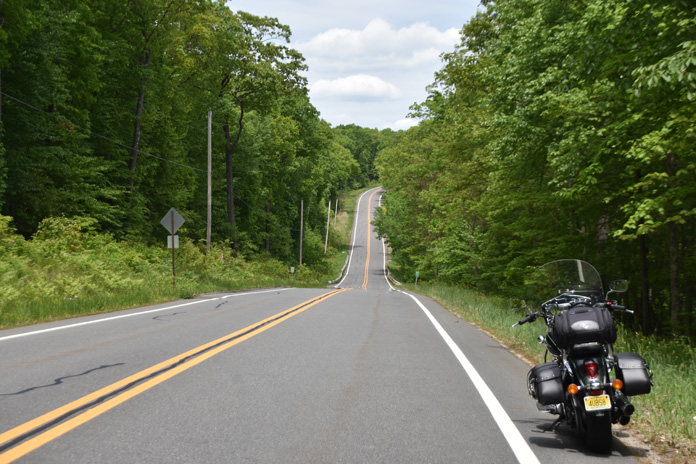
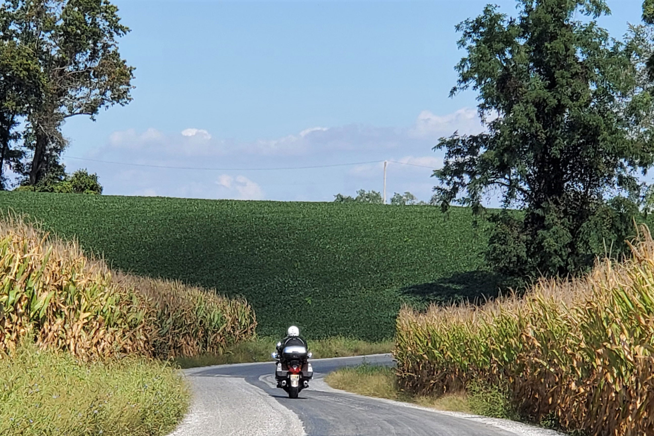
The empty expanses of the rolling, twisty New Jersey County Route 650 beckons riders from the tri-state area and beyond. (Photos by the author)
Greenery, blue skies, and sunshine were bursting forth upon the land like an invitation from Mother Nature to fire up my machine and go forth on a ride on some of my favorite northeastern backroads. I accepted her call and began my cruise a few miles north of the New Jersey border in Pine Island, New York.
Negative depictions of the state in film and television cause some people to think New Jersey is covered in urban sprawl, oil refineries, and clogged “highways jammed with broken heroes on a last chance power drive,” as Bruce Springsteen put it.
Although true for some parts of New Jersey close to the metropolises of New York City and Philadelphia, it’s called the Garden State for a reason. Northwestern New Jersey and northeastern Pennsylvania are blessed with farmland, forests, lakes, rivers, state parks, small towns, country churches, and most importantly, great roads to ride. Those blessings make this loop route a memorable favorite ride.
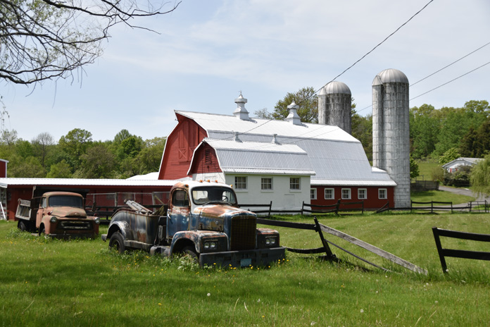
If you had to guess, would you think this scene was in New Jersey? With farms, forests, and few people, it lives up to the Garden State name.
With the sun warming my face and the sweet fragrance of greenery filling my lungs, I rumbled south on my Kawasaki Vulcan 900 Classic LT. I had sold my heavy Vulcan 1700 Voyager, and although I missed all its bells and whistles, I enjoyed the backroad nimbleness of the much lighter 900.
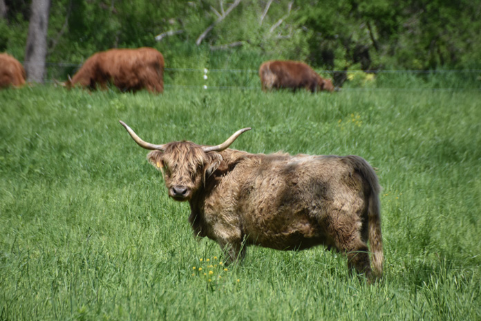
On Glenwood Road (County Road 26) just north of the New Jersey border, the Blue Arrow Farm has an impressive replica of a western Plains Indian village. In New Jersey, Glenwood Road splits, and I turned west onto the rolling, serpentine County Road 565 and stopped at the unique Farm at Glenwood Mountain. Encompassing 170 acres, it sells grass-fed, free-range beef from Scottish Highland cattle, free-range chicken, eggs, turkey, and pork, as well as local honey and organic fruits and vegetables. They also host private farm-to-table dinners and weddings.
A “wooly bully” at the Farm at Glenwood Mountain stares down the author.
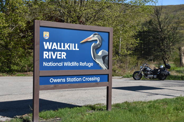
Rolling southwest toward Sussex takes you along the border of Wallkill River National Wildlife Refuge, which runs 9 miles along the Wallkill River (one of the few rivers in the U.S. that flows north) and protects 5,100 acres of land. Wildlife abounds in this area, including waterfowl, raptors, coyotes, deer, and bears. Throughout my years cruising through rural New Jersey, I have been lucky enough to spot several bears, as well as red foxes, a coyote, and numerous great blue herons.
Wallkill National Wildlife Refuge is an ideal place for quiet nature walks.
After crossing over State Route 23, I passed The Village Smith and Cycle Works, a motorcycle repair and blacksmith shop where you can get new tires for your motorcycle and new shoes for your horse. Naturalist writer and gadfly Henry David Thoreau said to “simplify, simplify” your life. In rural New Jersey, we say “diversify, diversify” your life to succeed.
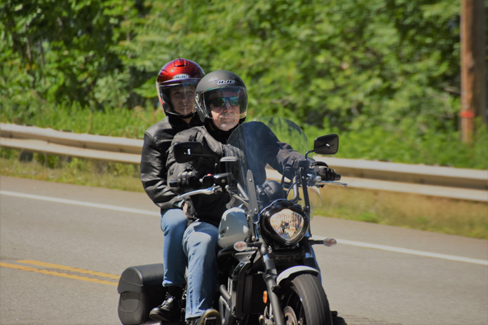
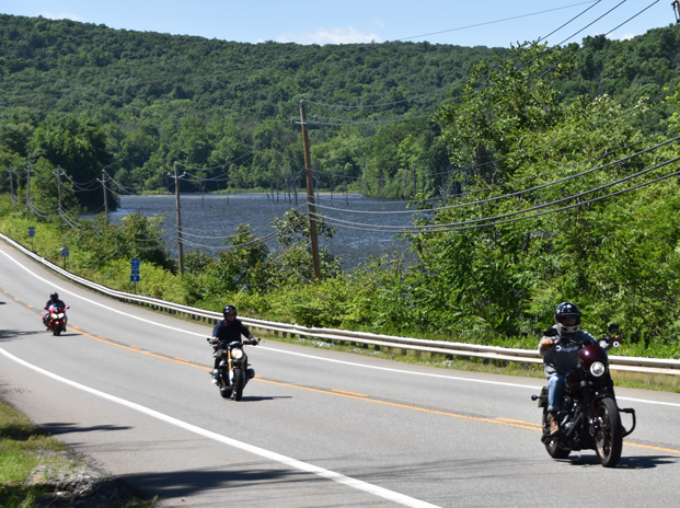
A rider and passenger cruising one of New Jersey’s empty country roads on a spring day.
Continuing on 565 to rustic Plains Road, I connected with U.S. Route 206. Cruising north toward Kittatinny Mountain, I saw some interestingly named eateries, such as Jumboland Diner and Firehouse Bagels, which has a real firetruck as part of its decor.
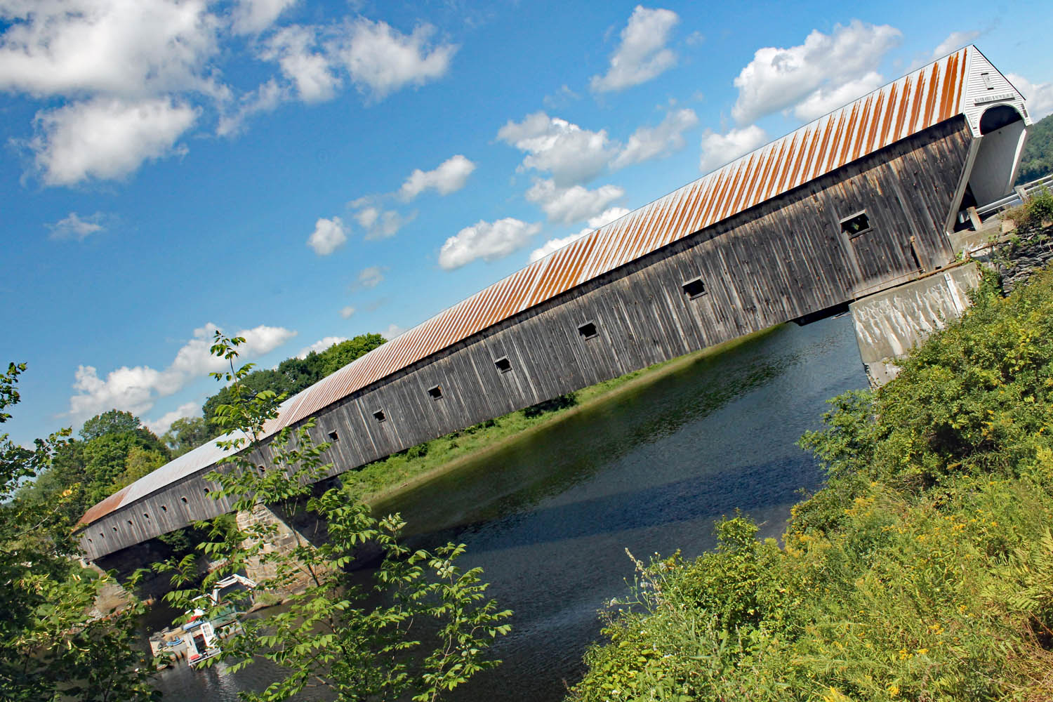
Passing through part of Stokes State Forest, which encompasses more than 16,000 acres, I turned onto County Route 560, sailing toward the Dingmans Ferry Bridge, one of the few remaining privately owned bridges in the United States.
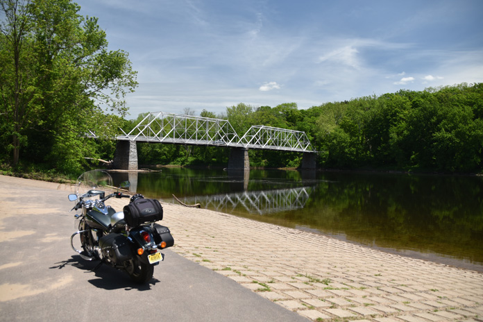
The author’s Vulcan 900 soaks up some rays in Pennsylvania next to the pristine water of the Delaware River and the Dingmans Ferry Bridge.
Opened in 1900, the bridge is 530 feet long and crosses the Delaware River into Pennsylvania. Riding high above the river on a motorcycle over its wooden planks is quite the experience. This rustic bridge lies within the Delaware Water Gap National Recreation Area, which spans 70,000 acres in Pennsylvania and New Jersey. A boat-launching area next to the crossing has views of the bridge.
Two impressive waterfall areas are nearby: Dingmans Falls and Childs Park. Both are worth a stop. Dingmans Falls is reached by a short, flat stroll on a boardwalk through the forest and alongside the stream. Childs Park is more challenging, with stairs going both up and down and a rugged walkway.
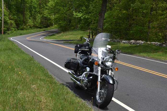
The author’s Vulcan rests proudly on one of the many curving roads that grace this rural ramble through New Jersey and Pennsylvania.
After a brief respite by the river, I fired up my machine and took State Route 739 to Silver Lake Road – a winding, rolling traverse through state forest land, lakes, and hidden gated communities. With areas of huge trees and forests lining the road, you get the feeling of motorcycling through primeval times. Route 402 north is much the same but is a faster-paced ride.
Blooming Grove Road (County Road 4004) and Well Road (CR 434), meander past country stores, rural homes, and forests. I felt like I was riding through a simpler era in America. At U.S. Route 6, a scenic byway that traverses the northern part of Pennsylvania, I roared toward Milford, a touristy town with several good restaurants.
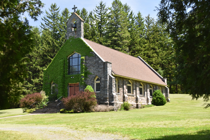
The stone edifice of the St. John Neumann/Good Shepherd Parish stands stoically in the aptly named Lords Valley, Pennsylvania.
After a late lunch at the Apple Valley Restaurant, I cruised across the modern Milford-Montague Toll Bridge with great views of the river back to Jersey. County Route 650 serpentines back through Stokes State Forest, which is a favorite of riders who love to challenge its rolling curves or just cruise along serenely. Traveling Routes 519 and 23 to Sussex, I headed northeast on State Route 284 to Bassetts Bridge Road, Lake Wallkill Road, and Glenwood Mountain Road.
Riders returning from the Pennsylvania/New Jersey hinterlands while appreciating the roadside scenery.
As my Vulcan weaved through the countryside to Routes 565/517 and back to Pine Island, I reflected on what an enjoyable ride it had been. It was one I was destined to repeat.
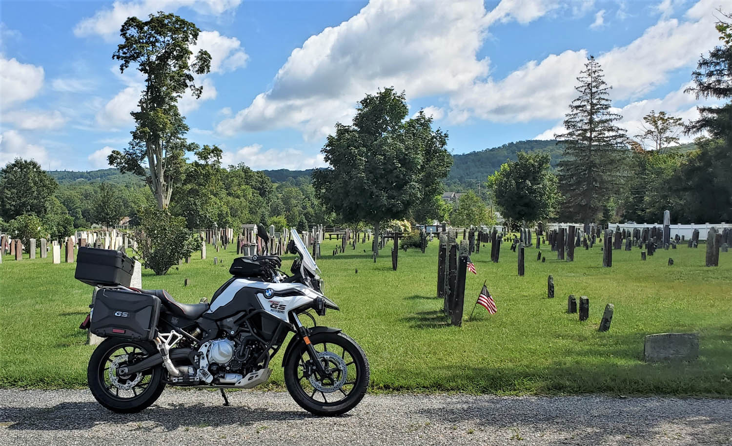
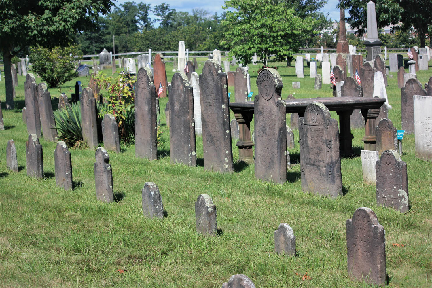
In early New England graveyards, such as Adams Cemetery in Wilbraham, Massachusetts, grave markers are irreplaceable historical documents that tell stories carved in stone. (Photos by the author)
“You’re riding your motorcycle to find graveyards – on purpose?” The conversation with a young police officer on a road construction detail in western Massachusetts was brief, but it motivated me to share why old graveyards are fascinating places to explore.
Rewind to the 1970s. My dad was a college professor whose academic interests included early New England graveyards. On weekends and summer vacations, he dragged my sisters and me along to find them. Long before GPS, such trips often became a quest since Dad’s approach to navigating involved dead reckoning. “I wonder where that road goes?” he’d say. “One way to find out.” It’s fair to say that Dad informed my interest in exploring on motorcycles.
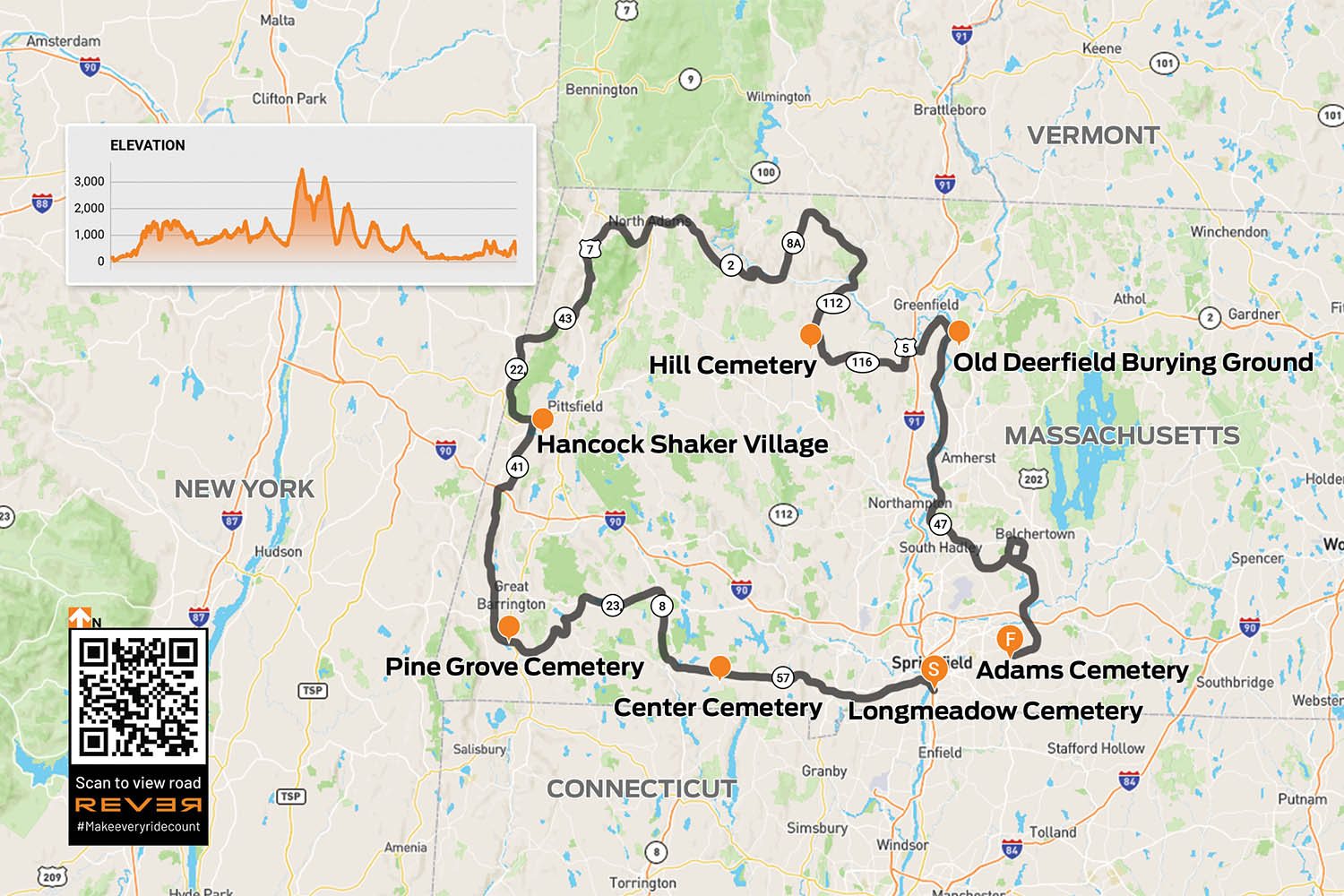
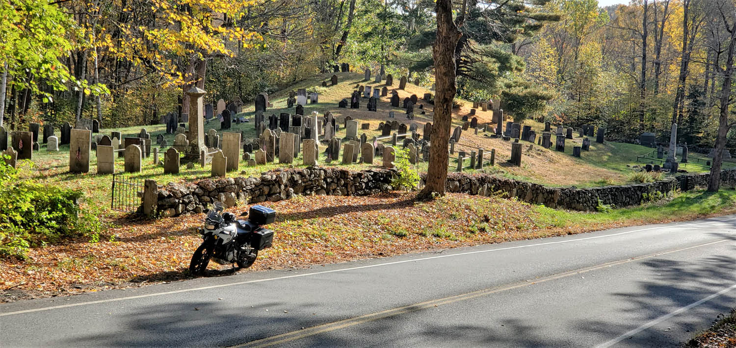
Since Massachusetts has some of America’s oldest communities settled by Europeans, it has some of the country’s oldest graveyards. Three of Dad’s favorites were in the towns of Longmeadow, Deerfield, and Wilbraham, all in the Connecticut River Valley of western Mass. I decide to revisit these graveyards with the benefit of an adult perspective. Since they’re not even 40 miles apart, I extend the ride a couple hundred miles using Dad’s “I wonder where that road goes” approach, and along the way I find other old graveyards to explore.
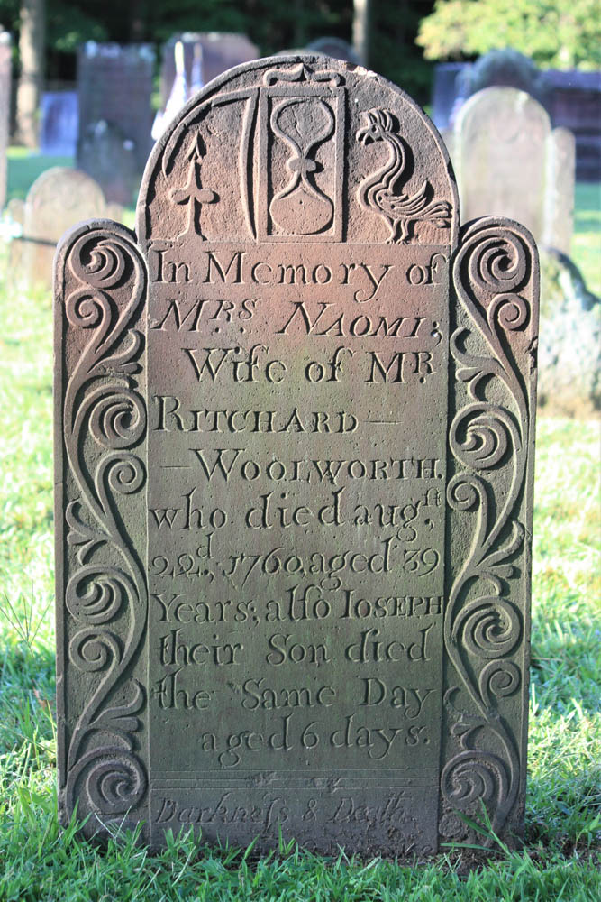
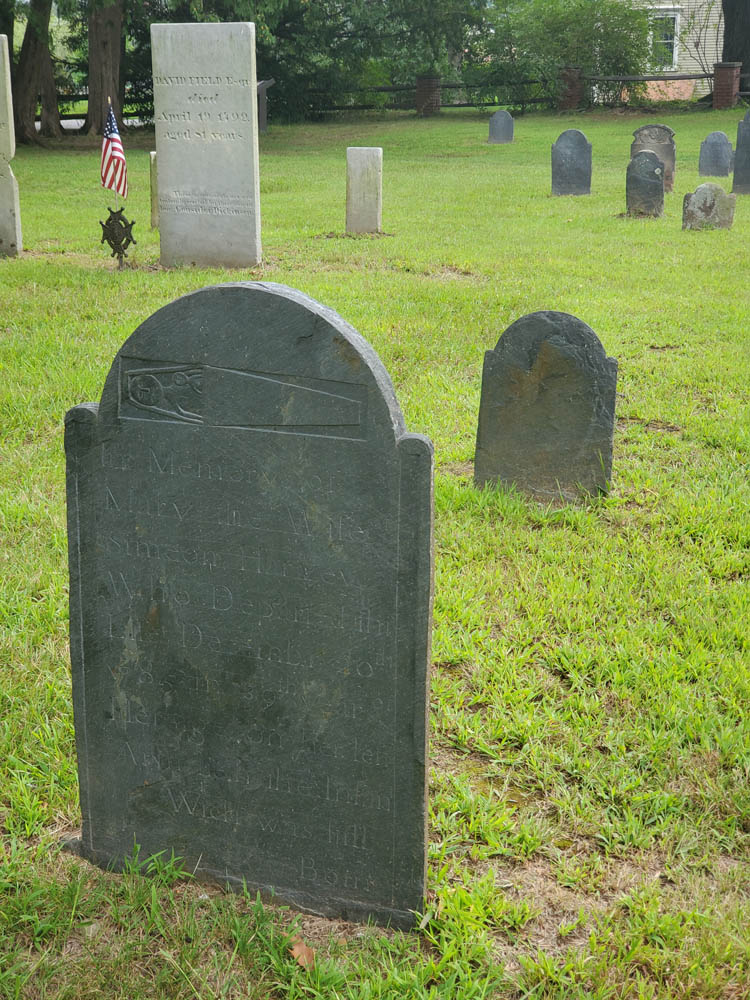
A cut flower signifies death, an hourglass shows time has run out, but a rooster suggests a new dawn.
With eyes looking up and wings, this effigy implies the soul’s flight to heaven.
The ride begins in Longmeadow. Along Williams Street, behind historic First Church, is the Olde Burying Ground, c. 1718, a small section within Longmeadow Cemetery. In old graveyards like this, carvings in stone offer insights into family life, social status, occupations, religious beliefs, sickness, tragedy, and the ways people conceived of death.
The Olde Burying Ground, c. 1718, a section of Longmeadow Cemetery, is the town’s oldest burial ground.
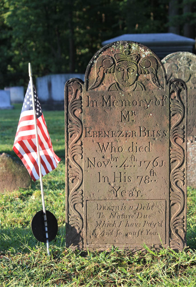
The stone of Ebenezer Bliss concludes with this stark epitaph: “Death is a Debt To Nature Due Which I have Pay’d And so must You.” The nature of one’s death is often explained, such as from smallpox, childbirth, or drowning, although Adjt. Jonathan Burt’s stone leaves us wondering, because he “departed this life in a sudden and surprising manner.”
From Longmeadow, I point my BMW F 750 GS north on U.S. Route 5 across the Connecticut River, then west on State Route 57. To avoid built-up sections of Agawam, I cut through Rising Corner and rejoin 57 past the Southwick fire station. The curves beyond Granville Gorge entice me to quicken the pace, though as I enter the village of Granville a flashing speed limit sign convinces me to roll off.
Center Cemetery, c. 1753, in Granville was located away from the church, a widespread practice at the time.
Up the hill beyond the town hall, I come upon Center Cemetery, c. 1753. As with many old graveyards that are no longer “active” (accepting new burials), one cannot drive into this graveyard, so I park just off the road. Also like many old graveyards, it isn’t next to a church. Some early settlers of New England, notably Puritans, located their dead away from the everyday lives of the living.
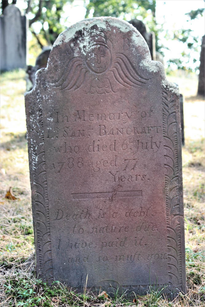
The headstone of Lt. Samuel Bancraft, Granville’s first settler, includes a slight variation of the epitaph I saw earlier in Longmeadow: “Death is a debt, to nature due. I have paid it, and so must you.”
This headstone in Center Cemetery includes a variation of an epitaph popular in the era.
“…on her left Arm lieth the infant Wich was still Born.”
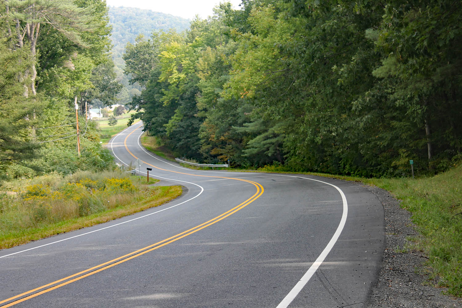
Continuing west, I enjoy several miles of new tar, but on the steep downhill curves to New Boston I am cursing the inventor of tar snakes. Beyond the village, I notice unpaved Beech Plain Road, and a right turn takes me along stands of trees dressed in vibrant yellow fall foliage. There’s not a tar snake in sight.
In Otis, I merge onto State Route 8 north and then lean west onto State Route 23, an entertaining two-lane that hugs the contours of the Berkshire Hills. Past the village of Monterey, I see a sign for River Road. Dad explained that roads of that name are usually curvy and rarely dead end. Right on both counts!
Any dog-loving rider needs to find out where this road goes!
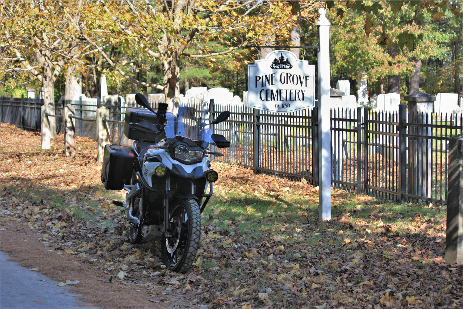
Following a bridge-out detour, I arrive in Sheffield. On the other side of U.S. Route 7 there’s a sign for Bow Wow Road, and being a dog lover, I need to see where it goes. A ways after it turns to dirt, I find Pine Grove Cemetery, c. 1758. I see family plots for Olds and Curtiss and wonder if these graves include ancestors of the automobile and aviation pioneers of those names.
I continue on North Undermountain Road and Pumpkin Hollow Road. At the village of Alford, Center Cemetery, c. 1780, warrants investigation. Among the finds is this pithy epitaph: “Gone not lost.”
Down the road a piece, Bow Wow Road turns to dirt and delivers your humble scribe to Pine Grove Cemetery in Sheffield.
Leaving the town center, West Road gets the nod over East Road, and after a couple turns I’m on State Route 41 riding north through Richmond to Hancock. History buffs can visit Hancock Shaker Village. Shakers were a religious community known for their elegantly functional barns and furniture, and for their devotion to celibacy. (The latter may account for their current lack of numbers.)
Heading west on U.S. Route 20 takes me over the New York border to State Route 22 north and Stephentown. A right on State Route 43 returns me to Massachusetts, having sidestepped Pittsfield’s population center. Another right on Brodie Mountain Road leads to U.S. 7 north. At the five-corners intersection, I turn right onto State Route 43 and follow the Green River to Williamstown, a quintessential New England college town. At the junction of State Route 2, a left leads to lively Spring Street and multiple options for eats and coffee.
In the 18th century, death’s heads began to soften with angel wings and carvings suggesting life everlasting.
Refreshed and re-caffeinated, I head west toward North Adams and know exactly where to go: up the Mount Greylock Scenic Byway. This technical twist-fest leads to the highest point in Massachusetts (3,491 ft). Rockwell Road winds me down the other side of the mountain, and at the Mount Greylock Visitor’s Center, I turn around to ride the route in reverse. This 30-mile round trip is too much fun to pass by.
East of North Adams, the scenic Mohawk Trail (Route 2) rises through the famous Hairpin Turn, on to the town of Florida, then back down through Mohawk Trail State Forest. Exciting curves and elevation changes are enhanced by the clear autumn day. At Charlemont, I go north on State Route 8A, another twisting gem, to Branch Road, which tracks the west branch of North River east to State Route 112. This two-lane path curves quick and easy south to Ashfield where a left on State Route 116 puts me on a favorite twisty two-lane. But first, I stop at Elmer’s, an eatery popular with locals as well as motorcyclists passing through.
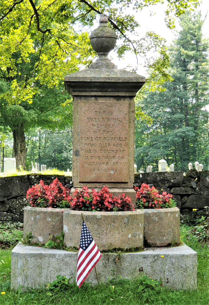
A monument for the War of Nationality, 1861-1865.
While jawing with some old-timers, I learn there’s a “really old” graveyard I should see on Norton Hill Road. As I pull up to Hill Cemetery, I can tell from the styles of gravestones that it’s no older than mid-19th century, but a war memorial right next to the road rewards the stop. Erected in 1867, it includes this wording: “TO THE EVER LIVING MEMORY OF THE SONS OF ASHFIELD WHO DIED FOR THEIR COUNTRY IN THE WAR OF NATIONALITY 1861-1865.” It’s the only place I have seen the U.S. Civil War described using this term.
At Creamery Road, I turn left toward South Ashfield then savor those curves on 116 to South Deerfield. It’s easy to bypass busy U.S. 5 via Lee Road and Mill Village Road to reach the Old Deerfield historic district. There, at the end of Albany Road, is another of Dad’s favorite graveyards, the Old Deerfield Burying Ground, c. 1690s (aka Old Albany Cemetery).
Some old graves, including these at Adams Cemetery in Wilbraham, are marked by both headstones and footstones, carved with complementary designs.
More than a dozen stones date back to the 1600s, the oldest one for Mary Blanchard, who had 10 children with her first husband, John Waite, and nine more with her second husband, John Blanchard. Notably, this graveyard includes a monument to 47 settlers killed during a raid on the town by native residents and their French military allies on February 29, 1704.
Walking the rows of stones, it’s intriguing to note how the styles have evolved over time. Early carvings with skulls gave way to skulls with wings, then winged angels, and then urns with weeping willows. Few parents still give their newborns names like these: Eleazer, Flavia, Zenas, Temperence, Dorcas, Ithamser, Arrethusa, and Thankfull Experience. Also here is a gravestone for a young woman whose name is hard to read without chuckling: Fanny Forward.
Leaving Deerfield, a short stretch north on U.S. 5 connects to another River Road, this one following the Connecticut River south to Mount Sugarloaf. Beyond the bridge, a right onto State Route 47 south follows the river’s other bank where harvested tobacco fields and the Mount Holyoke Range provide scenery.
It’s fitting that Dad is buried in one of the graveyards that so intrigued him.
Keeping to roads less traveled, I make my way through South Hadley, Belchertown, Ludlow, and Wilbraham, to Adams Cemetery, c. 1740. Gravestones here include dozens with epitaphs that speak to the difficulty of life and inevitability of death. Consider two:
“Friends and Physicians could not save, My mortal body from the grave.”
“Youth blooming learn your mortal state, How frail your life, how short the date.”
It’s fitting that Dad is buried here in one of the graveyards that so intrigued him – particularly one that is actively preserved and celebrated as a historical resource. Even if the graveyards in your neck of the woods aren’t as old, it’s likely they’re peaceful, beautiful, and interesting places to explore. When you’re enjoying a ride, take the opportunity to experience history in outdoor museums along the way. Explore old graveyards – on purpose.
Whether you’ve been riding together for years or share the road for just one day, the bond between riders always feels like family. (Photos by the author)
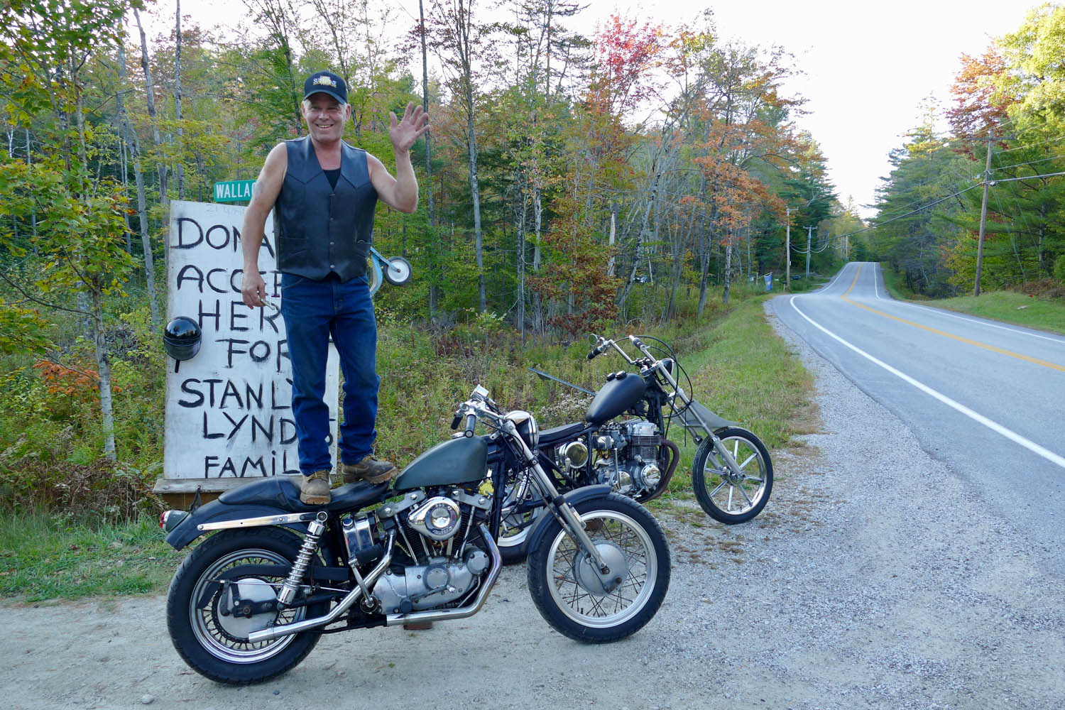
My obsession with the White Mountains and Kancamagus Highway in New Hampshire began nearly a year before I rode the famous route. I’d been testing BMW’s K 1600 B on a late-season ride on Vermont Route 100, just tootling along with all the Subarus, when I saw a guy on the side of the road standing atop an aged custom Harley, waving.
Curiosity got the best of me, so I swung the bagger around to meet Eric, a local mechanic, who said he was standing on his bike to get people to stop and make a donation for a friend and his wife who were in a motorcycle accident.
Route courtesy of New England Riders (NewEnglandRiders.org)
This would turn out to be Stanley Lynde and his wife, Laura, owners of Lynde Motorsports in Brattleboro, Vermont. There was an official GoFundMe webpage at the time, but Eric “didn’t do the internet.”
And his method seemed to work, with several people stopping by as we chatted, offering donations and well wishes. Eric, a veteran motorcyclist and builder who can no longer get out for big rides, was very emotional about the situation. When I asked him if there was something I could do beyond a donation, he promptly said yes, I could ride. Specifically, he requested I head up into the White Mountains and ride his favorite road, the Kancamagus Highway, in honor of the Lyndes.
And I tried. With all my heart. But a major storm blew in the next day, the only free day I had before returning the bike and flying home. Eric, his friends, and the road with the odd-sounding name were on my mind all winter long.
A COMMUNITY, NOT A CLUB
Late the next summer I was finally able to return to the Northeast, this time for a high-mileage test of BMW’s R 1200 RT. The Kancamagus, aka The Kanc (technically NH Route 112), topped my list of roads to explore.
I introduced myself to Eric as he stood on his Harley alongside Vermont’s Route 100. The chance meeting would teach me much about the fellowship of riders, including an induction into the New England Riders (NER) one year later.
I enlisted the help of Ed Conde, route master for New England Riders (NER, newenglandriders.org), an impressively large group (14,000+ strong on Facebook) that identifies as “a community of motorcyclists that self-organize to ride and have fun with other riders,” rather than a club, in which there would be things like dues and rules and officers.
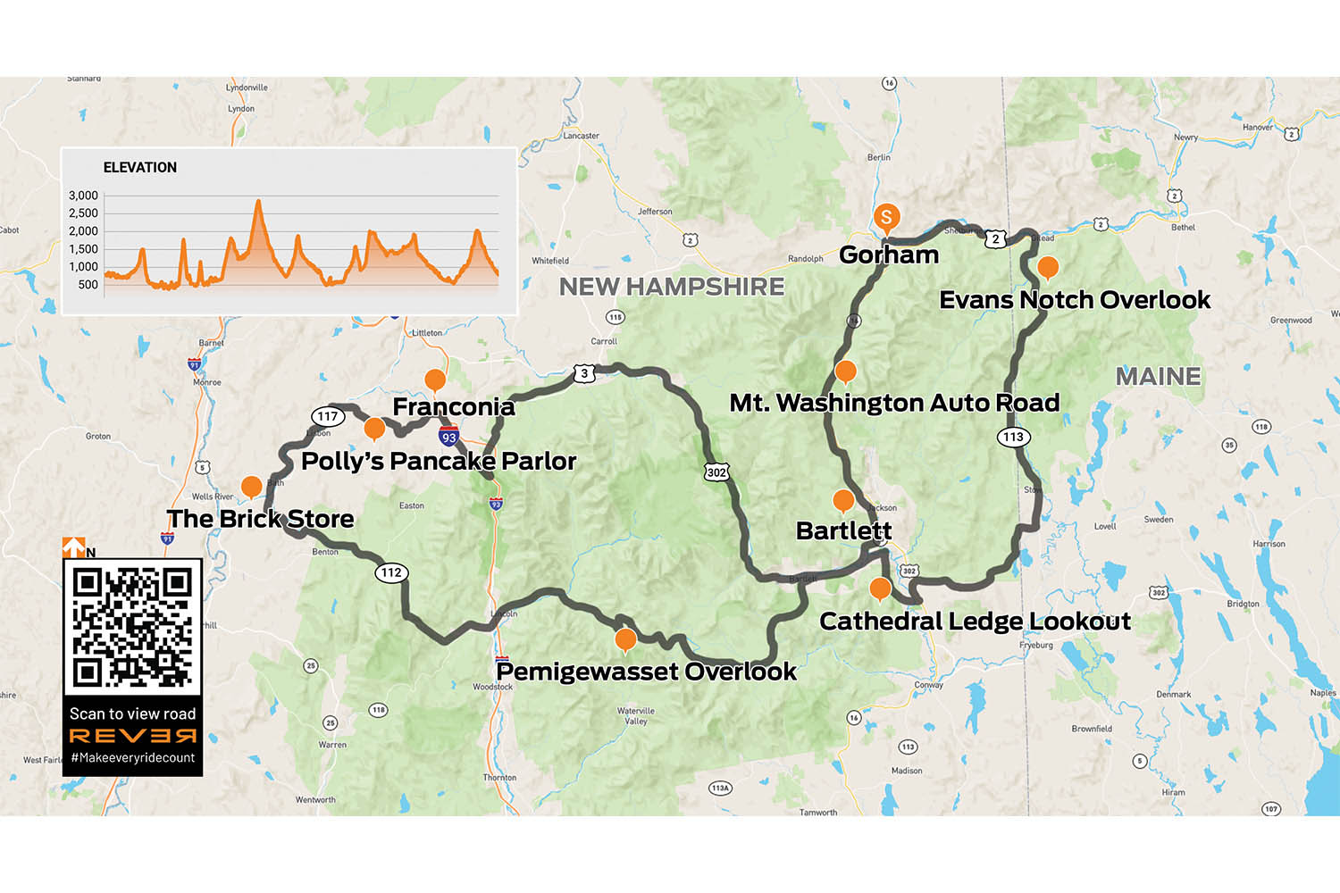
Now, I’m a solo rider by nature, but after getting to know Ed and his wife, Debbie, online, I was excited to meet up with them and a small crew of NER riders to follow Ed’s “Best of the White Mountains” tracks, a 202-mile double loop that launches from Gorham, New Hampshire.
It was a Friday morning in September when I throttled out of Gorham with seven strangers, tracing the Androscoggin River eastward on U.S. Route 2, then crossing into Maine to head south on State Route 113. This rural highway is where the party started, with the road beginning to curve and roll as it swept its way up into the White Mountain National Forest.
Right away, it was clear this group could ride. On the way to the meeting point, I’d been thinking, “Okay, be patient, this could be a long day, be on your guard…” – all the things one should remember when joining an unknown group of riders. When we stopped at Evans Notch overlook for a breather, I learned these NER members are skilled because most had invested in training and trackdays, many under the tutelage of Ken Condon, author of Riding in the Zone.
THE MASTER PLANNER
My new buddies, from left: Ed Conde, Steve Bruning, Mike Woods, yours truly, Bob Blethen, Laura DeAngelis Heinlein, Steve Gallant, Lisa Cheney, and Debra Conde.
The White Mountains, a roughly 90-mile segment of the much larger Appalachian Range, was created by western movement of the North American Plate more than 100 million years ago, long before the glaciers of the Ice Age covered them, then receded, smoothing sharp edges into the rounded notches and dished valleys we see today.
Our group was too early for the region’s famous fall colors, which suited these passionate riders just fine since it meant light traffic as we flowed down State Route 113. At Fryeburg, we followed Ed on a few quick turns to reach Hurricane Mountain Road, a narrow goat path of a backroad that constantly rises and dives, splashing through the densely forested hills, twisting just enough to heighten the senses.
Evans Notch on ME 113 is the easternmost pass in the White Mountains.
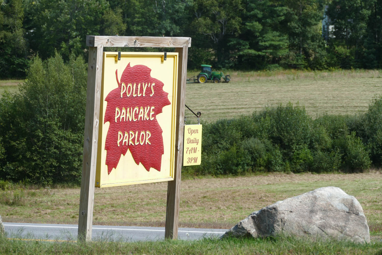
I swear I didn’t tell Ed that I’m obsessed with road-trip pancakes; it just happened this group feels the same. Polly’s potential for addiction is real, and I’m happy I live thousands of miles away. Most of us went with pancake “samplers,” where you order three short stacks (yes, per person!), mixing and matching different batters and mix-ins.
It’s at this point I realize Ed Conde is more than just a nice guy with some ideas about good roads. Ed is a purveyor of truly fine roads, the kind of gems you simply wouldn’t find and connect on your own. And as I’ll learn over time, his skills aren’t limited to cataloging premium strands of tarmac; Ed sews in all the best views, bathroom stops, and restaurants, too.
You can see for miles from the Cathedral Ledge overlook, one of many scenic stops on our “Best of the White Mountains” day ride.
It’s the secret stash a local rider might know, but Ed’s not a local here in New Hampshire. He and Debbie live near Boston, and it’s become their shared passion to travel on bikes – he on a Honda ST1300 and she on a Suzuki V-Strom 650 – exploring new states and creating a database of the best motorcycle roads, many of them stitched into day rides. Ed shares these elaborate ride plans and GPX tracks, which span from Nova Scotia all the way down to Alabama and Georgia, on the NER website.
It’s their way of giving back to the community, he says, for all the joy and treasured memories motorcycling has brought to their lives.
TIES THAT BIND
After conquering Hurricane Mountain Road, we traveled west on U.S. Route 302, taking time for a photo stop at the beautiful Cathedral Ledge viewpoint in Echo Lake State Park, before continuing to Bear Notch Road, another curvy delight with three worthy overlooks.
Road-trip pancake eating is one of life’s greatest pleasures, so a stop at Polly’s Pancake Parlor was more than welcome. Polly’s started serving the tasty cakes in Sugar Hill, New Hampshire, back in 1938 as a way to highlight their maple products. The maple spread is insanely delicious. Photo by Ed Conde.
Then finally, up ahead, the road sign I’d been envisioning for almost a year: State Route 112, the famous Kancamagus.
While no one I was with that day knew the reason behind my request to ride this particular highway, I was sure they would feel equally compelled by Eric standing on his old Harley, feeling helpless about his friend’s fate.
Since that chance meeting, I’d learned Laura had survived her injuries, but sadly, Stanley had not. I carried his family in my heart as I rolled onto the Kanc.
PANCAKES FOR LUNCH
Just as Eric promised, the views from Route 112 were glorious. The highway is well-kept and curvaceous, chasing after the Swift River like a blackbird mobbing a hawk.
When we stopped at the Pemigewasset Overlook, everyone was in great spirits, laughing and telling stories. I didn’t even stop to wonder how it was these strangers I’d met only hours before now felt like old friends. We’ve all felt it, that current of shared experience that so instantly connects riders when and wherever we meet.
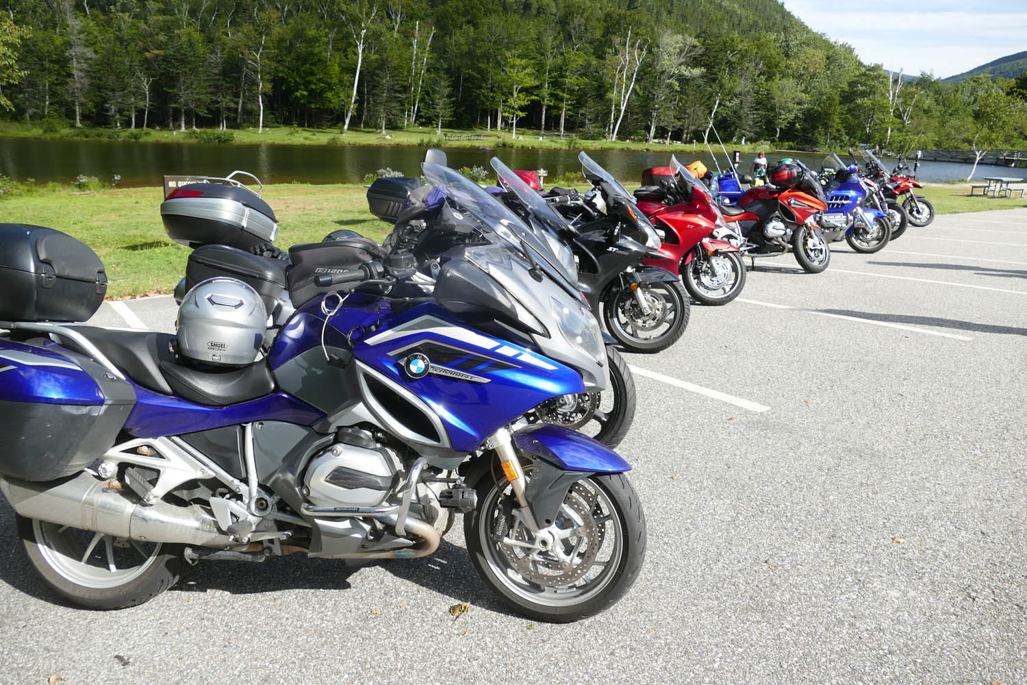
The NER group I rode with were on a variety of bikes, but the flavor du jour was definitely sport-tourer.
Unexpectedly, the ride only continued to get better as the day rolled on. Departing the Kanc, we reunited with Route 302 and headed east to Bath, where you’ll find The Brick Store, America’s oldest continuously run general store. The market is flanked by a popular ice cream shop, but we were headed for Polly’s Pancake Parlor on Route 117 for an afternoon feast of hotcakes and bacon.
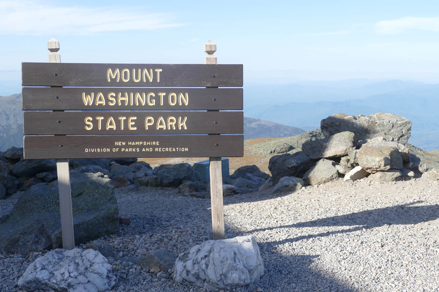
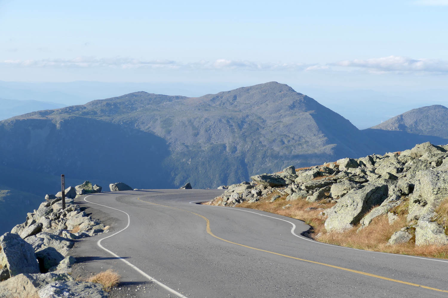
From Polly’s we headed east to Franconia and followed U.S. Routes 3 and 302 to link together alpine lakes and waterfalls, crossing over our westbound route around Bartlett. There’s plenty to see and do on this section, but we kept an eager clip so we could start up the Mount Washington Auto Road, the capper of Ed’s “Best of the White Mountains” ride, well before the toll road’s cutoff entry time of 5 p.m.
A SLICE OF HEAVEN
Mount Washington (6,288 ft) is the most prominent peak west of the Mississippi and the highest mountain in the Northeast, but what’s really neat about it is the road that takes you to the summit. It’s just 7.6 miles long, but man, the views are forever. The drop-offs are too, which can rattle some, even though the mountain is well controlled by low speed limits and heavy traffic.
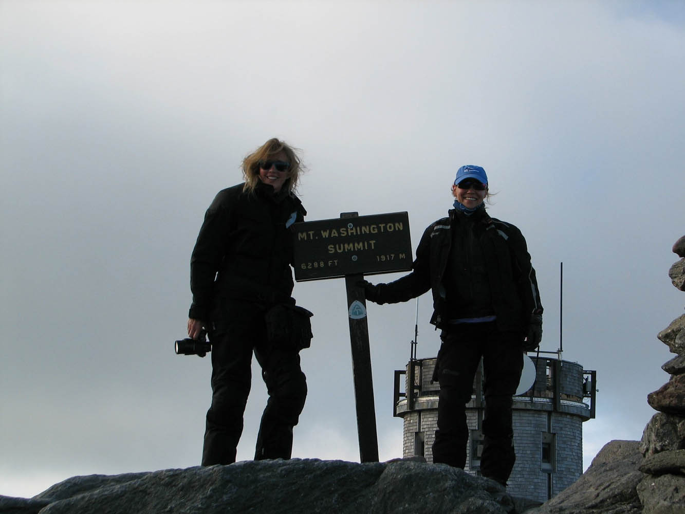
We arrived at the summit with just enough time to check out the museum and observation areas. This windy peak was also where I said goodbye to my new friends, since we’d head in different directions at the mountain’s base.
Those smiles on my and Lisa Cheney’s face sum up the feeling of riding up the Mount Washington Auto Road (photo by Steve Bruning). A sign at the bottom of the 7.6-mile road reads: “If you have a fear of heights, you may not appreciate this driving experience.” Riding makes it even more of a thrill.
After snapping an action shot or two of the group halfway down the now heavily shaded northeastern slope of the mountain, park trucks pulled up, urging stragglers like me toward the gates. On a whim I asked if I could ride back up – “super quick” – to get a photo of the empty road.
I was floored when the guys said sure, I could have the 20 minutes or so it would take them to usher the remaining tourists from the lower lookout points.
And so began one of the most striking experiences of my 36 years of riding. I had the top half of Mount Washington to myself. Its Auto Road, which had been clogged an hour before, was now empty.
And I’m proud to say I didn’t rip up and down the famous toll road as I would’ve in the past. Instead, I focused every bit of energy on soaking up a scene that looked and felt like a literal slice of heaven.
By this point, my White Mountains ride had become way more than a report about a day trip in New England. It reminded me that I’m part of a huge, ever-present family. Showed me that true friends can be old, or new, or only in your heart.
No matter how far we wander, there will be other riders to make us feel at home.
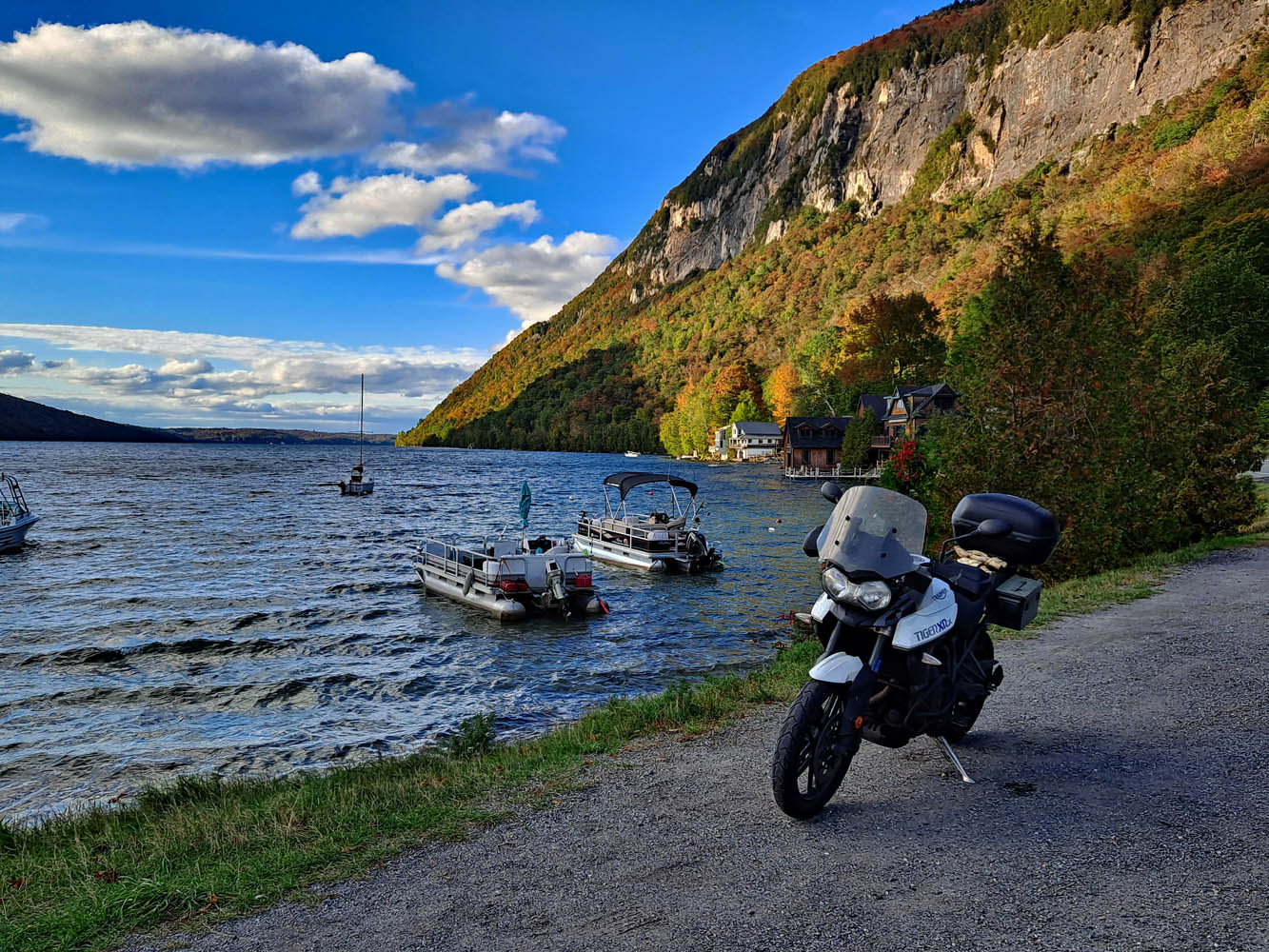
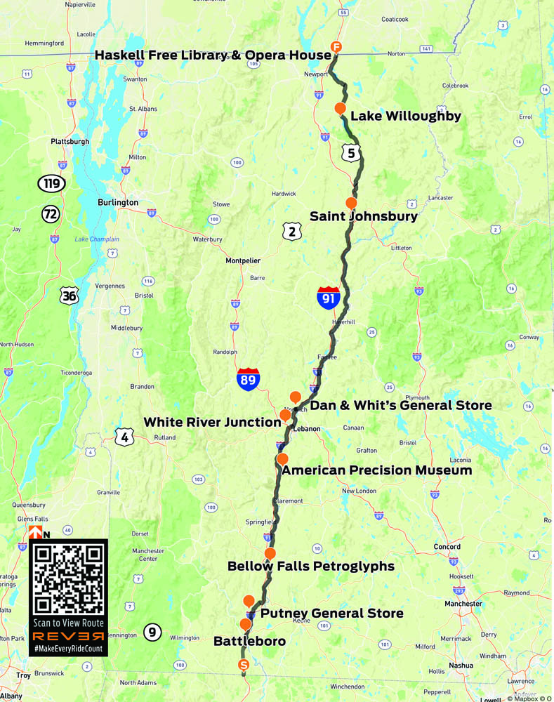
A few years ago, Rider published my article about riding Vermont Route 100 from south to north, ending at the Haskell Free Library and Opera House, which straddles the U.S./Canada border. Someone wrote a letter to the editor asking how I got back. U.S. Route 5 runs along the east side of Vermont, and it happens to be another one of my favorite rides. It has all the elements of a great motorcycle road: beautiful scenery, fine curves, light traffic, and nice places to stop along the way. For this ride, I am again starting at the Massachusetts border and heading north, but it can also be run in reverse.
I cross from Massachusetts into Vermont just south of Guilford, and the road almost immediately plunges into the woods, curling back and forth around the trees, a preview of what’s to come. First, I pass through Brattleboro. With 12,000 residents, it’s the largest town I’ll encounter today. Downtown consists of about three blocks of century-old brick buildings. It’s a little congested, but as soon as I clear the roundabout at the junction with State Route 9, everything eases up and I’m into rural Vermont in search of coffee.
Just one of the many wonderful curves on U.S. Route 5.
Putney General Store bills itself as Vermont’s oldest general store. It has creaky floors, good food, and – most importantly – good coffee. Properly caffeinated, I’m on my way, and U.S. 5 reveals its true character: rising, falling, and curving through the landscape. I lose myself in its rhythm.
These petroglyphs are believed to have been carved by the Abenaki hundreds of years ago.
In Bellows Falls, the falls don’t bellow anymore. The river was dammed in 1802 to aid with upstream navigation. Down near the river, a mysterious row of faces is carved into the rocks. The petroglyphs are believed to have been carved by the Abenaki hundreds of years ago. Curiously, a couple of the faces appear to have antennae. Evidence of an extraterrestrial visit? I ponder the question as I head out of town.
The Cornish-Windsor Covered Bridge is the longest two-span covered bridge in the world.
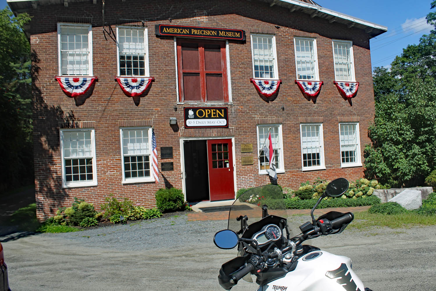
U.S. 5 resumes its swooping, twisting, and turning as it tunnels through the trees. Nothing is too tight or unexpected, just a wonderful ride, and I drink it all in. There is a zig and a zag in Springfield before the enjoyment continues to the American Precision Museum in Windsor. It’s housed in the Robbins and Lawrence Armory, where they developed the concept of interchangeable parts in the 1840s. One display in the museum is a belt-driven machine that turns gunstocks. As the blank for the stock spins, the cutters gracefully move in and out. The accompanying video is mesmerizing. In addition to many machine tools, they also have Bridgeport milling machine serial number 001 – if you’re a gearhead, you’ll understand its significance.
The American Precision Museum houses tools from the birthplace of modern manufacturing.
Past Windsor, the road resumes its rhythm as it carves up around a golf course. All along the way, I pass small farms with their quintessential red barns. Some have stands selling fresh veggies, and I pick up some tomatoes and sweet corn.
White River Junction, where the White River joins the Connecticut, has long been a transportation hub. The arrival of the railroad in the 19th century cemented its status. Today, it’s at the junction of Interstates 89 and 91 as well as U.S. Routes 4 and 5. All the amenities are near the highway interchange, and it’s easy to miss downtown, but with several restaurants to choose from, it’s a great spot for lunch.
One of the many small farms along U.S. 5.
A sign in the window at Dan & Whit’s General Store in Norwich declares, “If we don’t have it, you don’t need it!” Whether you are looking for an alarm clock or beer pong supplies, they have it. The paint department? It’s in a room behind the deli. Keep going and you’ll find a huge hardware section. The variety of stuff crammed into the space is remarkable, and it’s easy to get lost among the hams and hammers and hammocks.
Leaving Norwich, there is a change. The hurry is gone, and I glide effortlessly around the curves, passing by narrow valley farms and through the villages of Thetford, Fairlee, Bradford, Newbury, and Wells River. In Barnet, there is another perceptible change as U.S. 5 parts ways with the Connecticut River and starts following the smaller Passumpsic River. The curves are tighter, the hills are closer, and at one point, U.S. 5 slips between the northbound and southbound lanes of I-91 for a bit.
There is a “North Country” feel here close to the border.
In St. Johnsbury, State Route 5A splits off as it passes the St. Johnsbury Athenaeum and the Fairbanks Museum & Planetarium. Both 19th-century edifices were built by the Fairbanks family. Their Fairbanks Scales Company changed how commerce was done, and the family spent much of their fortune locally. Fine Victorian architecture lines both sides of the road here.
After Lyndonville, U.S. 5 cuts through the landscape to West Burke, where I follow State Route 5A toward Lake Willoughby. The lake is the crown jewel of this ride. Nestled between Mount Pisgah and Mount Hor, it resembles a Norwegian fjord. The road runs up the east side, perched precariously between lake and ledge.
With the border just ahead, it’s time to turn around.
Past Lake Willoughby, there is a “North Country” feel. The rivers flow north toward the St. Lawrence River, the landscape is more open, and the trees seem shorter. Route 5A reconnects with U.S. 5 in Derby Center and heads for the Canadian border at Derby Line. There, within sight of the Haskell Free Library and Opera House, not far from the border, is a sign that declares “End 5.” Just beyond is Quebec and a large sign that says “Bonjour.” It’s time to head back. Maybe I’ll take Route 100.
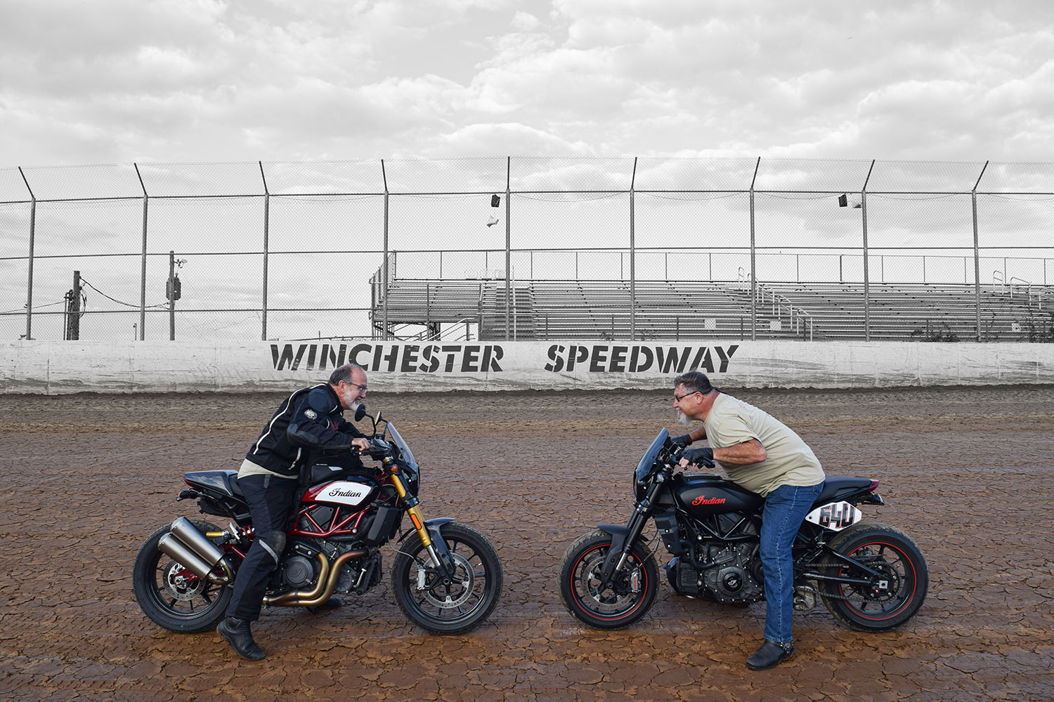
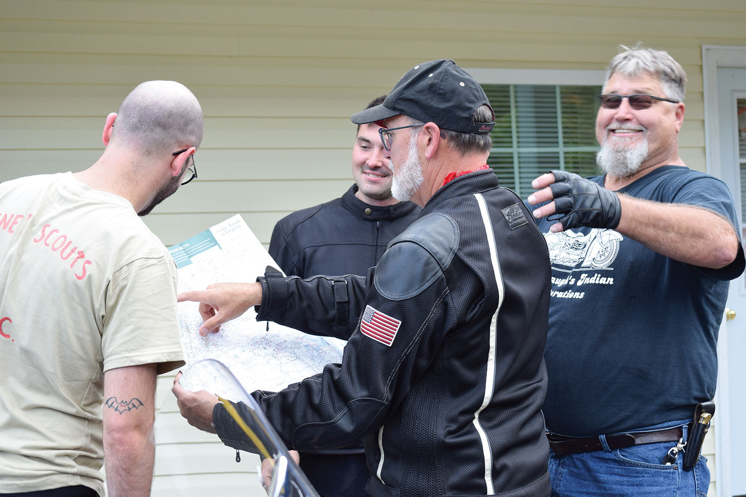
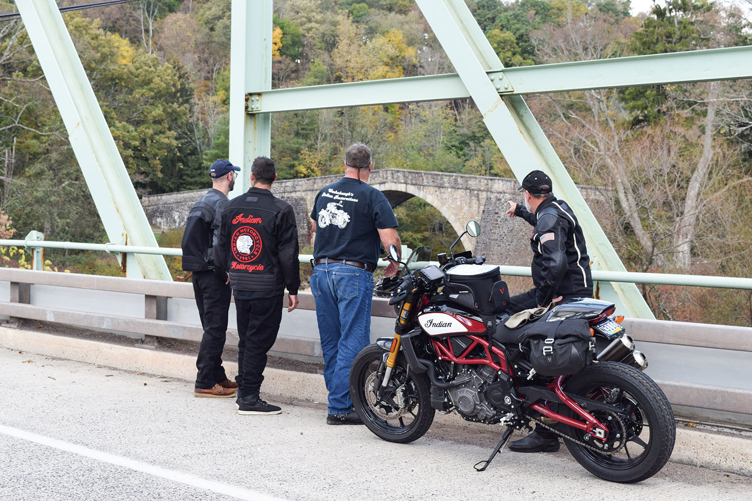
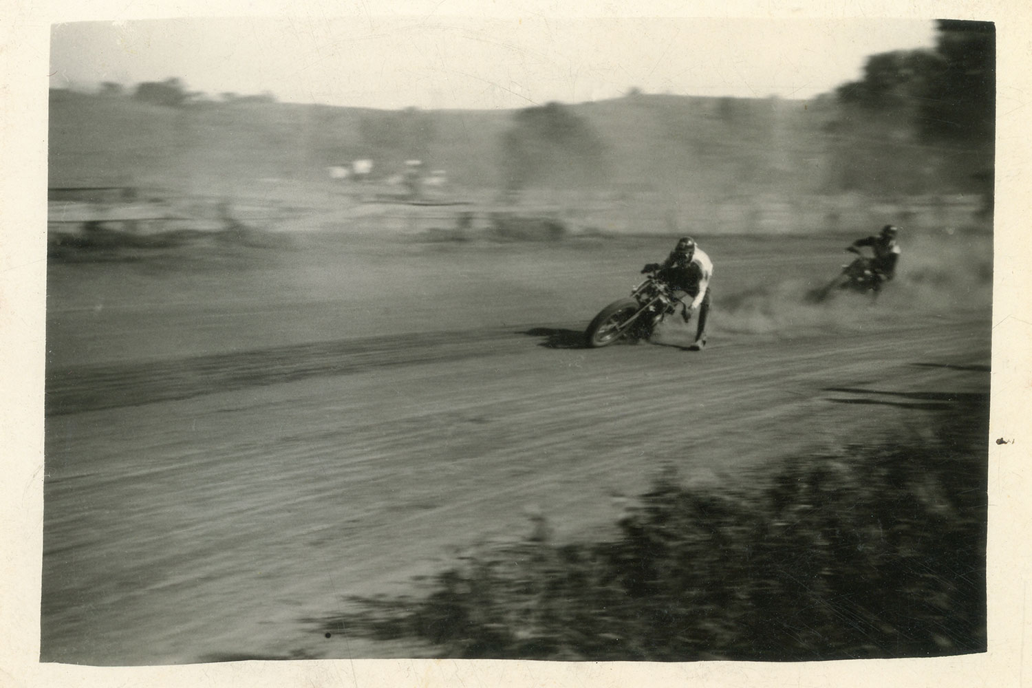
Eric Trow and Ron Washabaugh face off on the same clay their grandfathers raced on more than 70 years earlier (below). Contemporary photos by Hal Deily, archival photos courtesy of the author.
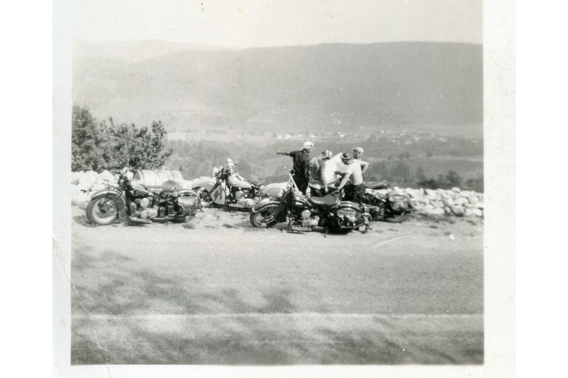
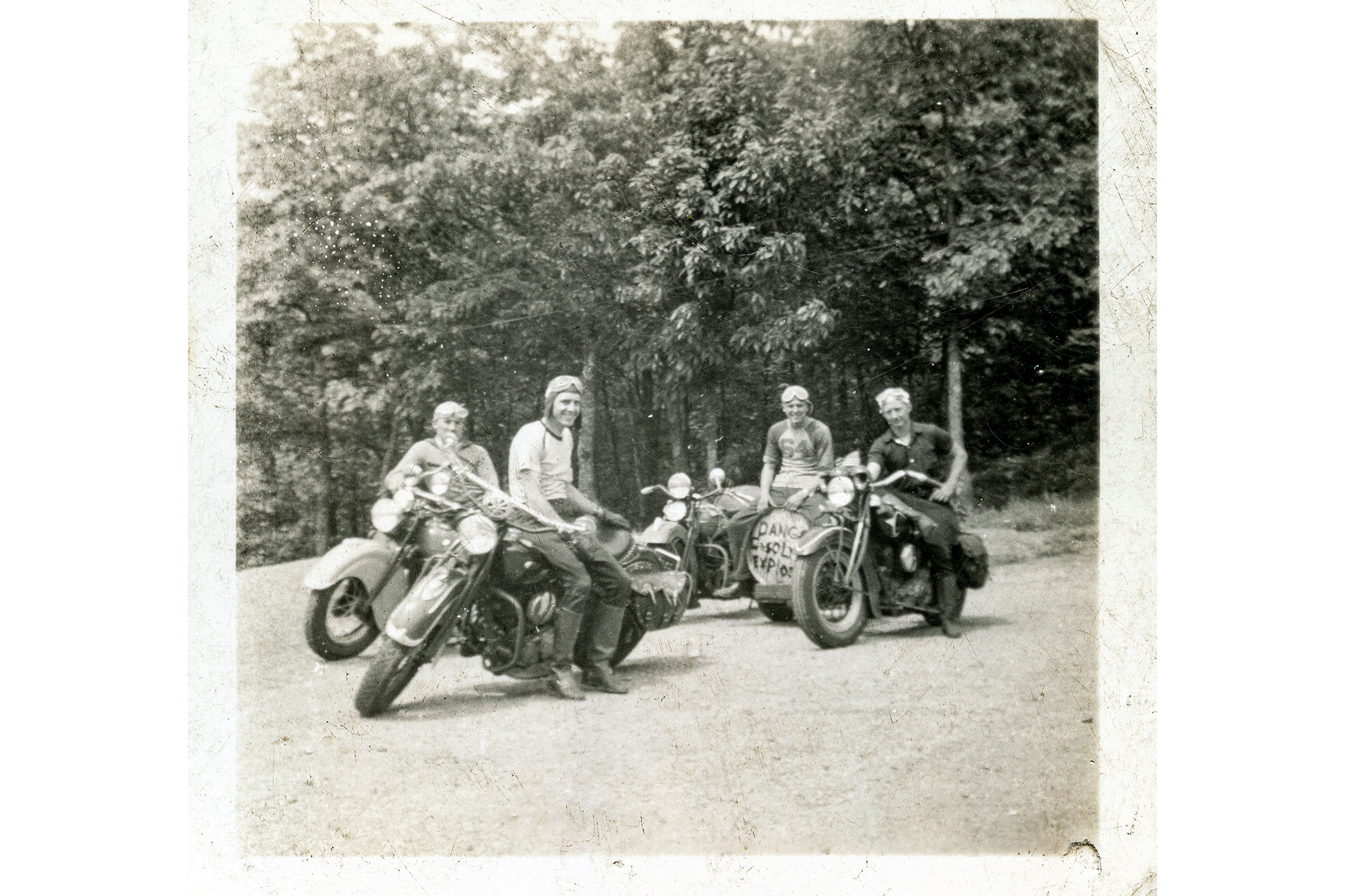
At a time when American riders were fighting the Harley and Indian wars, Gene Townsend and Floyd “Washie” Washabaugh were unflinchingly Indian men. It was rumored their blood flowed a bit more maroon than the rest of us, having the distinct deep shade of the brand’s signature Indian Red color.
Over the years, the two men defended the Indian brand on dirt tracks across Pennsylvania, Maryland, and Virginia. Gene, my grandfather, born in 1908, spent most of his racing years on an Indian 101 Scout sporting the #9 plate. He was a top regional amateur racer from the mid-1920s on into the war years, only to retire when a brush with a #6 bike sent them both through a fence.
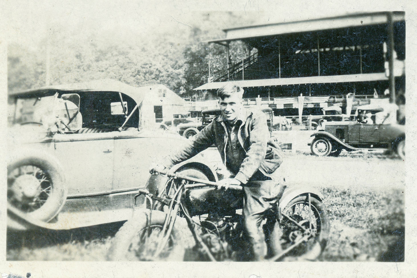
Gene Townsend before a race on his highly tuned Indian 101 Scout.
The radio announcer covering the event mistook the upside down #6 machine as the #9 and mistakenly reported that Gene Townsend had been rushed to the hospital with serious injuries. My grandmother and her young daughter (my mother) were beside themselves when they heard the broadcast. Gene promised to never worry them again and quit racing on the spot. Washie, five years his junior, competed successfully on Indian Sport Scouts through the mid-1950s, and even had a short stint as a professional racer with Gene’s backing.
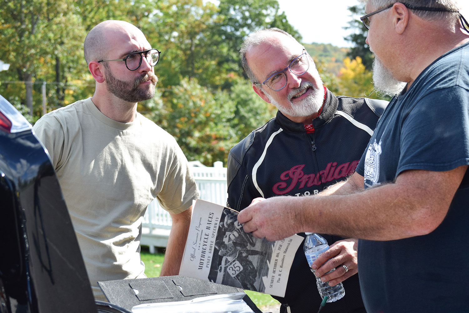
Parker, Eric, and Ron leaf through a period racing program along the road to Winchester.
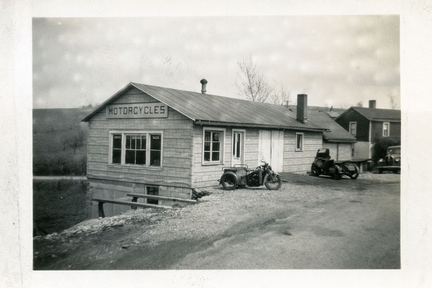
By 1948, Gene had owned his southwestern Pennsylvania Indian agency (what dealerships were called back then) for about 20 years. He had built his reputation as an exceptional rider and racer as well as an expert tuner. If Indian riders wanted the hot setup, Gene was the guy to see. Washie was granddad’s close friend, a fellow racer, and a fixture at the old shop. They shared a passion for three things: Indian motorcycles, racing, and storytelling.
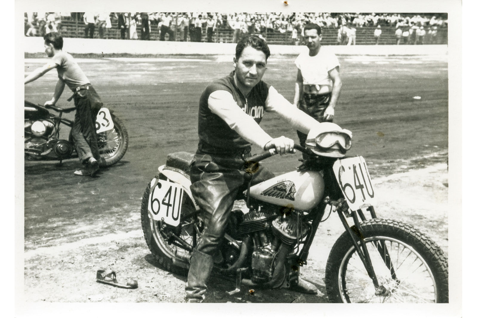
Floyd “Washie” Washabaugh aboard his #64U Indian Sport Scout racer in 1948.
I only knew Washie as an older man who rode his flashy old Indian Chief to my granddad’s shop. But I envisioned him and Gene as the vibrant and courageous young dirt-track racers in the old, dog-eared photographs taken in their racing days. The deep connection I developed with these older men was something I thought only my brother and I knew. Then I heard about Washie’s grandson, Ron.
We may have met at some point at the shop when we were kids, but Ron Washabaugh and I didn’t know each other. About three years ago, we met while attending the American Flat Track races at Williams Grove near Harrisburg. We immediately hit it off and began swapping stories of that magical old motorcycle shop and the deep appreciation and fondness we had for our grandfathers.
Some sections of the old National Pike haven’t changed much since Gene and Washie rode them.
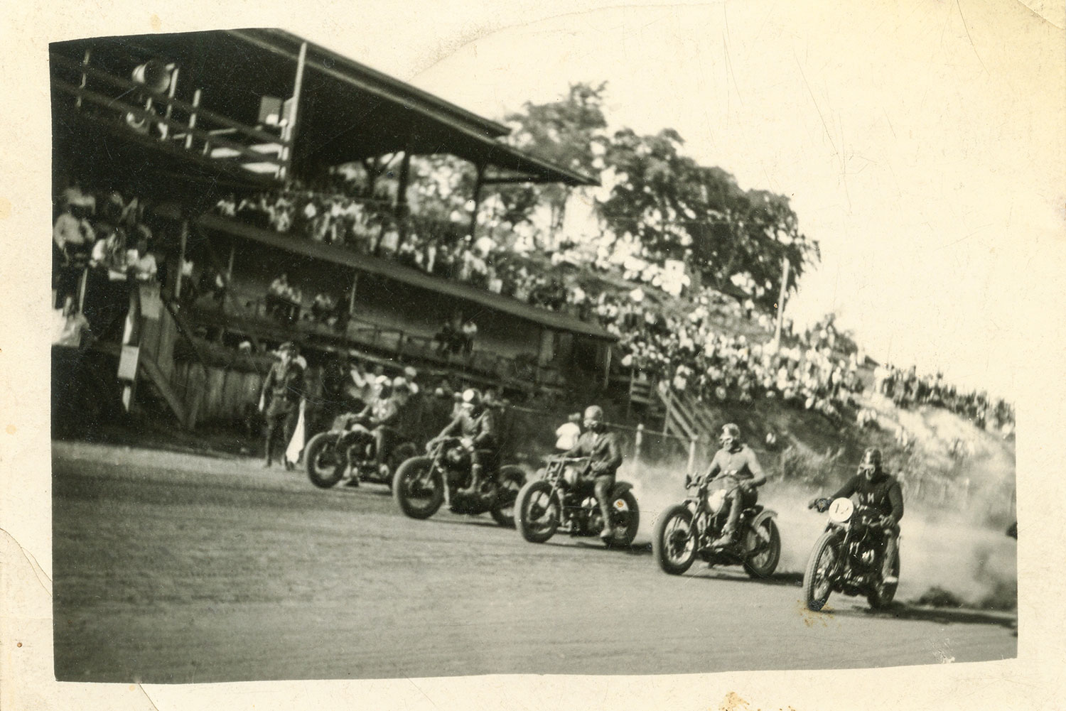
The most powerful memories for Ron and me were the racing tales told so passionately by old Gene and Washie. Through their words they painted vivid pictures of handlebar-to-handlebar racing adventures aboard their Indians on myriad local dirt tracks, as well as more distant venues such as Cumberland, Maryland, and Winchester, Virginia. They would either stuff a bike into the back of a sedan or ride their Indian Scouts to a track, remove the headlights and fenders to race, and then reassemble everything for the ride back home afterward. If they weren’t racing, they were organizing rides to watch others compete, like legendary AMA Hall of Famer “Iron Man” Ed Kretz at the Langhorne, Pennsylvania, track where he dominated the mile oval.
Stepping away from the digital GPS and iPhones, a vintage paper roadmap is used to chart the path the way their grandfathers (and great-grandfathers) would have done (below). It was a bit easier for the two older guys in the group.
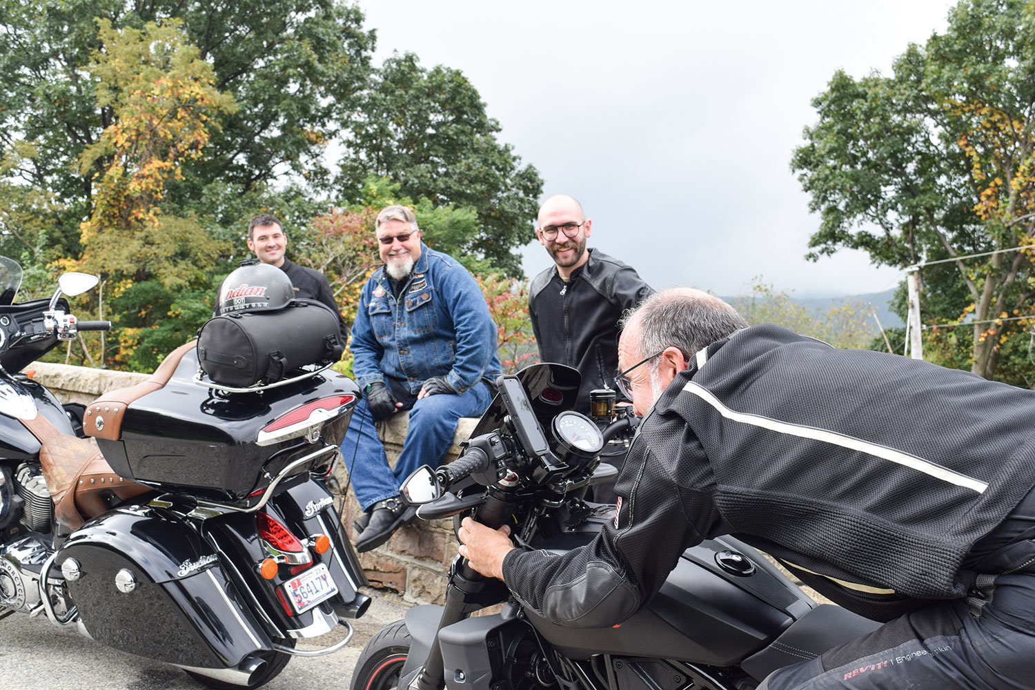
Ron and I decided to retrace Gene and Washie’s path to one of the legendary tracks they rode to back in the late 1940s and early 1950s.
Ron and his son, Steven, and me and my son, Parker, conspired to chase Gene and Washie into the past on a journey to the old Winchester Speedway. As grandsons and great-grandsons, we would emulate the experience the two elders had back in the day. We would ride the National Road (U.S. Route 40) and other two-lane roads, stop where they might have stopped, eat at family-owned diners along the way, and find classic roadside motor lodges where they might have stayed. At every opportunity, we would celebrate their story and, at the same time, get to know each other and forge another generation of bonding around a common passion for motorcycles.
After a sprint up the mountain, the overlook atop Summit Mountain on Route 40 was a popular stop for the old boys.
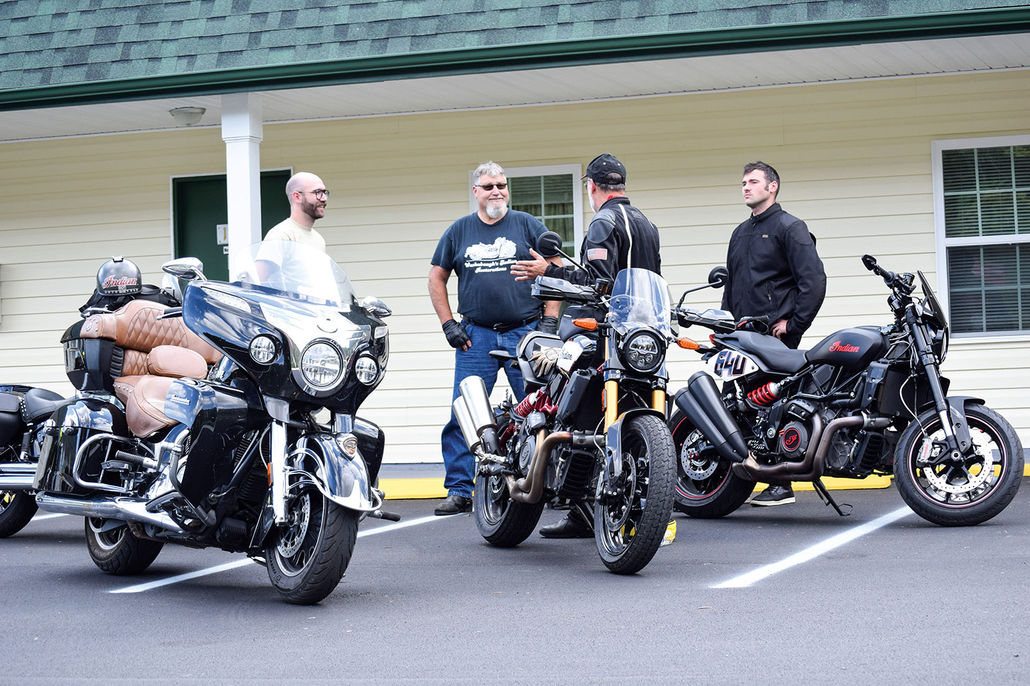
Ron and I both have vintage Indians, but for this excursion Ron was aboard his modern Indian Roadmaster, and I piloted my Indian FTR 1200 S Race Replica. Stephen rode his new FTR 1200 as well, complete with a number plate bearing his great-grandfather’s racing number, #64U. Parker rode a 2018 Harley, just for a little tension in the spirit of that old brand rivalry. (The H-D Heritage 114 is mine, and so is the kid; both are terrific, and any ribbing was in good-spirited fun.)
Eric shows the kids proper tuck technique for flat track.
Last October, the Washabaugh boys met my son and me at a diner not far from the old shop. We ordered breakfast and gobbled up the vintage photo albums Ron brought with him. Although the food and conversation were delicious, we needed to get our planned adventure rolling. There would be more time to talk along the road, so we paid the tab and headed to the old Townsend cycle shop. The unexceptional building still stands (barely) just off the National Road, three miles east of Brownsville, Pennsylvania.
Washie straddles a sidecar-mounted drum of fuel used as a rolling gas station.
The modest shop was a hub of activity in its day, a gathering place where riders regularly came and went. Some visited to see what new machines and accessories had arrived. Others stopped by for a set of points, a condenser, and maybe a pair of spark plugs on their way through town. Most wheeled in for the conversation and the stories.
It was also the headquarters and ride origination point for members of Gene’s Scouts Motorcycle Club, an AMA-sanctioned club that served as the local riders’ social group and the sponsoring organization for motorcycle competitions. Washie raced as an AMA pro for one year under the Gene’s Scouts M.C. banner. Unfortunately, after just one season, the cost proved to be too steep, and he returned to amateur racing. Some things never change for aspiring racers.
Racing at Winchester included flat track and this TT race with hills and a jump.
Soon, the engines of our Indians (and Harley) fired to life in front of the old shop, echoing the hundreds of Indians that had gone before from that same spot.
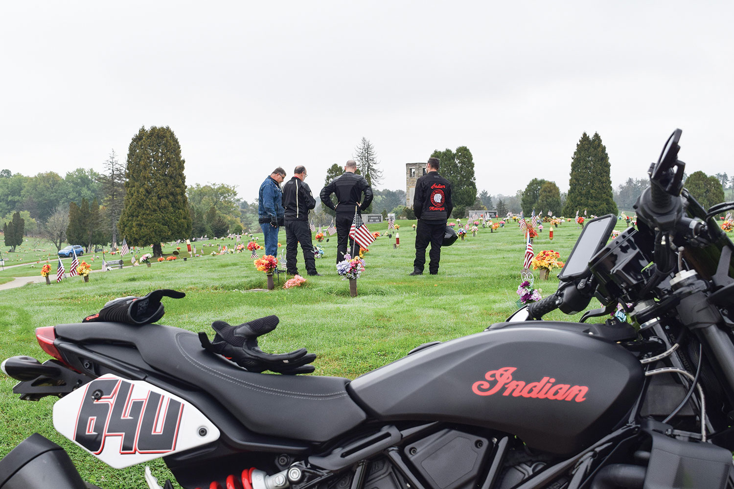
We rolled out of the parking lot and onto Route 40. The first planned stop was just up the road at LaFayette Memorial Park, where we paid our respects at Gene’s and Washie’s family plots. We thanked them for the tremendous influence they had on our lives, saluted their adventures, and invited them to ride along with us inspirit as we retraced the path they took seven decades earlier.
Gene’s Indian agency in the early 1940s.
Back on the road and heading east on the National Road, we approached Uniontown. I thought of the story Gene told me about a board-track motordrome speedway that was built there for motorcycle racing in the late teens of the last century. As a boy, he would climb a tall tree outside the grounds just to catch a glimpse of the racers flying by on the large, steeply banked wood-plank track.
Indians gather once again in front of the old Indian shop (apologies to the author’s son on the Harley).
Although the multilane highway now bypasses the towns, we took the old route that Gene and Washie would have followed through downtown Uniontown and Hopwood. We rejoined the highway on the other side where the pavement abruptly angled skyward, ascending Summit Mountain. Back in the day, this was a narrow two-lane ribbon that wound tightly up the steep hill – a rider’s dream. This stretch was the subject of many of the old timers’ stories as they recounted how they raced each other up the steep, twisting curves to the crest of the hill. They heeled their Scouts and Chiefs over so far into these corners that the frames would drag, levering the rear wheels off the ground momentarily. The trick, they said, was to hold the throttle open and let the bike reestablish traction without upsetting the chassis. Easier said than done!
Members of Gene’s Scouts M.C. at a gas stop during one of their organized rides.
Today, the road is a four-lane divided highway tracing the original circuitous path. Ron, me, and our boys turned up the wick on our machines as we ascended the hill. It was a hoot to drop down a gear and put ourselves, at least mentally, alongside our grandfathers and great-grandfathers on a spirited sprint up the mountain.
The old crew would have likely crossed this stone arched bridge along Route 40 on their way to Winchester.
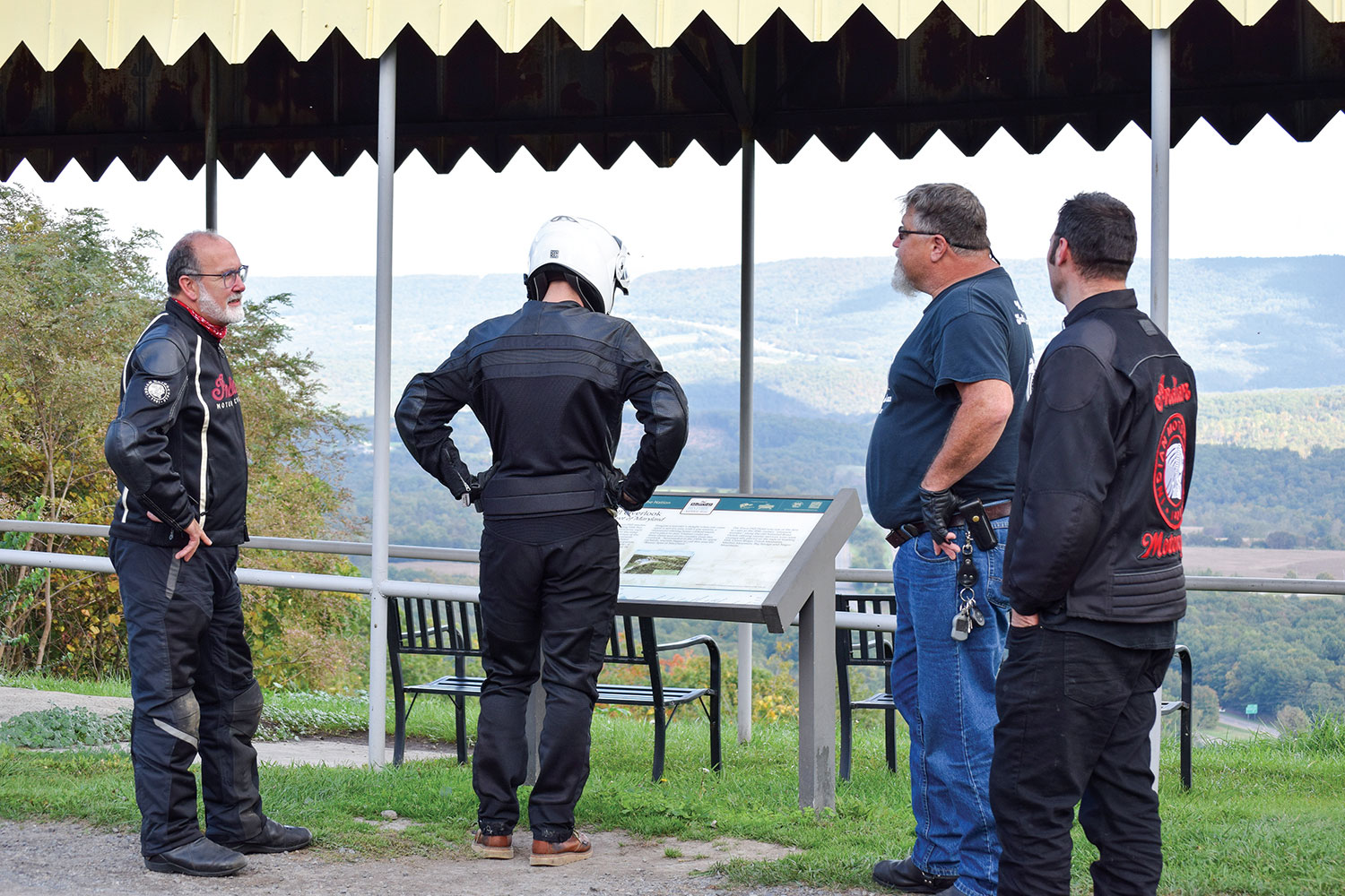
As we approached the summit, I signaled and the four of us wheeled off I-40 into the lookout at the peak of Summit Mountain. This was a spot where Gene, Washie, and the rest of their crowd regrouped countless times over the years. Summit Mountain was not just a road they took on the way to somewhere else, it was their local destination for sport riding. It’s where the guys tested their latest tuning and hop-up tricks. It’s where local Indian and Harley riders found out whose machine had the “soup” to capture the king-of-the-hill title for that week.
A typical overnight stay for the boys back in the day.
Ron and I used this pull-off to tell our sons stories we’d heard about this road and their great-grandfathers’ motorcycling adventures. We took turns contributing our own recollections, helping each other connect the dots where there had been gaps in our individual knowledge. Parker and Stephen stood by, soaking it all in.
Surely Gene and Washie would have stopped for the overlook at Town Hill.
Back on the road, we imagined the roadside stops the men might have made along their way. We proposed where they may have paused to stretch their legs, consult a map, check chain tension, or maybe add a quart of oil. Then we’d stop too. We took advantage of those roadside breaks to look through collections of old racing photos, racing publications, and pictures our grandfathers and their pals had taken along the road to different racing venues.
The Clarysville Motel in Frostburg, Maryland, has been operating for 100 years.
On occasion, we saw a turnoff to Old Route 40, most often a short spur of narrow two-lane that soon rejoined the newer main road. It was fun to ride a few of these old sections to capture the ride experience Gene and Washie had, but it was impractical to take each little detour. Other times we saw sections of Old Route 40 that were no longer accessible, including an area where an old stone arched bridge was once the path of the old National Pike. Gene and Washie probably traveled that same old stone bridge on their way to Winchester. We could only view it from the main road.
We paused at the old Clarysville Motel that looked like it might have been there when our grandfathers rode through. As it turns out, the place has been serving travelers for nearly 100 years. Other than the modern vehicles in the parking lot, it would be hard to distinguish 2021 from 1948 or earlier. Certainly, Gene and Washie rode by here many times, and may have even stayed on occasion when daylight expired.
The inn at Town Hill, Maryland, would have likely looked the same for the Gene’s Scouts crew in the 1940s.
In Maryland, the old highway began to rise, fall, and twist dramatically. This was the kind of road on which the boys surely had the old Indians dancing. They would have been intimately familiar with this fun section of road, knowing what lay ahead and anticipating it well in advance. After navigating a particularly enjoyable stretch, we crested a hill to discover the historic Town Hill Inn and overlook. This was a likely rest stop for Gene and Washie along their ride. It was a natural place to take a breather, check over the bikes, and enjoy the spectacular view across the wide valley below.
When not on the track, Gene’s Scouts were in the stands to watch their buddies race.
In Hancock, Maryland, we picked up Route 522 south and rode through quaint, historic Berkeley Springs, West Virginia, and on south into Virginia to our destination of Winchester.
Once in downtown Winchester, Ron led us to an iconic spot for a hot dog. Whether Gene and Washie ever stopped at this historic stand for a dog when they were in town, we’ll never know. But just in case, we thought we’d better have one since we were trying to capture the experience.
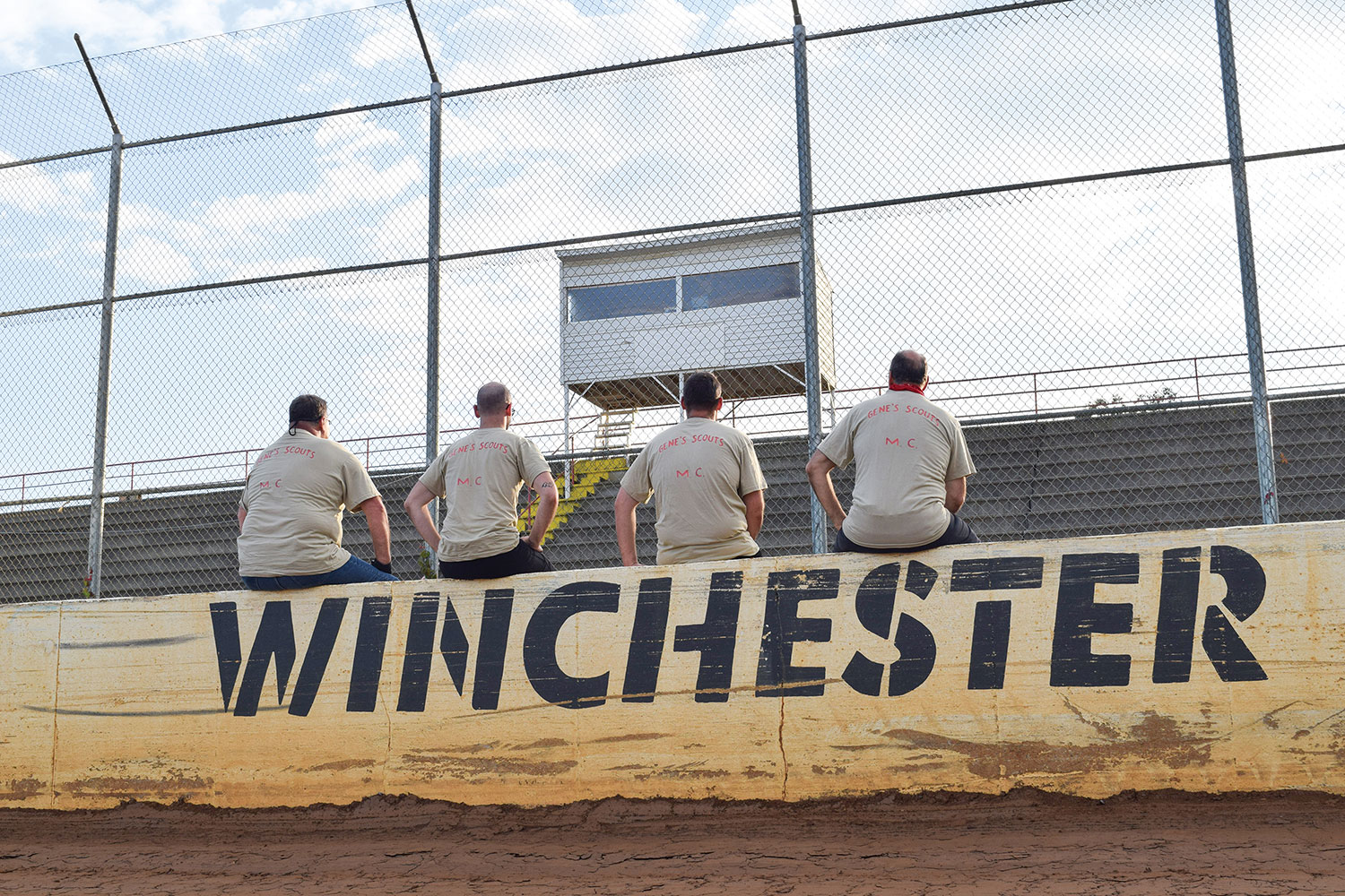
Grandsons and great-grandsons pause at the Winchester track to reflect on two diehard old racers.
Since the Winchester Speedway is sometimes referred to as the old airport speedway, we meandered through the town following directional signs for the airport. After working our way along narrow roads that wound around the airport property, we came to the end of the road and were unexpectedly at the back side of the racetrack. No big sign. No grand entrance. As a lot of these rural speedways were, it was simply a venue where people gathered. The raceway was probably not much different than it was when Gene and Washie were last here together, except now the old wooden grandstands are gone, replaced with concrete and metal.
Gene carves up the clay on an Indian Scout.
The beauty of these local facilities is how approachable the track personnel can be. We arrived midweek in the middle of the day and told our story. Hoping to have a picture taken outside the track at the speedway sign, our plan was thwarted when we realized there was no such sign and no suitable backdrop. Fortunately, the track folks invited us to bring the bikes onto the track and position them in front of the wall on the back straight where “Winchester Speedway” was painted in bold lettering. It was perfect. Ron couldn’t resist the temptation to ride around the dirt track just to run tires on the same clay that his grandfather once tore up on the #64U Indian Sport Scout.
A lineage of Indian men chased their ancestors Gene and Washie to Winchester Speedway to rev up their legacy for another generation.
We were all having a great time and didn’t want the adventure to end, but the autumn sun was already sinking low in the sky. With our mission completed and an abundance of pictures taken to commemorate our expedition, it was time to say our goodbyes. Ron and Stephen had about a two-hour ride east to get back home. Parker and I needed a bit longer for our westward trek on modern interstate highways back toward Pittsburgh.
On the way home through the darkness, I replayed the ride over again. In my mind, I overlayed images of Gene and Washie from 70 years ago on today’s images of Ron, Stephen, Parker, and me riding the same roads to Winchester. It felt good to ride with other descendants. It felt even better to be together, chasing Gene and Washie.
The ride began with a visit to the resting places of Gene and Washie. They were then invited to ride along in spirit.
POSTSCRIPT
As much as the Indian boys would love to hear that the Harley broke down so often that we were forced to abandon our plans (or abandon Parker), the Heritage 114 did just fine. While it’s fun for us to see the old Harley and Indian wars heating up once again in this modern era (we can hear Gene and Washie piping in from the great beyond), the real benefit of that rivalry has been the development of better motorcycles from both brands. A little competition is a good thing, though Gene and Washie would still give Indian a slight edge. After all, it’s in their blood.
Connecticut Route 43 has new tar, which encourages a pace Muriel would not have preferred. Photos by the author.
She’s taking her first ride on a motorcycle. Posthumously, as it turns out, but my Aunt Muriel is along for the ride, her ashes secretly stowed in my top case.
Muriel had not been a fan of motorcycles. She found them too fast and noisy and their riders too careless and selfish. For decades she lived near the coast in south Florida where a grid of congested, multi-lane streets put motorcycles right next to her. The ones she encountered, at least the fast and loud ones that stood out in her mind, didn’t give her much to like.
East River Road in Riverton, Connecticut, winds along the Farmington River through People’s State Forest. Muriel’s ashes are along for the ride, stowed in my top case.
While she enjoyed hearing stories of my long-distance adventures on motorcycles, she always made one thing quite clear: “You will never get me on a motorcycle!”
Now, as the miles are adding up, a thought keeps bouncing through my brain: Would Muriel have found this ride okay?
Muriel with Steve Efthyvoulou (right) and your humble scribe on one of our two-wheeled visits to her home in the North Carolina mountains.
Her attitude about motorcycles and their riders evolved after she retired and moved to the mountains of western North Carolina – one of the best motorcycling regions anywhere. When Muriel first took up residence in the town of Franklin, my wife, Sheila, and I drove down for a visit. Muriel drove us to lunch at a barbecue place she liked in the town of Highlands.
As we motored south on State Route 28, the road became tremendous, with baby’s-bottom-smooth tar and continuous tight turns, nicely banked. On one side of the road were jagged outcroppings, and on the other a fast-moving river in a rocky ravine. She pulled her car into a lay-by and drove us behind a waterfall.
On U.S. Route 221 west of Blowing Rock, North Carolina, a face seems to be emerging from the mountain.
Muriel was not what you’d call an expert driver, but to her credit, she stayed in her own lane on this intensely curvy road. Sheila was pregnant at the time and sat nervously in the back seat, clutching her rounded belly and hoping our destination was close. In stark contrast, I was thinking how fantastic this road would be on a motorcycle. I mentioned this to Muriel, and she suggested I come back riding one. “Bring a friend,” she said. “More than one if you like.”
This invitation, I later learned, was despite a homeowner association rule that did not allow motorcycles in Muriel’s neighborhood. “I don’t have a motorcycle,” she explained, “but if visitors come to see me and arrive on their cycles, there’s not much I can do about that, is there?” Muriel believed that it is easier to ask for forgiveness than permission.
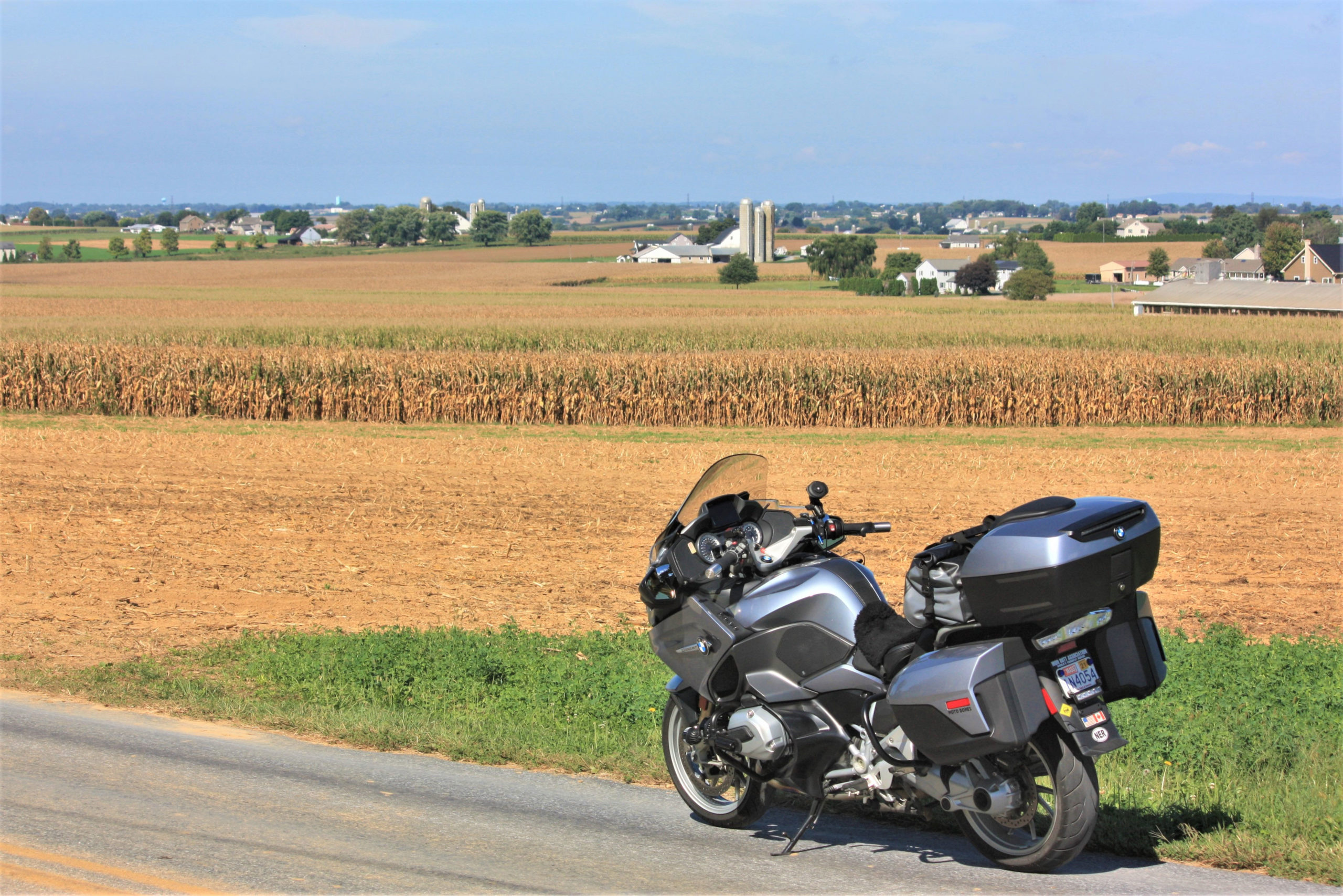
Our bikes cast early morning shadows on corn ready for harvest in Franklin Township, New Jersey.
Over the next 15 years, I took every opportunity to visit her with one, two, or three friends on motorcycles. We would arrive on quiet Hondas and BMWs, ride slowly through her neighborhood, and offer a friendly wave to anyone we encountered. Forgiveness was never required.
Muriel’s home was on a hilltop, providing an impressive view of the mountains where those roads we came to ride lay waiting. Her neighborhood emptied onto Route 28 (aka Moonshiner 28), and gems like Wayah Road, the Cherohala Skyway, U.S. Route 129 (Tail of the Dragon), and the Blue Ridge Parkway were there to be enjoyed. On every visit we discovered new roads.
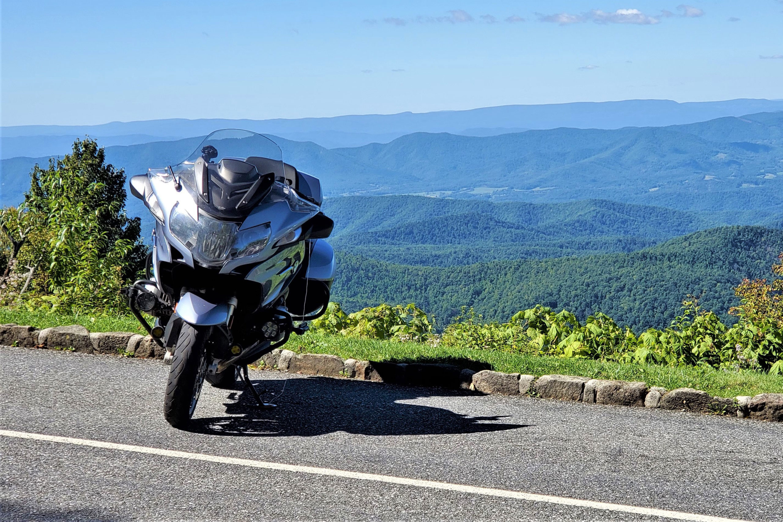
Where the Skyline Drive ends, the Blue Ridge Parkway begins.
We’d return from a day’s ride excited and full of stories, then take Muriel out for dinner. Over these meals, she got to know an orthopedic surgeon, a military logistician, a powerplant engineer, a metal fabricator, a warehouse manager, and a truck driver – each a gentleman, a gracious guest, and a motorcyclist.
Steve pilots his Honda ST1300 through a corridor of corn.
One time Muriel casually asked if we’d help her change out the storm windows for screens. “You’ll keep an old lady off a stepladder,” she explained. We installed those screens, and on every subsequent visit we asked for her honey-do list. Leaky faucets, wobbly towel bars, and uncooperative wi-fi never stood a chance. Muriel came to appreciate that not every motorcycle was too fast and noisy, nor every rider too careless and selfish. When talking with her church lady friends, she referred to us as her gentlemen friends on motorcycles.
This Lancaster County, Pennsylvania, Labrador pup approached us in full wag mode but was quickly corralled by his protective mother. (Good dog.)
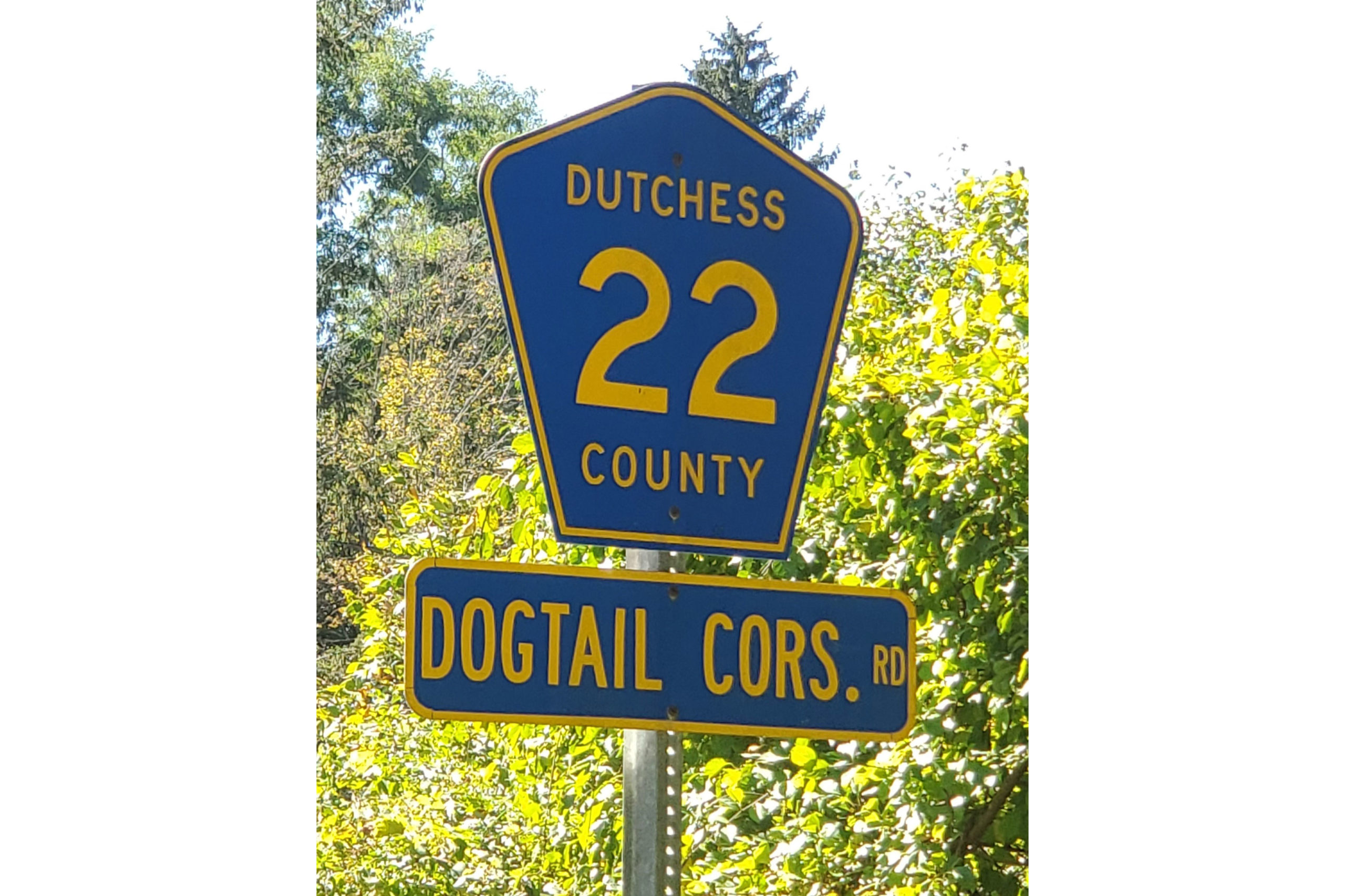
Now, on a warm Sunday at summer’s end, I depart my home in western Massachusetts and point my BMWR 1200 RT south and west. Weaving through the Berkshire Hills of Connecticut, I seek out places Muriel would have liked: Saville Dam in Barkhamsted, East River Road overlooking the Farmington River, and historic covered Bull’s Bridge across the Housatonic River. At the New York border, the road becomes Dogtail Corners Road … Muriel would have chuckled at the name. She would have been less amused by the 10-mph hairpin turns on Dutchess County Route 22 east of Pleasant Ridge Road, but I lean in to savor them.
Muriel would have chuckled at the other name of Dutchess County Route 22 in New York State.
I curve through the Bear Mountain and Harriman State Parks into scenic northern New Jersey, where Steve Efthyvoulou joins the ride. Over the years, Steve arrived at Muriel’s on a motorcycle more often than anyone except me, and on this ride, he is helping me to fulfill a request: Muriel had directed that her ashes be “scattered in the North Carolina mountains.” No specific location was indicated, so I asked Steve to join me in seeing this through appropriately. He agreed without hesitation.
Amish farms like these present a pastoral landscape in Lancaster County, Pennsylvania.
The next morning, we are rolling at first light. Steve has plotted a route to keep us off main roads, so we’re riding through small New Jersey towns, past fields of corn ready for harvest. We cross into Pennsylvania, and in Lancaster County the distinct sights of Pennsylvania Dutch country abound. Amish farmers with a team of four mules are harvesting the first row of corn, right next to the road. A bonnet-clad teacher is holding class outside as children dressed in homespun clothes sit attentively. Farther on, an older group of boys enjoys recess on a baseball diamond. I’ve been told Monday is laundry day for Amish families, and countless clotheslines brimming with union suits and long-legged underpants offer anecdotal evidence. At an intersection, a young buggy operator struggles with her charge. Steve points out that teenagers aren’t typically the best drivers – even when driving a horse.
As we return north through Virginia, this Blue Ridge Parkway lay-by at 3,700 feet elevation affords a panoramic view of the Arnold Valley.
On Pennsylvania Route 372 we cross the expansive Muddy Run hydro power project, which uses excess power from the grid to pump water from the dammed Susquehanna River into a lake. During peak power demand, water flows down from the lake through turbines that generate electricity. The lake, essentially, is a battery. It’s also the center of an area operated as a park.
Midday finds us in Maryland, and what would a lunch stop in the Free State be without crab cakes? Muriel would have given two claws up. After a brief run through the state of West Virginia, we continue through western Virginia to Harrisonburg for the night.
My bike’s reflection reveals steady rain during a break on the BRP.
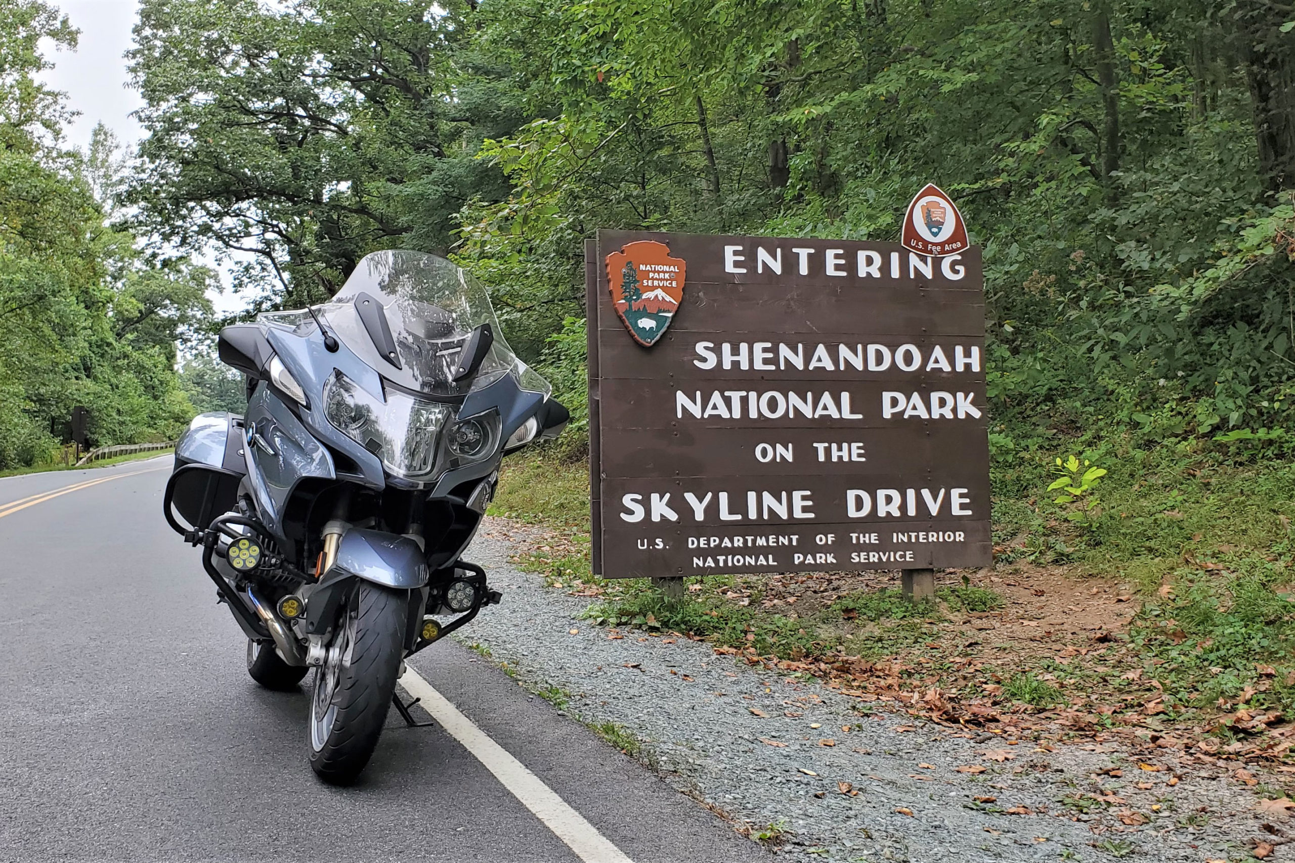
In the morning we hop on Skyline Drive to curve through Shenandoah National Park. On a dreary weekday after Labor Day, the few vehicles we encounter are noticeably disregarding the painfully slow 35-mph speed limit. After we join the Blue Ridge Parkway, the rain begins. Beyond Roanoke we shift to U.S. Route 221, and the rain continues to fall hard and steady, but as Steve reminds me, a great road in the rain is still a great road. In the town of Boone, North Carolina, we call it a day. Torrential rain and flash flood warnings will continue through the next 36 hours, so we opt for a rest day in this happening college town in the mountains.
The 35-mph speed limit on Skyline Drive provides all kinds of time to take in the scenery. Muriel would have liked that more than we do!
A day later, morning arrives with brilliant sun and temperatures in the low 40s. With heated gear plugged in, we make an early start. Branches and limbs litter the roads in a testament to the fierce storms that had rolled through. Steve shares warnings of road hazards ahead, a great benefit of bike-to-bike intercom. Especially in this region of Appalachia, the mountains form a creased and crumpled landscape, and the roads built into it twist and turn like a roller-coaster ride that you control. Rock outcroppings are common, and some are fascinating, such as one on U.S. 221, west of Blowing Rock, that looks like a face emerging from the mountain. Beyond North Cove we turn right on State Route 226 and left on State Route 226A to partake in another asphalt masterpiece.
Then, somewhere beyond Little Switzerland, an appropriate spot in the North Carolina mountains reveals itself and Muriel’s final request is fulfilled.
Dense gray clouds signal impending rain on Skyline Drive in Shenandoah National Park, Virginia.
Professionally, Muriel had been a city clerk, certifying elections, officiating weddings, and serving as president of the municipal clerks’ international association. She traveled extensively for work and in retirement. A simple church-going lady, she loved conversation, voiced strongly held opinions, and agreed to disagree (agreeably). One thing Muriel and I disagreed about was motorcycles, though curiously they brought us closer together. She knew how much motorcycles matter to me and that she lived in a special place to enjoy them, so of course I should come visit with friends.
On this trip, I gained the satisfaction of ensuring that Muriel’s wish to find rest in the mountains of North Carolina was met, and in the process Steve and I enjoyed some amazing roads. But there’s no escaping the irony that Muriel’s final ride was also her first ride on a motorcycle.
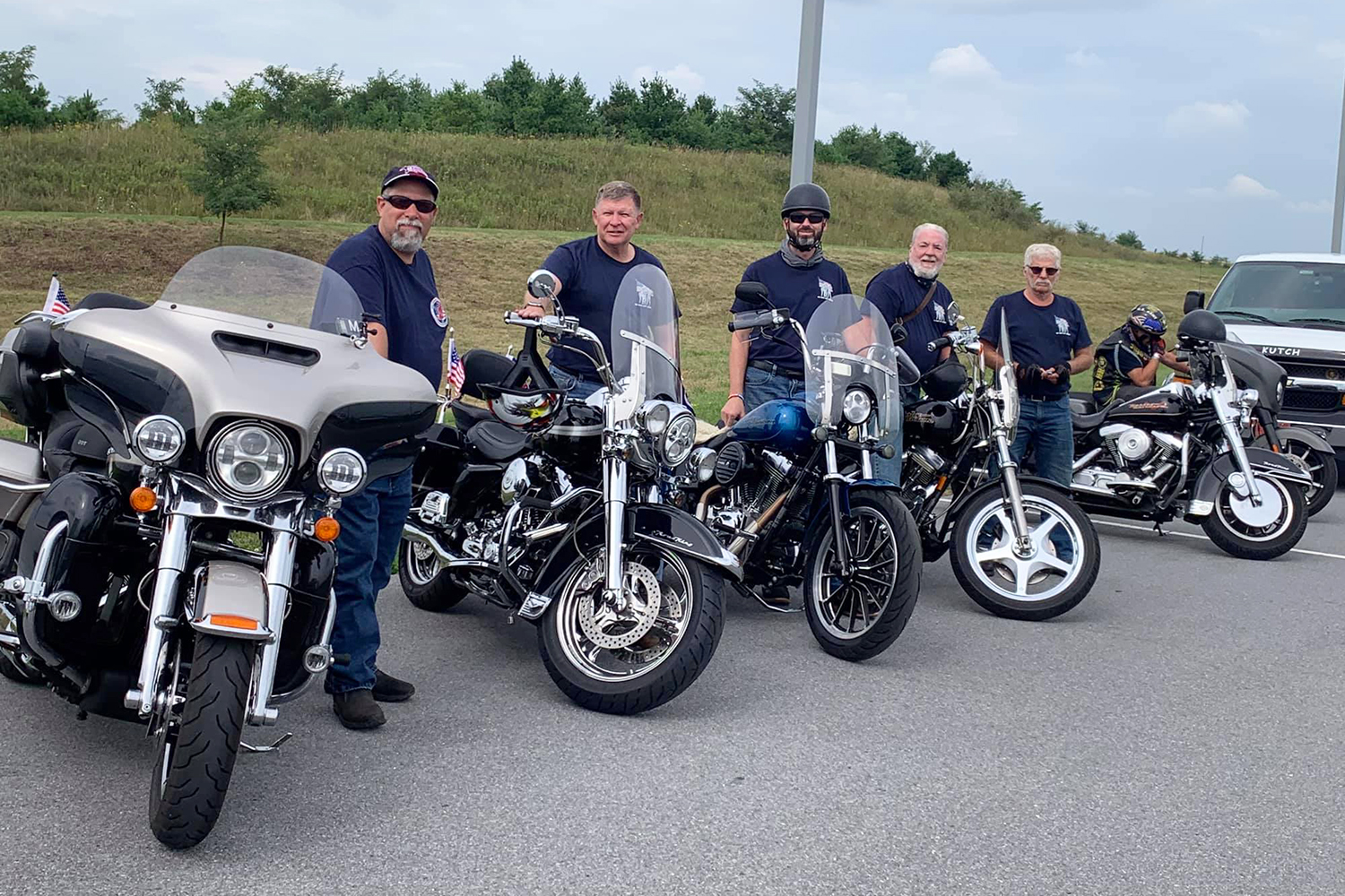
Riding For Warriors 7th annual tour riders. From left: Michael Nehlsen, Jim Kessler, James McQueen, Jim McQueen, Sr., Tom Stein, and Joey Mac Dizon.
The seventh annual Riding For Warriors event recently completed its six-day motorcycle ride to commemorate the 20th anniversary of 9/11, raising over $100,000 for Hope For The Warriors and its Warrior’s Wish program. Air Force veteran Michael Nehlsen led six of his fellow riders from his home state of New Jersey on a 900-mile journey ending in New York, visiting 9/11 memorials and related locations to remember and honor the victims of the attacks.
Hope For The Warriors is a 15-year-old nonprofit serving the warrior community — active-duty, veterans, military families, caregivers, and families of the fallen. Through one of its first established programs, Warrior’s Wish, Hope For The Warriors fulfills a desire for a better quality of life and works to provide rewarding experiences for those who have sacrificed their physical and psychological health in the line of duty.
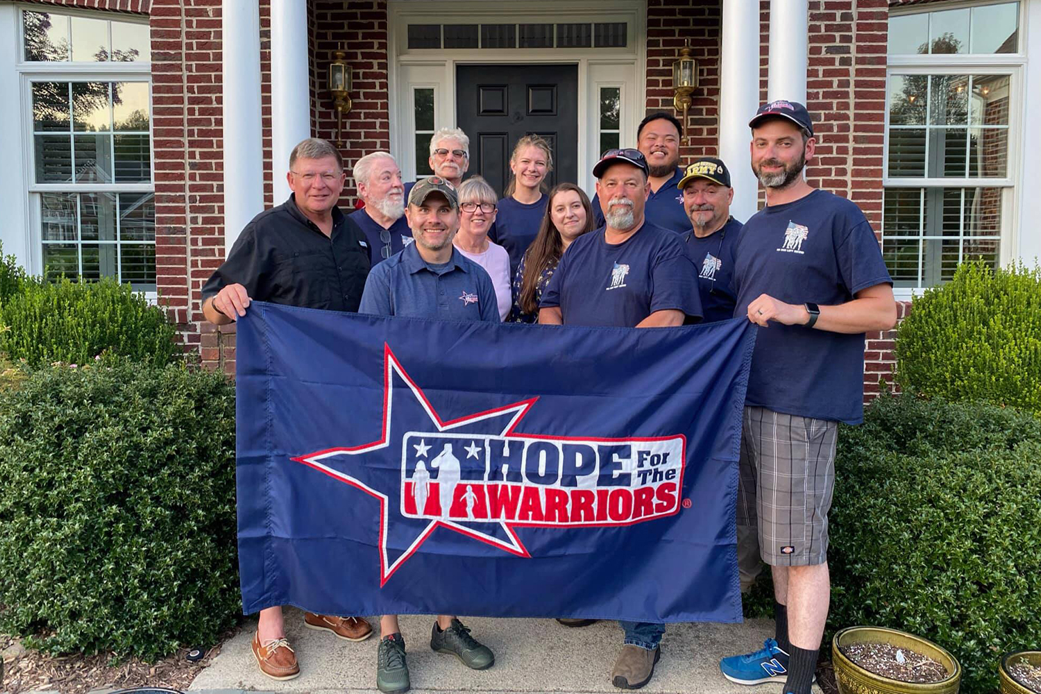
Front row behind flag: Jim Kessler, Matt Smith, Michael Nehlsen, James McQueen. Second row: Jim McQueen, Sr., Debbie Kessler, Rebecca Nehlsen, Frank Prigmore. Back row: Tom Stein, Anna Hillmann, Joey Mac Dizon
“Being the 20th Anniversary of 9/11 and being able to support our veteran community with Hope For The Warriors through the Warriors Wish program has been an honor and a privilege over the past seven years,” said Nehlsen. “The team of riders and support staff that accompanied me this year made the importance and impact of the journey from the NYC Ground Zero Memorial to the Flight 93 Memorial and finally to the Pentagon memorial a lifetime memory of brotherhood and sisterhood. We also met a lot of wonderful people along the way that have made a lifetime impact on me and I am sure all the others on the ride. 2021 solidified the very reason I started this journey seven years ago and will continue in the future. God Bless America and all our brothers and sisters who have served our great nation’s military past and present.”
This was the seventh year Nehlsen has led the tour and given his time to the charity, traveling over 30,000 miles on his motorcycle and raising over $253,000 for Warrior’s Wish, providing wounded veterans with woodworking and farm equipment, family trips, a horse trailer, a bass boat, bicycles and more.
“Every day we are reminded why Hope For The Warriors was born from the tragedies that took place on 9/11.” said Robin Kelleher, co-founder and president of Hope For The Warriors “The need to care for military families has not waned in the 20 years since the 9/11 attacks and it is with deep appreciation of Michael, Hillmann Consulting and the many supporters for sharing HOPE’s mission along the ride and raising critical funds to support our clients that need assistance”
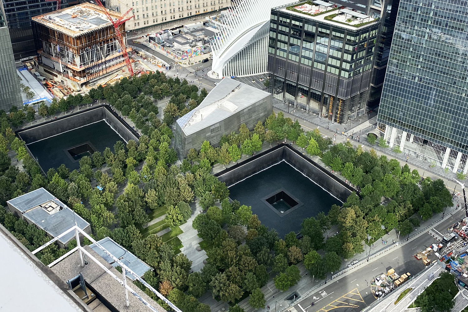
The 9/11 Memorial and Museum in New York City.
About Hope For The Warriors: Founded in 2006, Hope For The Warriors is a national nonprofit dedicated to restoring a sense of self, family, and hope for post-9/11 veterans, service members, and military families. Since its inception, Hope For The Warriors has served over 36,000 through a variety of support programs focused on clinical health and wellness, sports and recreation, and transition. One of the nonprofit’s first programs, Military Spouse and Caregiver Scholarships, has awarded over 170 scholarships to caregivers and families of the fallen.
For more information and to make a donation to Hope For The Warriors or its Warriors Wish program, visit: hopeforthewarriors.org
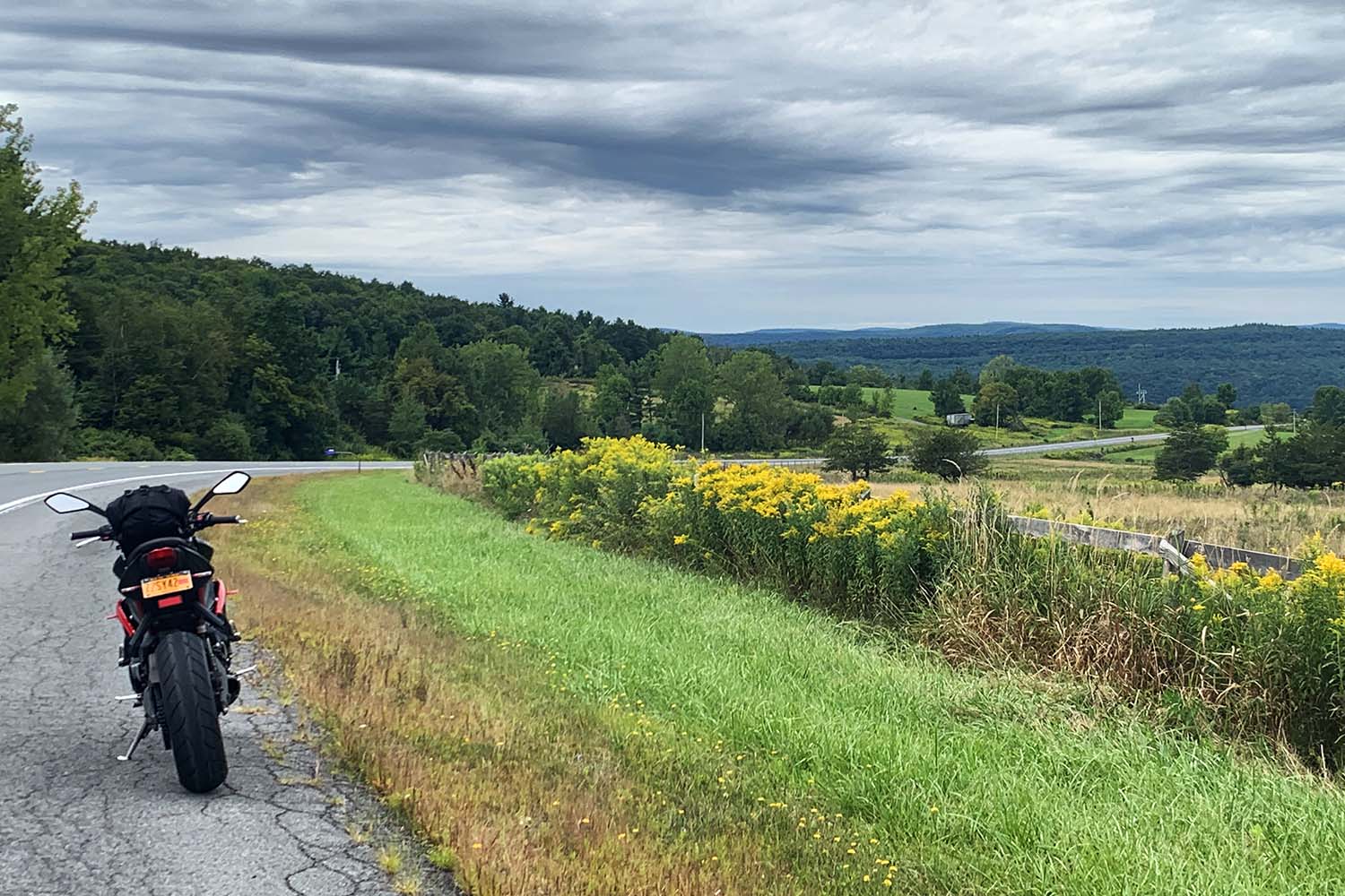
Upstate New York is rife with bucolic scenery. (Photos by the author)
The two Northeastern stops of the 2021 Progressive IMS Outdoors tour are on consecutive weekends in September. The New York City event will be at the Brooklyn Army Terminal, September 3-5 (Labor Day is the 6th), and the Pennsylvania event will be at the Carlisle Fairgrounds, September 10-12.
This 281-mile route begins in Saratoga Springs, in the heart of upstate New York’s farm and horse country. The town is home to the Saratoga Race Course, one of the oldest horse tracks in the country, dating back to 1863. The annual meet runs from mid-July to Labor Day, but there is harness racing year-round. Saratoga is famous for its mineral springs and bath houses, and there are plenty of excellent restaurants and vibrant nightlife to enjoy.
Saratoga Springs and the surrounding area make for a great escape from the city, or a worthy destination in their own right. You’ll find arts and culture, gambling, gourmet dining, outdoor adventures, and more.
The route leaves Saratoga Springs to the south, on U.S. Route 9, and passes through Malta. It turns east onto State Route 67 and crosses the Hudson River at Mechanicville. Continuing east, Route 67 passes through Schaghticoke and follows the Hoosic River. At Eagle Bridge, the route turns south, and it picks up State Route 22 at the town of Hoosic Falls. At Lebanon Springs, it turns west on U.S. Route 20, then southwest on State Route 66. After crossing Interstate 90 and passing through Chatham, it continues on the Taconic State Parkway.
The 104-mile parkway took 40 years to build, from the mid-1920s until its completion in 1963. Parts of the road were designed by Franklin D. Roosevelt during his tenure as head of the Taconic State Park Commission, and we can thank him for insisting those sections follow the natural landscape instead of powering through in a straight line. Built in a simpler time, the Taconic has narrow lanes, minimal shoulders, and plenty of gentle curves, but do be on the lookout for accidents and state troopers.
The route ends at the George Washington Bridge in Manhattan. From there, many options are available to get to the Brooklyn Army Terminal, which is off the Belt Parkway (Interstate 287) on the edge of Upper Bay. Enjoy the show!
For more information about Progressive IMS Outdoors and to buy tickets, visit motorcycleshows.com.Rider is the media partner for the Adventure Out! area at IMS Outdoors.
Saratoga is horse country and thoroughbred farms abound. The Triumph Street Triple packs a few horses of its own.
Several times a year I ride north from my home in New York City to Saratoga Springs to visit family. Like any motorcyclist worth her salt, I’ve sussed out some truly glorious roads and turn what is normally a 350-mile roundtrip into a meandering 500-plus miles. Saratoga Springs and the surrounding area make for a great escape from the city, or a worthy destination in their own right. Options for entertainment run the gamut from arts and culture to gambling, outdoor adventures and gourmet dining — there’s something for every rider in your group.
The easiest way to get out of the city while still enjoying the ride is to take the Taconic State Parkway north. Long stretches of the roadway are in rough shape, and some of the worst patches are in big sweeping curves. Should you choose to roll on the throttle through those curves, I recommend good suspension and extra Vitamin I (ibuprofren). Or you can test your handling skills by navigating a slalom course between the potholes, like I do on my Triumph.
Allow me a moment to wax rhapsodic about my Street Triple. I used to ride a Bonneville, and while the beautiful Bonnie will always have a place in my heart, as a smaller, lighter rider, a sportier bike suits me better. The Street Triple is the very definition of “flickable,” and while my 2015 doesn’t have a ton of low-end torque, the smooth acceleration through the upper rev range makes getting there a pleasure. There is little that can compare to the distinctive pop-pop-pop of that throaty triple, mine made even rowdier with a Two Brothers slip-on exhaust.
Upstate New York is rife with bucolic scenery.
Now, where was I? Right, potholes on the Taconic.
The 104-mile parkway took 40 years to build, from the mid 1920s until its completion in 1963. Parts of the road were designed by Franklin D. Roosevelt during his tenure as head of the Taconic State Park Commission, and we can thank him for insisting those sections follow the natural landscape instead of powering through in a straight line. Built in a simpler time, the Taconic has narrow lanes and minimal shoulders. Posted at 50 and then 55 mph, the nimble Street Triple is perfectly suited to slip through bottlenecks created by drivers white-knuckling along at 40 mph. Though a state parkway, it isn’t boring and has plenty of gentle curves, but do be on the lookout for accidents and state troopers.
A view over Saratoga Lake so beautiful even a hummingbird needed a moment to take it in.
The Taconic ends at the junction with Interstate 90, but a better choice is to take back roads up to Saratoga Springs through farm and horse country. The town is home to the Saratoga Race Course, one of the oldest horse tracks in the country, dating to 1863. The annual meet runs from mid-July to Labor Day, but there is harness racing year-round. Saratoga is famous for its mineral springs and bath houses, and there are plenty of excellent restaurants and vibrant nightlife to enjoy. Its extensive, elegant historical district showcases many pristine Victorian mansions.
View from a hill south of Amsterdam. In the distance, I-90 powers west through the Mohawk Valley.
To head south back to New York City, I start by cutting 30-odd miles west to Amsterdam on State Route 67. There are rolling fields of corn and that upstate staple, Stewart’s Shops, where you can stop for a quick coffee and a warm-up. Even midsummer mornings can be chilly this far north. Amsterdam’s story is like that of many upstate towns, especially those along the Erie Canal. Industry boomed and then died, and now these places are trying to reinvent themselves for the modern era. Some are faring better than others, but almost all of them retain a shadow of their former glory in architecture and design, which makes a trip through this area feel like a trip back in time.
Route 67 runs into Route 30 near the intersection of all the major arteries in the area, including the muscular Mohawk River. A primary tributary of the Hudson, the Mohawk looks serene in the summer but is prone to dangerous floods, particularly in spring when the snow melt comes roaring down. Take Route 30 over the river and over the Thruway, and then civilization quickly gives way to the lovely curves and hills of the Schoharie Valley.
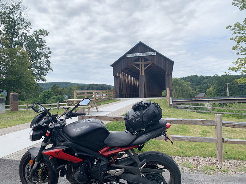
The original Blenheim Covered Bridge dates to 1829 and has been painstakingly restored. It claims the title as the longest single-span wooden bridge in the world, though it no longer connects to anything.
You don’t have to enjoy the smell of cow barns but it won’t hurt if you do, as Route 30 runs through mile after mile of farmland. Every 20 miles or so you’ll slow down from 55 to 45 to 35, one small town after another like links on a chain. If you’re fussy about filling up with 93 octane you may have to wait a minute to find a station, but they do exist.
These little towns are a living history of the ups and downs of upstate New York. Some look a lot worse for the wear while others have managed to thrive, hanging baskets of petunias cheerily welcoming just as you see the 35 mph sign. But all the parts of Route 30 are rife with historical markers and sites, including several covered bridges. Drop a kickstand and look around.
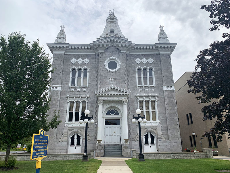
The Schoharie County Courthouse, beautifully preserved since 1870.
The upper portion of Route 30 often mirrors the curves of Schoharie Creek, making for a meditative, hypnotic ride. The Schoharie turns east just outside of the ambitiously named Grand Gorge, south of which are the headwaters of the East Branch Delaware River. Here the road flirts along with the creek as it gradually builds in volume, both you and the waters being drawn south.
I recommend stopping for a break in Margaretville. Ice cream at the Bun n’ Cone is optional, but however you refresh, you’ll want to feel bright-eyed and bushy-tailed before you hit the next section of the road. Follow the signs to stay south on Route 30 and enjoy 30 miles of pure happiness as the road undulates along the Pepacton Reservoir. My favorites are the big sweeping horseshoe curves, the kind motorcyclists dream of — the ones that seem to go on forever and challenge even the most experienced riders to hold their line, creating that perfect harmony of rider and road and machine.
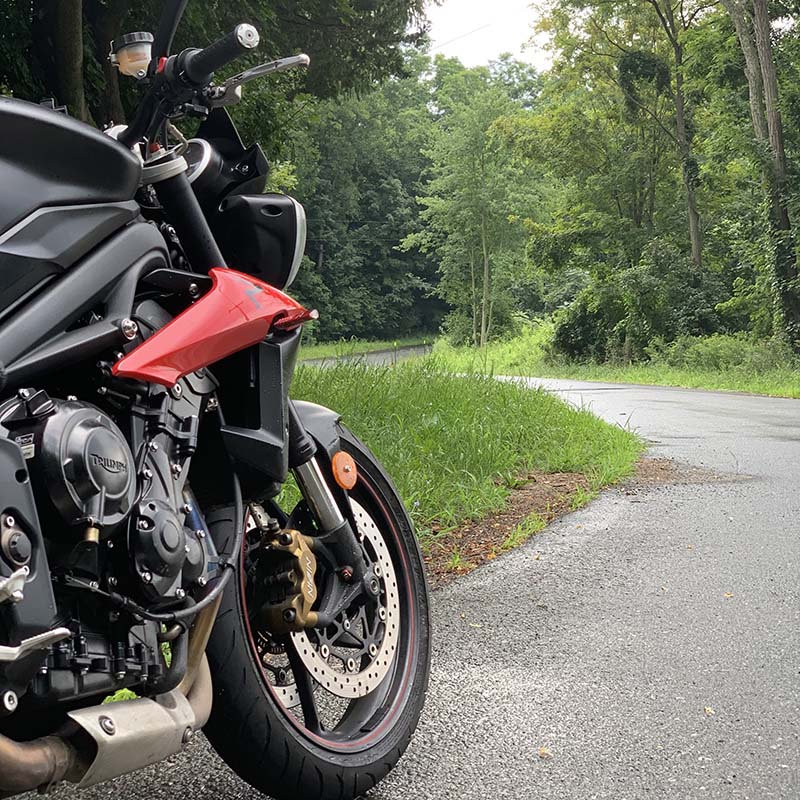
A quiet back road in the Catskills.
The road along the reservoir is in fair to very good condition, some stretches recently repaved. I’ve seen all manner of bikes on this road and can pretty much guarantee that whatever you ride, it’ll feel like it was made for the Pepacton. In addition to those glorious sweepers, there are lovely views of the reservoir and, as the western shore marks the Blue Line boundary of the Catskill Park, the surrounding forests are thickly green in the summer and a riot of color in the fall.
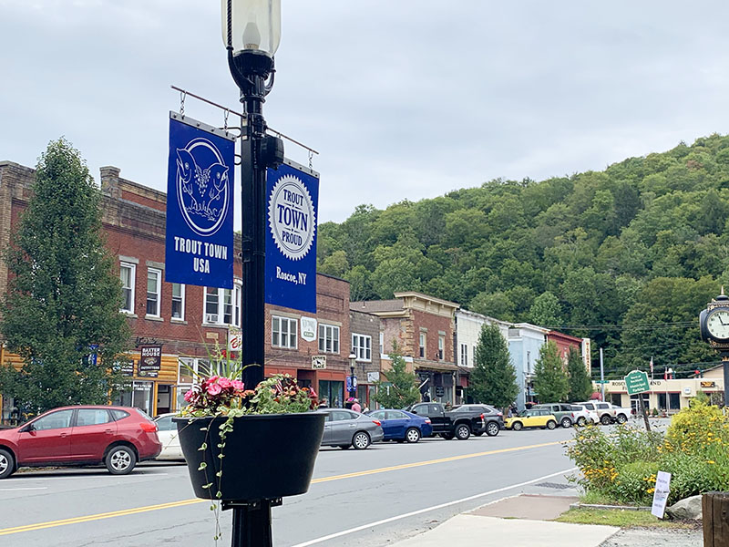
You may well be tempted to make the run down to Downsville and then back up to the top once or twice, and there’s no shame in pursuing that desire. It’s a gorgeous road and deserves to be enjoyed. When you’re about out of gas, or it’s dark, or you were supposed to be home three hours ago, I recommend heading east on Route 206, another pretty little road that pops you over a hill and down into the town of Roscoe, which has staked its claim as Trout Town, USA. There are several breweries and distilleries in the area, which makes a compelling case for booking a room and making Roscoe your home for the night.
Roscoe, New York, aka Trout Town, USA, has a homey, small-town feel to it. Decades ago the New York Ontario & Western Railway used special “trout cars” to carry millions of hatchlings to stock local rivers and streams.
Roscoe has several small-town attractions, including a railway museum and a bridge handy for watching fly fishers ply their trade. If I’ve hit Roscoe by 1 p.m. or so I usually take the long way home — Route 30 down to Deposit and Route 97 along the Delaware River to Port Jervis. If you’ve spent your day riding Pepacton over and over again, you can pick up Route 17 and deadhead it about 80 miles back to the city.
The next time you ride out to Pepacton, add Route 10 along the Cannonsville Reservoir to your itinerary. There’s little in the world like the feeling of taking one of those big sweepers, the road unspooling ahead and the bike humming beneath, your hand on the throttle and your eyes up toward the exit, chasing that white line rolling away before you, the exhausting thrill of knowing you have so many more excellent miles to go.
The rugged nautical majesty of Maine’s historic Nubble Lighthouse on Cape Neddick frames the Chieftain Elite. Story and photos by Phil Buonpastore.
My cousin Jim Pace, an avid motorcyclist and native of New Hampshire, and I had long discussed touring New England from his home in Barrington, and our bucket-list ride was finally planned for last summer. Indian Motorcycles arranged for me to borrow a 2020 Chieftain Elite from Motorcycles of Manchester, so with all of the pieces in place, I flew to New Hampshire in July. The ride to Barrington gave me an opportunity to get accustomed to the bike.
A stop at a scenic overlook on the ribbon-like Mt. Washington Auto Road.
Not long after cousin Jim and I embarked on a loop ride around Lake Winnipesaukee. Leaving Barrington on New Hampshire Route 11, gradual sweepers punctuated by a few tight turns took us along the western side of Bow Lake. Here, towns and traffic gradually disappear and the road begins to elevate to the Lake Winnipesaukee Scenic Islands Viewing Area, cresting a high embankment revealing elevated views of Diamond, Rattlesnake and Sleeper’s Island in the lake below, with rolling foothill mountains in the distance.
At Glendale, NHR3 and NHR25 wind for 26 miles along the western shore of Lake Winnipesaukee. The lakefront town of Weirs Beach, location of the annual Laconia Motorcycle Week rally that brings thousands of motorcyclists to the area each June, is also a popular spot for tourists. After stopping for some locally made ice cream and people watching, we continued northeast on low stress two-lane country highway through mild curves, rolling hills and forest until reaching NHR16, also known as the White Mountain Highway, then turned south through the towns of Ossipee, Wakefield and Milton. A detour on First Crown Point Road for a quick jaunt through Blue Job Mountain State Forest and it was back to Barrington, completing a 3.5-hour, 150-mile afternoon ride.
An abandoned Indian Motocycles truck trailer offers a surprise photo-op in Milton, New Hampshire.
The next day’s plan was to ride 60 miles north on a loop that would encompass both the Franconia and Crawford Notches, the well-known valley passes through the White Mountains. Heading north on NH16 through scenic countryside, we passed through the town of Milton, and happened upon the most surprising photo op of the week — an abandoned truck trailer painted bright yellow, with the classic Indian Motocycles logo painted in red and a rendering of a 1940’s vintage Chief motorcycle. It was an absolute must stop for photos of the new Chieftain.
A stop for a roadside break at the Ossippe River near the town of Effingham Falls.
At Union, NHR153 is the preferred route, offering taller hills and tighter curves than the highway. Once to Conway, we headed west on the must-ride Kancamagus Highway. The first 20 miles of the highway begins leisurely and sedate, paralleling the Swift River to the Sugar Hill Scenic Vista, featuring hiking trails and the opportunity to take a cool dip on a hot summer’s day. But the fun for a rider is in the second 20 miles, where the valley between Mount Hancock and Mount Osceola offer major changes in elevation and a sequence of increasingly challenging twisties, topped by a 200-degree classic hairpin turn around the Hancock Overlook.
The Ride up the Mt. Washington Auto Road was blanketed by thick fog for most of the ride to the summit. Cousin Jim cautiously surveys the road ahead.
At the town of Woodstock, the Kancamagus ends. Turning north on U.S. Route 3, the Daniel Webster Highway is a relaxing ride that leads through Franconia Notch State Park, a focal point for hiking trails that go up to five mountains: Lafayette, Liberty, Flume, and the Cannon and Kinsman Mountains that surround the park. North of Franconia Notch, U.S. Route 3 goes east toward U.S. Route 302 and Mount Washington. Here the skies clouded, and intermittent light rain began to fall, putting a damper on the enjoyment of the day. A quick stop to don rain gear and take photos of the magnificent Mt. Washington Hotel on a cloudy day, and we continued through the Crawford Notch to Conway, where sunshine and blue sky returned. After a stop for bygone-era photos at the Conway Railroad Museum, we returned to Barrington through broken clouds, completing 205 miles and 4.75 hours of ride time. The loop was spectacular, but we would need another opportunity to fully enjoy the Crawford Notch and Washington Hotel in better weather.
At the summit, the Sherman Adams Building houses the Mt. Washington Observatory and Museum, and chains anchor the Tip-Top House to the mountain. Wind velocities here have been recorded as high as 231 mph.
By midweek, the days had become sunny, clear and blue, perfect for a ride to the top of Mt. Washington State Park. Taking NH16 north for 75 miles brought us to the park entrance at about 1 p.m. After paying the $20 entrance fee and getting our “This Bike Climbed Mt. Washington” bumper stickers, we started up the very twisty, ribbon-thin 7.6-mile Auto Road to the top of Mt. Washington. The road is hardly wide enough for two cars, and the ride to the summit was made all the more interesting by a heavy fog that settled on the mountain about halfway up, sometimes limiting vision to less than 50 feet, with a road section under repair reduced to dirt and gravel. Keep calm, and keep moving. Still, I couldn’t pass up opportunities for ghost-like photos, with headlights appearing and disappearing as they passed in the fog.
At the road’s end is Mount Washington State Park, a 60-acre site topping the 6,288-foot summit of the Northeast’s highest peak, surrounded by the 750,000-acre White Mountain National Forest. Mt. Washington is famous for having the highest recorded wind velocity ever measured in the U.S., an astounding 231 mph, and the summit building built in the 1930s is chained to the ground in order to withstand the sometimes very high winds. On clear days, summit views extend as far as 130 miles to Vermont, New York, Massachusetts, Maine, Quebec and out to the Atlantic Ocean. Breaks in the fog allowed for some amazing views into the Tuckerman Ravine. The well-known Appalachian Trail also crosses the Auto Road about halfway up to the summit.
The Sherman Adams Building houses the Mount Washington Observatory and Museum, and the Tip-Top House, a hotel built in 1853 and renovated in 1986 for historic tours. While Covid-19 restrictions had closed these facilities to the public, the Mt. Washington Cog Railway was operating. Built in 1866 by Sylvester Marsh, these unique and beautiful period trains use a giant cog-style gear and rack system to pull railcars up the mountain at angles from 25 to as great as 38 degrees, transporting visitors from the Marshfield Base Station near the Mt. Washington Hotel to the top of the mountain.
One of the few operating in the U.S., the colorful Mt. Washington Cog Railway uses a gear and rack system to operate on inclines from 25 to 38 degrees.
As rainy weather had previously kept us from experiencing the Crawford Notch and Mt. Washington Hotel in all their brilliant glory, we took a detour on U.S. Route 302 to make another pass through the notch and a get second look at the hotel. This time, we were not disappointed. Closing in on the golden hour, the late afternoon sunlight bathed the steep mountainsides in deep amber as we rode through the notch.
The Crawford Notch runs through the White Mountains some 4,000 feet overhead.
The Mt. Washington Hotel is a massive and beautiful structure of the grandest design built in 1902. Its history boasts the signing of the agreement for the creation of the World Bank and International Monetary Fund in 1944, and the filming of scenes from the movie “The Shining,” as well as supposedly being haunted by a ghost named Carolyn, the wife of the hotel’s builder and first owner, Joseph Stickney. I am not sure, however, if any of this information recommends a night’s stay there! After a walk through the hotel to take in the building’s beautiful interior and the large semi-circular patio that overlooks the golf course and mountains behind, and we were riding once again.
The spectacular Mt. Washington Hotel, built in 1902, has hosted presidents and world dignitaries.
Passing through the town of Freedom, we saw an old rustic barn with a sign reading “Freedom Farm” above its double doors, an obvious final photo-op of the day. With the afternoon spent on Mt. Washington, we arrived home after dark, completing a 225-mile loop.
The “Freedom Farm” in the town of Freedom affirms both the New Hampshire motto and the rider’s resolve: “Live Free or Die.” Center: U.S. 1A, or Long Beach Avenue, runs through the seaside town of York, and within yards of the Atlantic Ocean.
The next day it was time for something completely different — a seaside ride on the coast of Maine. Taking NHR9 and Dover Point Road to Portsmouth then crossing the Maine border, we rode out toward the Atlantic coast on Maine Route 103, a lovely Maine low-country ride along small rivers and waterways and through coastal communities, serene and peaceful. MR103 changes road names from Shapleigh to Whipple to Tenny Hill to Brave Boat Harbor Road before crossing the York River, leading to a right turn onto U.S. 1A, also known as Long Beach Ave. Within a few miles, the road turns parallel to the coast and within feet of the Atlantic Ocean, often separated only by public beach and sidewalk. The day granted perfect riding weather — clear blue skies, low 80-degree temperatures and scattered cumulus. A detour on Nubble Road through spectacular oceanfront residences led to the Nubble Lighthouse, perched on its own island and picture-perfect. North of the lighthouse, we continued through the York Cliffs, Bald Head and Ogunquit areas, with the road becoming less populated as it reached the coastal Wells National Estuarine Research Reserve, then to the beautiful town of Kennebunkport, vacation spot of presidents. Maine Route 9A to New Hampshire Route 9 served for a fine open-country ride on the one-hour return to Barrington.
Built in 1879, The Nubble Lighthouse, also known as the Cape Neddick Light, is still in use today.
My arrangements with Indian included returning the motorcycle in Florida, and later that week I began the ride south. New Hampshire and Maine had been new territory for me, and there is a lot of riding there yet to be done. Looks like I’ll need a bigger bucket.
Built in 1879, The Nubble Lighthouse, also known as the Cape Neddick Light, is still in use today.
New England Loops: A Bucket-List Ride in New England Photo Gallery:
Bringing you the Best Motorcycle News from Around the Web!
We use cookies to ensure that we give you the best experience on our website. If you continue to use this site we will assume that you are happy with it.Ok